Scientists say warming makes storms, like Harvey, wetter

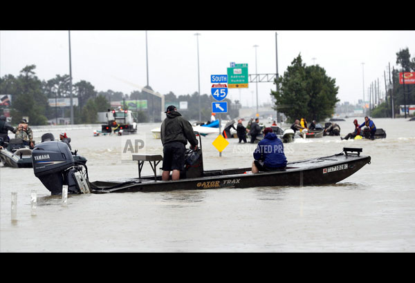
Volunteer rescue boats make their way into a flooded subdivision to rescue stranded residents as floodwaters from Tropical Storm Harvey rise Monday, Aug. 28, 2017, in Spring, Texas. (AP Photo/David J. Phillip)
WASHINGTON — By the time the rain stops, Harvey will have dumped about 1 million gallons of water for every man, woman and child in southeastern Texas — a soggy, record-breaking glimpse of the wet and wild future global warming could bring, scientists say.
While scientists are quick to say climate change didn't cause Harvey and that they haven't determined yet whether the storm was made worse by global warming, they do note that warmer air and water mean wetter and possibly more intense hurricanes in the future.
"This is the kind of thing we are going to get more of," said Princeton University climate scientist Michael Oppenheimer. "This storm should serve as warning."
There's a scientifically accepted method for determining if some wild weather event has the fingerprints of man-made climate change, and it involves intricate calculations. Those could take weeks or months to complete, and then even longer to be checked by other scientists.
In general, though, climate scientists agree that future storms will dump much more rain than the same size storms did in the past.
That's because warmer air holds more water. With every degree Fahrenheit, the atmosphere can hold and then dump an additional 4 percent of water (7 percent for every degree Celsius), several scientists say.
Global warming also means warmer seas, and warm water is what fuels hurricanes.
When Harvey moved toward Texas, water in the Gulf of Mexico was nearly 2 degrees (1 degree Celsius) warmer than normal, said Weather Underground meteorology director Jeff Masters. Hurricanes need at least 79 degrees F (26 C) as fuel, and water at least that warm ran more than 300 feet (100 meters) deep in the Gulf, according to University of Miami hurricane researcher Brian McNoldy.
Several studies show that the top 1 percent of the strongest downpours are already happening much more frequently. Also, calculations done Monday by MIT meteorology professor Kerry Emanuel show that the drenching received by Rockport, Texas, used to be maybe a once-in-1,800-years event for that city, but with warmer air holding more water and changes in storm steering currents since 2010, it is now a once-every-300-years event.
There's a lot of debate among climate scientists over what role, if any, global warming may have played in causing Harvey to stall over Texas, which was a huge factor in the catastrophic flooding. If the hurricane had moved on like a normal storm, it wouldn't have dumped as much rain in any one spot.
Harvey stalled because it is sandwiched between two high-pressure fronts that push it in opposite directions, and those fronts are stuck.
Oppenheimer and some others theorize that there's a connection between melting sea ice in the Arctic and changes in the jet stream and the weather patterns that make these "blocking fronts" more common. Others, like Masters, contend it's too early to say.
University of Washington atmospheric scientist Cliff Mass said climate change is simply not powerful enough to create off-the-chart events like Harvey's rainfall.
"You really can't pin global warming on something this extreme. It has to be natural variability," Mass said. "It may juice it up slightly but not create this phenomenal anomaly."
"We're breaking one record after another with this thing," Mass said.
Sometime yesterday or early Wednesday, parts of the Houston region will have broken the nearly 40-year-old US record for the heaviest rainfall from a tropical system — 48 inches (120 centimeters), set by Tropical Storm Amelia in 1978 in Texas, several meteorologists say.
Already 15 trillion gallons (57 trillion liters) of rain have fallen on a large area, and an additional 5 trillion or 6 trillion gallons are forecast by the end of Wednesday, meteorologist Ryan Maue of WeatherBell Analytics calculates. That's enough water to fill all the NFL and Division 1 college football stadiums more than 100 times over.
- Latest
- Trending


