'Marce' gains strength, headed for landfall in Cagayan
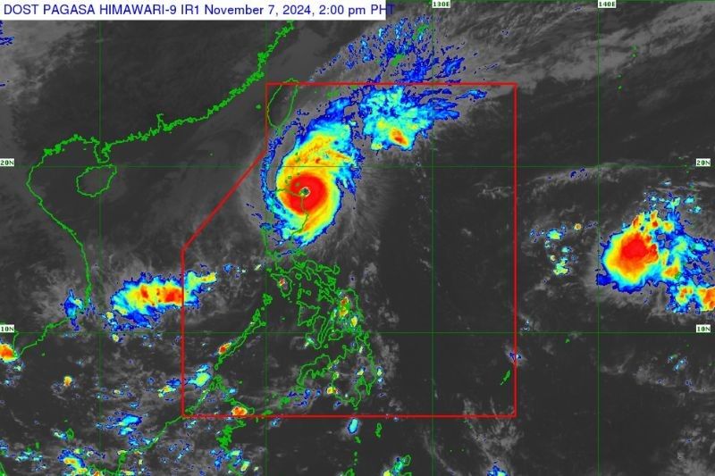
MANILA, Philippines — Signal No. 4 remains in effect in several areas of northern Luzon as Typhoon Marce (international name: Yinxing) further intensifies while approaching northeastern Cagayan on Thursday afternoon, November 7.
As of 2 p.m., state weather bureau PAGASA reported that Typhoon Marce's eye is located over the coastal waters of Santa Ana, Cagayan, with maximum sustained winds of 175 kilometers per hour (kph) and gusts reaching up to 240 kph.
Marce is moving west-northwestward at 10 kph and may briefly intensify to a super typhoon, according to PAGASA.
Wind signals
PAGASA placed the following areas under tropical cyclone wind signals:
Signal No. 4, typhoon-force winds (118 kph to 184 kph)
- northern portion of Cagayan (Gonzaga, Santa Ana, Santa Teresita, Lal-Lo, Buguey, Aparri, Camalaniugan, Gattaran, Ballesteros, Allacapan, Abulug, Pamplona, Sanchez-Mira, Claveria, Santa Praxedes, Lasam)
- Babuyan Islands
- northern portion of Apayao (Santa Marcela, Luna, Flora, Calanasan, Pudtol)
- northern portion of Ilocos Norte (Pagudpud, Bangui, Vintar, Dumalneg, Adams, Bacarra, Pasuquin, Burgos)
Signal No. 3, storm-force winds (89 kph to 117 kph)
- Batanes
- rest of Cagayan
- rest of Apayao
- rest of Ilocos Norte
- northern portion of Abra (Tineg, Danglas, Lagayan, Lacub, San Juan, La Paz, Bangued)
- northern portion of Ilocos Sur (Sinait, Cabugao, San Juan, Magsingal, Santo Domingo)
Signal No. 2, gale-force winds (62 kph to 88 kph)
- northern and central portions of Isabela (San Pablo, Santa Maria, Divilacan, Tumauini, Maconacon, Cabagan, Santo Tomas, Quezon, Palanan, Ilagan City, Mallig, Delfin Albano, Quirino, San Mariano, Gamu, Roxas, Naguilian, Burgos, Reina Mercedes, Benito Soliven, Luna, Aurora, San Manuel, San Mateo, Alicia, Angadanan, City of Cauayan, Cabatuan)
- rest of Abra
- Kalinga
- Mountain Province
- northern portion of Ifugao (Alfonso Lista, Aguinaldo, Mayoyao, Banaue, Hungduan)
- northern portion of Benguet (Bakun, Mankayan)
- rest of Ilocos Sur, and the northern portion of La Union (Sudipen, Bangar, Balaoan, Luna, Santol)
Signal No. 1, strong winds (39 kph to 61 kph)
- rest of La Union
- Pangasinan
- rest of Ifugao
- rest of Benguet
- rest of Isabela
- Quirino
- Nueva Vizcaya
- northern and central portions of Aurora (Dilasag, Casiguran, Dinalungan, Dipaculao, Maria Aurora, Baler)
- northern portion of Nueva Ecija (Carranglan)
- northern portion of Zambales (Santa Cruz, Candelaria)
Typhoon Marce’s northeasterly wind flow is expected to bring "strong to gale-force gusts" over Zambales, Bataan and Polillo Islands on November 7.
By Friday, November 8, PAGASA forecasts intense winds for the coastal and upland areas of Batanes, Cagayan, Babuyan Islands, Isabela and Ilocos Region.
Storm surge. The state weather bureau also warns coastal communities of Batanes, Cagayan, Babuyan Islands, Isabela, Ilocos Norte, Ilocos Sur and La Union of storm surges reaching heights exceeding 3 meters in the next two days.
It is also anticipated that seas will be “very rough, high or very high” reaching as high as 12 meters in affected coastal communities.
These include Zambales, northern Aurora, Kalayaan Islands, Polillo Islands, Camarines Norte, Camarines Sur, Catanduanes, Northern Samar, Albay, Sorsogon, Eastern Samar, Dinagat Islands, Surigao del Sur and Occidental Mindoro.
Forecast track
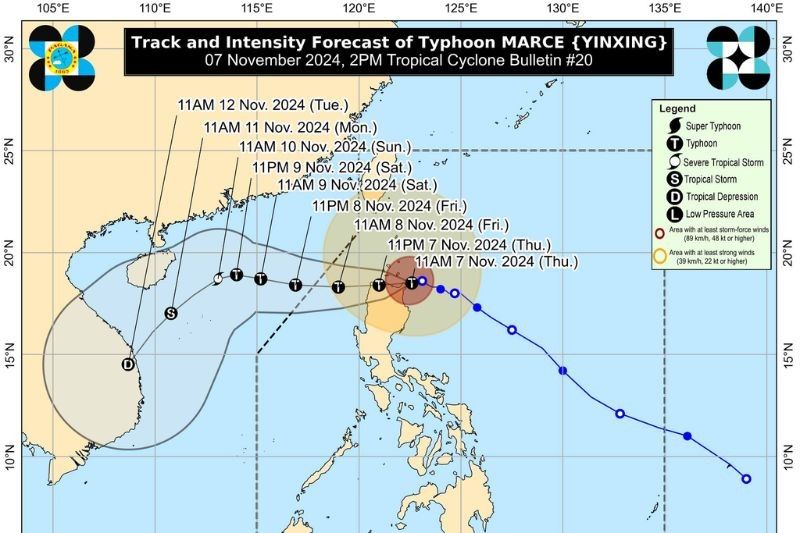
PAGASA said that Typhoon Marce is expected to make landfall in Santa Ana, Cagayan, between 2 p.m. and 4 p.m. on Thursday.
Marce is also forecasted to cross Aparri Bay and continue westward, making a second landfall in northwestern mainland Cagayan. By Friday morning, November 8, the typhoon is projected to be over the West Philippine Sea.
“Regardless of the position of the center of the eye in the next several hours, it must be emphasized that potentially life-threatening conditions due to typhoon-force winds, storm surge inundation, and torrential rainfall will be experienced in the Babuyan Islands and the northern portions of mainland Cagayan, Ilocos Norte, and Apayao,” PAGASA said.
The state weather bureau said that Marce is anticipated to exit the Philippine area of responsibility on Friday afternoon or evening, November 8.
- Latest
- Trending


