‘Kristine’ intensifies into severe tropical storm — PAGASA
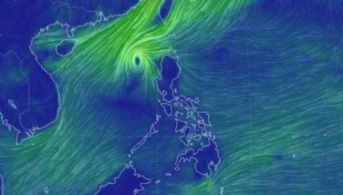
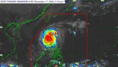
MANILA, Philippines — “Kristine” (international name: Trami) has intensified into a severe tropical storm on Wednesday, October 23, prompting state weather bureau PAGASA to raise Signal No. 3 over several parts of Luzon as it brings heavy rains and strong winds.
In PAGASA's 5 p.m. bulletin, the severe tropical storm was estimated 175 kilometers (km) east of Echague, Isabela with winds peaking at 95 km per hour (kph) moving north northwestward at 20 kph with gusts up to 115 kph.
PAGASA raised tropical cyclone wind signal no. 3 on the following areas:
- Isabela
- Kalinga
- Mountain Province
- Ifugao
- Central portion of Abra
- Benguet
- Quirino
- Nueva Vizcaya
- Northern and central portions of Aurora
- Northern portion of Nueva Ecija
- Pangasinan
- La Union
- Central and southern portions of Ilocos Sur
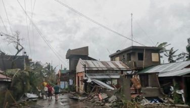
The state weather bureau warned of a moderate to significant threat to life and property in these areas due to wind speeds of 89 to 117 kph.
Meanwhile, tropical cyclone wind signal no. 2 was raised over the following areas:
- Ilocos Norte
- The rest of Ilocos Sur
- Apayao
- The rest of Abra
- Cagayan (including Babuyan Islands)
- The rest of Aurora
- The rest of Nueva Ecija
- Bulacan
- Tarlac
- Pampanga
- Zambales
- Bataan
- Metro Manila
- Cavite
- Laguna
- Rizal
- Quezon (including Polillo Islands)
- Camarines Norte
- Camarines Sur
- Catanduanes
PAGASA cautioned about a minor to moderate threat to life and property in these areas, with wind speeds ranging from 62 to 88 kph.
Signal no. 1 was also hoisted over the following areas:
Luzon
- Batanes
- Batangas
- Occidental Mindoro (including Lubang Islands)
- Oriental Mindoro
- Marinduque
- Romblon
- Calamian Islands
- Albay
- Sorsogon
- Masbate (including Ticao and Burias Islands)
Visayas
- Aklan
- Capiz
- Antique (including Caluya Islands)
- Iloilo
- Guimaras
- Northern portion of Negros Occidental
- Northern portion of Negros Oriental
- Northern and central portions of Cebu
- Bantayan Islands
- Camotes Islands
- Bohol
- Eastern Samar
- Northern Samar
- Samar
- Leyte
- Biliran
- Southern Leyte
Mindanao
- Dinagat Islands
- Surigao del Norte (including Siargao and Bucas Grande Group)
The state weather bureau warned of minimal to minor threats to life and property in these areas due to wind speeds of 39 to 61 kph.
Track forecast
Kristine is expected to move predominantly northwest for the next 12 hours before shifting westward for the remainder of the forecast period, according to PAGASA.
It is projected to make landfall over Isabela tonight or early tomorrow morning, 24 October.
It will then traverse the mountainous regions of northern Luzon and re-emerge over the waters west of the Ilocos Region tomorrow morning.
The severe tropical storm could leave the Philippine area of responsibility by Friday, October 25.
Additionally, Kristine is anticipated to continue strengthening until it reaches land. There may be a slight weakening during its passage over Northern Luzon, followed by a potential re-intensification as it moves over the West Philippine Sea.


- Latest
- Trending