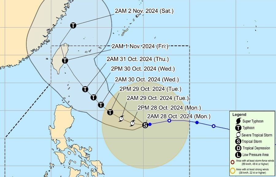
After 'Kristine': Storm 'Leon' advances toward Luzon
MANILA, Philippines — Tropical Storm Leon (international name: Kong-rey) has maintained its strength as it decelerates over the Philippine Sea on Monday morning, October 28, with tropical cyclone wind signals up over some areas that are still recovering from effects of Tropical Storm Kristine.
As of 4 a.m. AM, the center of Leon was estimated at 840 kilometers east of Central Luzon, with maximum sustained winds of 85 kilometers per hour (kph) near the center, gustiness of up to 105 kph.
The storm is currently moving westward at a slower pace of 10 kph.
While it hoisted Signal No. 1 over portions of Northern Luzon, state weather bureau PAGASA said Signal Nos. 2 or 3 would be the highest possible warnings to be raised as Leon barrels across the Philippine area of responsibility.
Signal No. 1 raised
Tropical Cyclone Wind Signal No. 1 has been called over the following areas:
- The eastern portion of mainland Cagayan (Santa Ana, Lal-Lo, Gattaran, Baggao, Santa Teresita, Gonzaga, Peñablanca)
- The eastern portion of Isabela (Maconacon, Divilacan, Ilagan City, San Pablo, Cabagan, Tumauini, Palanan, San Mariano, Dinapigue)
- The northeastern portion of Catanduanes (Pandan, Bagamanoc, Panganiban, Viga)
These areas may experience strong winds with speeds ranging from 39 to 61 kph within the next 36 hours, posing a minimal to minor threat to life and property.
Effects
The outer rainbands of Leon may affect Extreme Northern Luzon, depending on its proximity during its north northwestward movement over the Philippine Sea.
Additionally, the trough of Leon may also bring rainfall to areas in Visayas, Mindanao, and the western section of Southern Luzon.
Strong to gale-force winds are expected in coastal and upland areas of Batangas, most of MIMAROPA, most of Bicol Region, Visayas, most of Northern Mindanao, and most of Caraga Region today (October 28).
Similar conditions may affect Aurora, Metro Manila, CALABARZON, MIMAROPA, Bicol Region, Visayas, Dinagat Islands, Surigao del Norte, and Camiguin tomorrow (October 29), and Aurora, Metro Manila, CALABARZON, MIMAROPA, Bicol Region, Western Visayas, Negros Occidental, and Northern Samar on Wednesday (October 30).
Sea conditions. Rough to very rough seas are expected in the seaboards of Batanes, Babuyan Islands, Isabela, mainland Cagayan, northern Aurora, Camarines Norte, Polillo Islands, Camarines Sur, Catanduanes, Northern Samar, and Eastern Samar.
Sea travel is considered risky for all types of vessels in these areas, and mariners are advised to remain in port or seek shelter until conditions improve.
Forecast track
Leon is expected to move westward in the next 12 hours before turning west northwestward on October 29.

It may then turn northwestward by October 30 until October 31, potentially passing closely over the Batanes area.
The storm is forecast to gradually intensify and may reach severe tropical storm category by this afternoon, with the possibility of rapid intensification.
- Latest
- Trending


