‘Leon’ intensifies into a typhoon

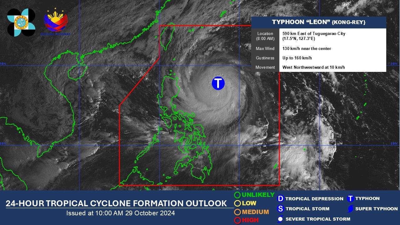
MANILA, Philippines (Updated 11:43 a.m.) — Cyclone Leon intensified from a severe tropical storm to a typhoon, according to the state weather bureau on Tuesday, October 29.
PAGASA had earlier forecast that Leon was likely to gain strength. There is also a chance that it may become a super typhoon as it approaches Batanes.
In a Facebook post, PAGASA now classified Leon as a typhoon as of 10:00 am.
Leon has maximum sustained winds of 130 kilometers per hour near the center and gustiness of up to 160 kph. It is moving west northwestward at 10 kph.
Following Leon’s intensification, PAGASA has raised Tropical Cyclone Wind Signal (TCWS) Nos. 1 and 2 in several areas in northern Luzon.
TCWS No. 2
- Batanes
- Babuyan Islands
- Eastern portion of mainland Cagayan (Gattaran, Baggao, Lal-Lo, Aparri, Camalaniugan, Buguey, Santa Teresita, Gonzaga, Santa Ana, Pe)
- Northeastern portion of Isabela (Divilacan, Palanan, Maconacon)
TCWS No. 1
- The rest of mainland Cagayan
- The rest of Isabela
- Quirino
- Nueva Vizcaya
- Apayao
- Kalinga
- Abra
- Mountain Province
- Ifugao
- Benguet
- Ilocos Norte
- Ilocos Sur
- La Union
- Aurora
- Northern portion of Quezon including Polillo Islands (General Nakar, Infanta, Real)
- Camarines Norte
- Eastern portion of Camarines Sur (Tinambac, Siruma, Goa, Lagonoy, San Jose, Garchitorena, Caramoan, Presentacion, Tigaon, Calabanga, Saglay)
- Catanduanes
- Eastern portion of Albay (Rapu-Rapu, Bacacay, City of Tabaco, Tiwi, Malilipot, Malinao, Santo Domingo, Manito)
- Northeastern portion of Sorsogon (Prieto Diaz, City of Sorsogon, Gubat)
PAGASA has also hoisted a gale warning over the Northern Luzon seaboard and the eastern seaboards of Central and Southern Luzon.
Leon is set to keep moving northwestward until it makes landfall along the eastern coast of Taiwan on October 31.
“Leon will be closest to Batanes between Thursday early morning and noon. Furthermore, considering the possibility of further westward shift in the track forecast (but within the limits of the forecast confidence cone), a landfall scenario on Batanes is not ruled out,” PAGASA said.
The state weather bureau said that there is an “increasing chance” that Leon may reach super typhoon category.
In its morning advisory, PAGASA said that Batanes, Cagayan and the Babuyan Islands should brace for torrential rains on Tuesday as cyclone Leon intensifies.
Meanwhile, Ilocos Norte, Apayao, Occidental Mindoro and Antique can also anticipate intense rains.
Moderate to heavy rains are forecast over Ilocos Sur, Isabela, Abra, Kalinga, Calamian Islands, Romblon, Negros Occidental and Aklan.
- Latest
- Trending


