More Cebu LGUs placed under Signal No. 1 Sunday

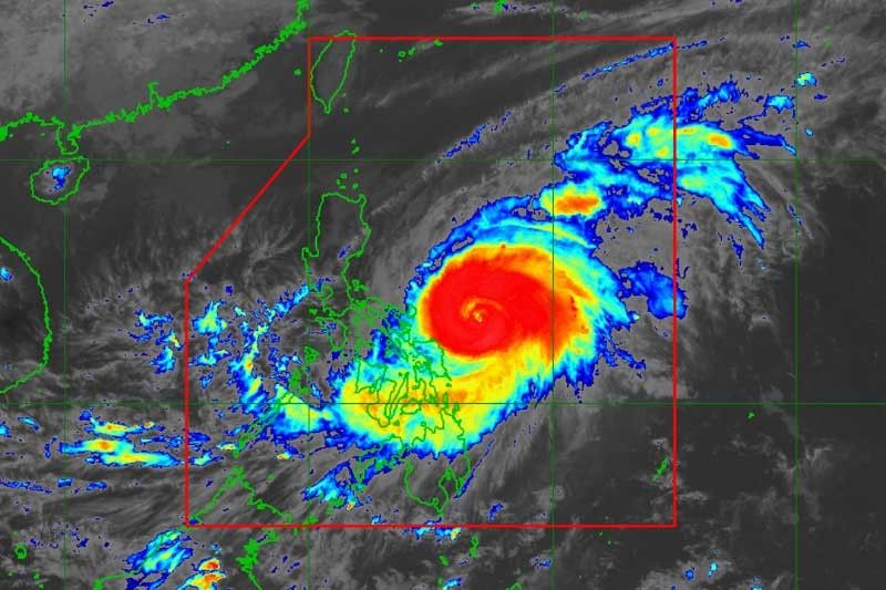
CEBU, Philippines — Typhoon Bising will continue to bring rain to Cebu as more local government units in the island were placed under Tropical Cyclone Warning Signal 1 according to PAGASA Severe Weather Bulletin 9 issued at 5 p.m. on Sunday, April 18, 2021.
Signal Number 1 was hoisted over Tabogon, Borbon, San Remigio, Bogo City, Medellin, Daanbantayan, Bantayan Island, and Camotes Islands.
PAGASA said areas effects in areas under signal number one may include very light or no damage to low risk structures; light damage to medium to high risk structures; and slight damage to some houses of very light materials or makeshift structures in exposed communities.
Wind and rain may also damage trees slightly but rice crops may incur significant damage when in the flowering stage.
Due to Typhoon Bising, 280 passengers and 134 vessels and rolling cargoes were stranded in northern and central Cebu while two vessels took shelter.
Because of strong winds, a fishing boat capsized with two of its passengers, both fishermen, in Looc, San Remigio as it was heading to Bantayan Island. The boat capsized when it encountered strong currents and huge waves about 200 meters away from Looc.
Coast Guard Station Central Cebu acting commander Alvin Dagalea said the incident happened past midnight Sunday, April 18, 2021, less than an hour when they left shore at 11:30 p.m. Saturday.
The fishermen, Redemptor Cueva, 54, and Archie Mamposte, 25, are safe after they managed to swim back to shore. Coast Guard personnel also recovered their fishing boat.
Cueva and Mamposte are residents of Banitugan in Bantayan Island.
Sunday forecast
PAGASA-Visayas weather specialist 1 Enzo Puerto said Cebu can see improvement of its weather condition by April 22 although based on tracking position, Typhoon Bising will still be in the Philippine Area of Responsibility until April 23.
As of Sunday, Typhoon Bising weakens slightly while moving west northwestward over the Philippine Sea East of Catanduanes. It will move northward until Tuesday, April 20, 2021, in the afternoon before turning north northwestward while over the Philippine Sea east of Cagayan Valley.
By Wednesday early morning, the typhoon is forecast to turn northeastward or east northeastward away from the landmass of Luzon.
“Considering the uncertainty in the track forecast of the typhoon, a westward shift in the current forecast track may result in potentially significant impacts over the eastern portions of Southern Luzon and Visayas. The possibility of a close approach scenario is not ruled out,” PAGASA said. — JMO (FREEMAN)
- Latest


