Enforcement of UNCLOS tribunal award by world naval powers

(Part II)
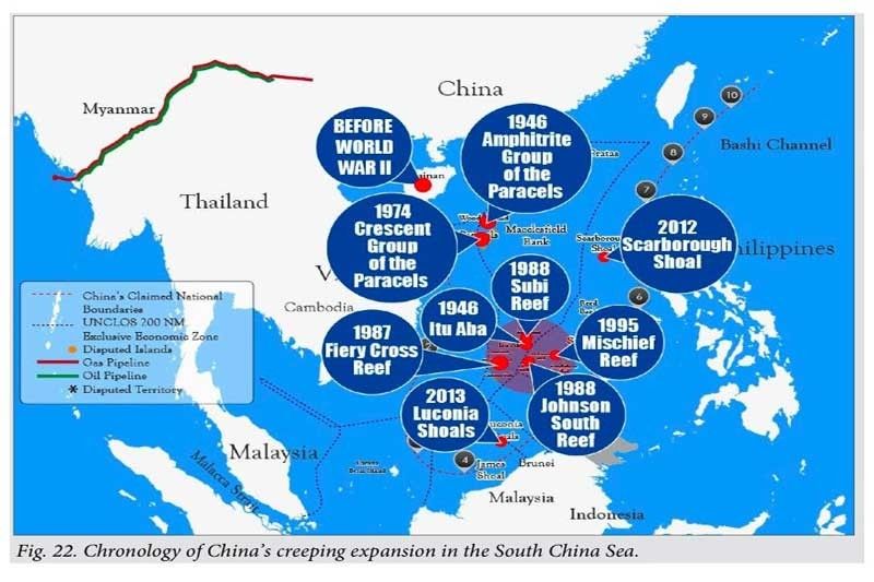
Before World War II, China’s southernmost defense perimeter was Hainan Island. Before the war, China did not have a single soldier or sailor stationed in any island in the South China Sea other than in Hainan Island. China’s creeping expansion began in 1946, right after the war, following the defeat of the Japanese, moving China’s defense perimeter southward. The following year in 1947, China forcible dislodged the South Vietnamese from the Crescent Group of the Paracels.
In 1987, China occupied Fiery Cross Reef on the pretext of building a weather radar station to assist UNESCO in its global oceanic survey but in 2014-2015 China reclaimed Fiery Cross Reef into a 270-hectare island, hosting a military airbase with a three-kilometer military grade runway and a seaport. In 1988, China forcibly evicted Vietnam from Johnson South Reef, moving further south China’s defense perimeter in the Spratlys. Also in the same year China seized Subi Reef from the Philippines by erecting a radar structure and military facilities on the reef. Subi Reef forms part of Palawan’s continental shelf where Tubattaha Reef, one of the five Philippine International Heritage sites is. Moreover China dredged Mischief Reef, located 125 miles from Palawan and created a 590-hectare artificial island, hosting an air-and-naval base with a three-kilometer military grade runway. Under the United Nations Convention on the Law of the Sea (UNCLOS), only the Philippines can erect structures or create an artificial island on Subi Reef and Mischief Reef. Thus, China and the Philippines, which have both ratified UNCLOS, have the obligation to comply in good faith with the Award.
The Murillo-Velarde map ‘Mother of all Philippine maps’
An official replica of the priceless Carta Hydrographica y Chorographica de la Yslas Filipinas Manila 1734, also known as the Murillo-Velarde map, which is regarded as the “mother of all Philippine maps” was turned over by IT entrepreneur and philanthropist Mel Velarde to the DFA Secretary in a simple ceremony at the Office of the Secretary, DFA Building on May 30, 2017. Mel Velarde bidded for the 1734 Murillo-Velarde map and donated it to the Filipino people to show the world that Scarborough Shoal and Spratlys were part of the Philippine territory since 1734.
Considered as the “holy grail” of Philippine cartography, the 1734 Murillo-Velarde map shows the entire Philippine archipelago in such detail that it is regarded as the first ever, scientific map of the Philippines. The map was named after the Spanish Jesuit friar Pedro Murillo Velarde who prepared it with the help of two Filipinos, Francisco Suarez, who drew the map, and Nicolas dela Cruz Bagay, who engraved it. The Murillo-Velarde map, as historic artifact, was cited in the Philippine complaint against China at the UNCLOS.
Enforcement of the award by world naval powers
The world naval powers will enforce the Award by sailing and flying and conducting military activities, in the high seas and EEZs of the South China Sea: The US has declared that its military forces will continue to operate in the South China Sea in accordance with international law. The US Chief of Naval Operations John Richardson stated, “The US Navy will continue to conduct routine and lawful operations around the world, including in the South China Sea, in order to protect the rights, freedom and lawful uses of sea and airspace guaranteed to all. This will not change.”
France has urged the 27-nation European Union to coordinate naval patrols in the South China Sea to ensure a “regular and visible” presence in the disputed waters illegally claimed by China. French Defense Minister Jean-Yves Le Drian said that the protection of freedom of the seas is vital from an economic standpoint and is concerned a loss of this right in the South China Sea might lead to similar problems in the Arctic Ocean or Mediterranean Sea. Russia has recently adopted regulations requiring all foreign vessels to secure prior permission from Russia before sailing through its “water area” in the North Sea Route. Russia’s “water area” includes its EEZ.
British Ambassador to the US Kim Darroch disclosed that the British Typhoon fighter jets that visited Japan in October 2016 flew over the South China Sea in their return flight to assert the freedom of overflight. He added: “Certainly, as we bring our two new aircraft carriers on-stream in 2020. As we renew and update our defense forces, they will be seen in the Pacific. We absolutely share the objective of this US administration, and the next one, to protect freedom of navigation and to keep sea routes and air routes open.
100 purposeful leaders
Akademyang Filipino paved the way to defend the Philippines’ sovereign rights in the West Philippine Sea. Only true and determined leaders including the youth can enforce the arbitral ruling contrary to President Rodrigo Roa Duterte’s stance of appeasement. Daily we pledge ourselves to defend our rights: LAND OF THE MORNING child of the sun returning, with fervor burning, Thee do our souls adore. Land dear and holy, cradle of noble heroes, ne’er shall invaders trample thy sacred shore. Ever within the skies and through thy clouds and o’er thy hills and sea do we behold the radiance, feel the throb of glorious liberty. Thy banner dear to all our hearts, its sun and stars alight, O never shall its shining field be dimmed by tyrant’s might! Beautiful land of love, o land of light in thine embrace ‘tis rapture to lie. But it is glory ever, when thou art wronged, for us, thy sons to suffer and die.”
(Reference: “The South China Sea Dispute…” eBook by Justice Antonio Carpio)
- Latest


