Signal No. 1 hoisted over Samar, Bicol as 'Nona' looms
MANILA, Philippines (First published 9:38 a.m.) — Tropical Storm Nona continued to gain strength midday on Sunday as it approaches the Philippines's land mass, threatening the Samar-Bicol area.
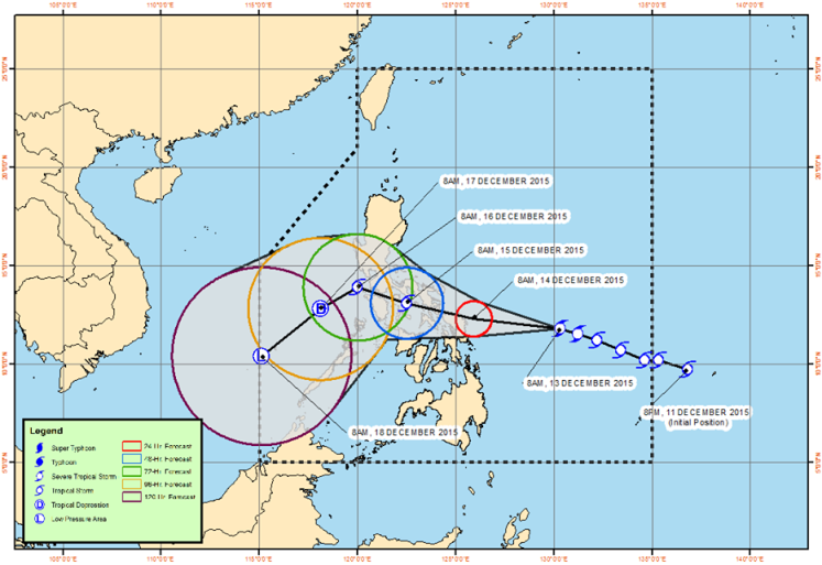
In an 11 a.m. advisory, state weather bureau PAGASA said the center of Nona, with international name "Melor," was spotted 565 kilometers east of Catarman, Northern Samar.
Nona intensified with maximum winds of 110 kilometers per hour (kph) near the center with gusts of up to 140 kph.

Forecast track of tropical Storm Nona as of Sunday, 11 a.m. PAGASA
LIVE updates: Tropical cyclone 'Nona'
PAGASA raised a Public Storm Warning Signal No. 1 over the following areas:
- Catanduanes
- Camarines Sur
- Albay
- Sorsogon
- Masbate
- Burias Islands
- Ticao Islands
- Northern Samar
- Eastern Samar
- Samar
- Biliran
- Leyte
- Southern Leyte
- Dinagat province
PAGASA said public storm warning signals are also expected to be raised over Camarines Norte, Southern Quezon, Marinduque and Romblon tonight.
The weather event is expected to move west northwest at 19 kilometers toward east of Catarman, Northern Samar in 24 hours. It will also likely head 65 kilometers the north of Romblon or at 150 kilometers east southeast of Calapan City in Oriental Mindoro on Tuesday morning.
AccuWeather meteorologist Evan Duffey said environmental conditions along the track of Nona are expected to allow it to strengthen into a typhoon.
"Melor will bring strong winds to the central Philippines, along with torrential rainfall and storm surge," Duffey said in a post Sunday (Philippine time).
Manila will be also potentially affected by heavy rains as it is likely to make a landfall in southern Luzon.
"While the system will be strong upon reaching the Philippines, it certainly won't be the strongest system that has hit the area this year," Duffey said. — Rosette Adel
- Latest
- Trending


