City beautiful: Davao eagle, People’s Park & durian dome

This week we continue our series on Philippine plazas and parks with more on Davao City’s public realm. Last week we featured Magsaysay Park located on Davao’s waterfront. From there we move to a cluster of open spaces in the city’s civic core, along with the city’s largest green oasis, People’s Park, nearby.
Davao’s urban pattern evolved late in the late Spanish colonial era. Mindanao was the edge of Spanish colonialism until the 1800s. It was only in1844 that Spanish General Agustin Bocallan claimed the site for the Spanish Crown. A settlement of 70 people was established a few years later. It was named Nueva Vergara after the Spanish hometown of the group’s leader, Jo?e Cruz de Oyanguren.
The town was built according to the Laws of the Indies pattern close to the original pre-Spanish settlement. Gleaning from the existing pattern, there appears to have been a large commons about three hectares defined by the church, a municipio, houses and a nearby market.
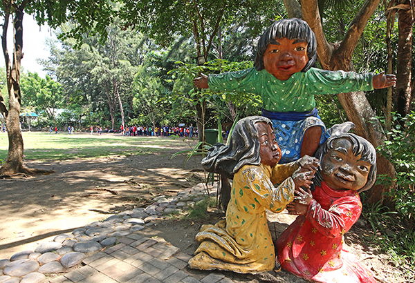
Artwork adorn People Park’s playfields and playgrounds.
The town expanded in the early American period as the fertile land lent itself to large plantations. Labor was short, which triggered a wave of migration from the Visayas and Luzon, including many Japanese (who had worked in numbers on the railroad to Baguio).
The Bureau of Public Works prepared a master plan that included port improvements. William E. Parsons, chief consulting architect of the bureau, laid out a “City Beautiful” pattern that framed the future city in a system of wide avenues and boulevards. The layout involved a distinctive diagonal grid of streets that extended from the original site near the river.
Parsons laid out a wide central spine, today’s Roxas Blvd., which connected the waterfront with an inner core meant for national government offices. A system of parks was also planned, with a large green area at the waterfront. This was never built. After the war, the project was revived and was to be named Quezon Park. It was never constructed and only the Magsaysay Park (which we featured last week), at the northern edge of the proposed waterfront esplanade, was built.
The further growth of the town led to its being chartered as a city in 1936. It was the first of two towns converted to cities in Mindanao, the other one being Zamboanga (whose plaza we will feature in a future article).
The new city upgraded its elegant municipal hall, originally built in 1926, into the city hall. Fronting the city hall is a 1,600 square meter plaza, which was eventually named Quezon Park. The space is technically a plaza since it is more paved area than green. Today it hosts two fountains featuring durians, the iconic fruit of city.
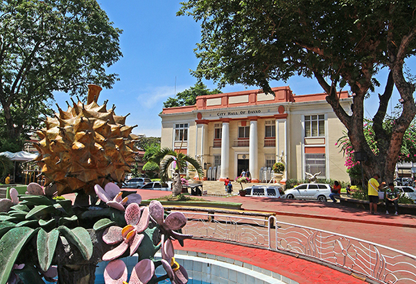
Durian fountains adorn Quezon Park in front of the old Davao City Hall.
Beside the city hall and Quezon Park is a larger space called Rizal Park for the memorial to the national hero located there. Again, this space is technically a plaza more than a park, since almost the whole area is paved. Opposite the monument is a large pavilion shaped like an eagle, the other icon of the city. The park is Davao’s kilometer zero, where all other destinations in the metropolis are measured.
Opposite the two parks is the San Pedro Church, which was first built in 1847 of light materials and is the oldest landmark of the area. It was rebuilt in wood in the American era and was modernized into a concrete structure a few decades ago. The design of the conservative façade of the early 20th century is attributed to an architect named Ramon Basa, while the modernist concrete structure we see today is by Manuel Chiew. Now designated a cathedral, the present design reminds me of Le Corbusier’s famous Notre Dame du Haut in Ronchamp, France.
The space opposite the cathedral was apparently a large open green area cumulatively known as Plaza de Oyanguren, to honor the founder of the settlement. The space immediately in front of the cathedral eventually was appropriated for the Sangguniang Panglungsod ng Dabaw (City Council of Davao). The remaining area is now Osmeña Park, which covers over six thousand square meters. More green and landscaped gardens than paving, this is an actual park in form and function.
A few blocks away from this cluster of civic spaces is an even larger park. People’s Park is a four-hectare cultural and recreational facility, a project of then Mayor Rodrigo Duterte from a decade ago. He repurposed the Philippine Tourism Authority’s defunct Palaruang Panlunsod. The city spent 72 million pesos for the project, inaugurating it in December of 2007.
The park’s entrance is anchored by a durian dome, which is a visitor center, and a large eagle sculpture, a popular spot for selfies. The park has a good balance of open green areas, jogging paths, playgrounds for kids, a senior’s corner, several water features, bamboo and themed gardens and a sloped corner planted to Benguet pine trees imported from Baguio.
I would rate the two plazas (Quezon and Rizal) above both 7.5 out of 10. The plaza designs could be rationalized and the two even integrated functionally into a larger space by appropriating the street in between them, along with portions of historic San Pedro Street.
I would rate Osmeña and People’s Parks at 8 to 8.5 out of 10. These spaces have a good size and a full range of amenities to cater to both passive and active recreation. Maintenance is adequate, although portions are showing wear and tear.
Davaeños obviously love these four open and green spaces. The plazas and parks are central to regular civic events, like the Kadayawan Festival, and contribute greatly to the city’s sense of community and identity. As the metropolis expands, however, there seems to be a lack of planning for additional public, open and green spaces. In a future ruled by climate change and disaster risk adaptation, these spaces are important elements necessary to balance rapid urban development.
* * *
Feedback is welcome. Please email the writer at paulo.alcazaren@gmail.com.


