Plaza Independencia connects modern Cebu to its cultural heritage

Last week we took a stroll in and around Plaza Sugbo in front of the Cebu City Hall. This week we continue with our series on Philippine plazas and parks with a feature on Plaza Independencia, two blocks east of Plaza Sugbo.
Plaza Independencia is the oldest and largest civic space of the city. It was and still is defined on one side by the triangular Fort San Pedro, to the north by the old Gobierno Provincial (now gone and replaced by commercial buildings), and to the south by the waterside. This edge has, since the American period, been the site of the Custom’s House and the city’s post office.
The plaza has had a long history and in fact was known by several names. In the 1600s, it was originally called Plaza de Armas. Within a century it expanded and was indicated in maps of the era as the Plaza Mayor. Later in the Spanish colonial era it was renamed Plaza Plaza Maria Cristina. This was to honor the queen regent of Spain. When the Americans took over it became Plaza Libertad, finally morphing into Plaza Independencia before the war.
The area of the plaza has also changed since the 1600s. Today it is about four hectares. This space had been kept largely open, from its historical origins around Fort San Pedro in the 17th century, to today. The original palisades were established in the late 1600s but the stone fort that stands to this day was from the early 18th century.
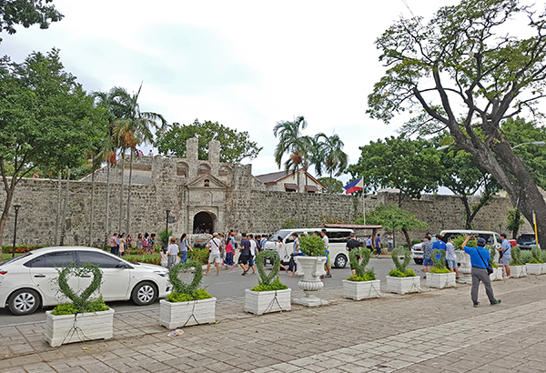
Fort San Pedro is the key landmark of, and largest element in, the plaza complex. Although it is low (its turrets are only 30 feet high), its mass dominates the landscape. Thankfully no skyscraper is photobombing the landmark. Some structures behind it and adjacent to Pier 1 come quite close. They actually cover whatever views of the sea the fort used to have in the first 300 years of its existence.
The three-sided fort is accessed on the east side fronting the plaza. I remember visiting this as a child, noting it was much smaller compared to Fort Santiago in Manila. Cebu also did not build a walled city, possibly because the Spanish population was also smaller than the national capital.

A pedestrian forecourt for Fort San Pedro would recover its lost dignity and scale that is today disrupted by tourist buses, cars and parking.
The fort was home to the Spanish garrison until the American period when it became the Warwick Barracks for their army. It was converted into a school in the commonwealth period. After the war it was home to the Philippine Army for a short spell.
In the 1950s it was turned over to the city as the fort itself slowly crumbled from age and lack of maintenance. The Cebu Garden Club turned the interiors into a garden and it was also a zoo. There was a move to demolish the fort in the late ’50s. Thankfully citizens opposed the initiative and the structure was saved.
In the 1960s the fort started to really deteriorate. Local and national tourism authorities partnered with the local Zonta Club to fund the restoration of the fort. The heritage consultant was architect Leonardo Concepción, the first graduate of the University of the Philippine architecture program in 1960, who completed his masters in conservation in Spain. The project took a while but by the 1970s the fort and Plaza Independencia were consolidated into a major tourist attraction for the city.
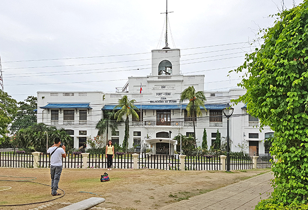
The Customs House at the eastern edge of the plaza is an American-era landmark. It was designed by William E. Parsons from a common template (the Iloilo Customs House is a twin). The structure was completed in 1910 and was in continuous use until the new millennium. In 2004, it was converted into the Malacanang of the South by then President Gloria Arroyo. It has not been used for that function since her term ended. It sits today separated from the plaza and should be functionally integrated with the plaza. It would make a wonderful boutique hotel or museum.
In 2006-2009 a tunnel was constructed underneath the plaza to connect the city to the new South Road Properties. In 2011 the plaza was reconfigured with a more contemporary abstract geometry in its paved and green areas. The main monument of Miguel Lopez de Legaspi and the formal fountain were left in their original locations.

The Malacañang sa Sugbo or old Customs House remains unused and could be turned into a museum or hotel.
I prefer a more traditional pattern for the plaza although the original layout has devolved since the late1950s with the additions of monuments to Legazpi, Pigafetta, Ramon Magsaysay and the War Veterans. Like many plazas nationwide this accretion of memorials and statuary are a reflection of Filipino horror vacuii or the fear of open spaces.
I would rate Plaza Independencia a 7 out of 10. It is big, but there are numerous unconnected elements within the plaza. These are not helped by the paving geometry that deconstructs the original spatial order, disrupts visual connections and gives little clues as to the historic genesis of importance of the place.
The plaza also has much to be desired as a civic space that relates weakly to its context. Cebu’s downtown is an uneven mix of heritage and almost forgotten modernity, abandoned for the shiny new mix-used developments elsewhere in the metropolis. Any intervention aimed at correcting the deficiencies of the plaza must address context and connectivity. It must look at the wider project and larger scale of the entire downtown district.
Every time I revisit the area, I keep thinking that the city and its citizens would do well to rediscover its origins via this key space, to appreciate its urban history through conserved and functionally re-adapted landmarks, and to reconnect with the waterside that defined Cebu City’s fate for centuries.
Modern Cebu City may be, but that modernity can be numbingly boring and faceless unless tempered by cultural specificity and place-based heritage.
Feedback is welcome. Please e-mail the writer at paulo.alcazaren@gmail.com.


