Signal No. 1 raised over Kalayaan Islands amid tropical depression ‘Romina'
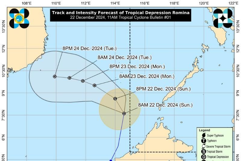
MANILA, Philippines (UPDATED 5:29 p.m.) — The state weather bureau, PAGASA, raised Tropical Cyclone Wind Signal No. 1 over the Kalayaan Islands on Sunday, December 22, as Tropical Depression Romina continues to move north northeastward toward the Southern Kalayaan Islands.
As of 11 a.m., Romina's was estimated 365 kilometers south of Pag-asa Island, Kalayaan, Palawan (Outside Philippine area of responsibility), moving north-northeastward by 30 kilometers per hour (kph). It packs maximum sustained winds of 55 kph near the center and gusts of up to 70 kph.
According to the state weather bureau, wind Signal No. 1 indicates potential minimal to minor impacts from strong winds, particularly in coastal and upland areas exposed to prevailing wind directions.
Winds are expected to be slightly stronger in these locations compared to more sheltered areas. The highest wind signal anticipated for Romina is Signal No. 2, should its intensity increase.
Hazards in Coastal Waters
Wave heights reaching up to 4.5 meters are expected in the seaboards of Batanes, Babuyan Islands, Ilocos Norte, and Kalayaan Islands, according to PAGASA.
Mariners are strongly advised to remain in port or, if already underway, to seek shelter immediately until weather conditions improve.
Other areas experiencing rough seas include:
- Up to 4.0 meters: Northern and eastern seaboards of Polillo Islands and Catanduanes; seaboards of Camarines Norte; northern seaboard of Camarines Sur.
- Up to 3.5 meters: Seaboards of mainland Cagayan, Isabela, Aurora, and northern mainland Quezon; eastern seaboards of Albay and Sorsogon; northern and eastern seaboards of Northern Samar; the remaining seaboard of Ilocos Region.
- Up to 3.0 meters: Western seaboard of Lubang Islands; eastern seaboard of Eastern Samar.
In regions with wave heights ranging from 2.0 to 2.5 meters, such as the eastern seaboards of Camarines Sur, Dinagat Islands, and Surigao del Sur, mariners are urged to exercise extreme caution. Areas like Zambales, Bataan, Batangas, Occidental Mindoro and Palawan may also experience similar conditions.
Operators of motorbancas and small vessels are recommended to avoid venturing out unless necessary and only with adequate preparations.
Track and Intensity Outlook
Currently moving north-northeast, Romina is forecast to turn north-northwestward later today and west-northwestward in the following days. It is projected to pass near the southern portion of the Kalayaan Islands within 24 hours.
While it may briefly strengthen into a tropical storm within the next 12 hours, it is expected to weaken into a tropical depression for the rest of its duration.
--
Editor's Note: An earlier version of this indicated that Romina is inside PAR. This has been updated to indicate the tropical depression is outside PAR.
- Latest
- Trending


