Super Typhoon Pepito poised for landfall, warnings intensify
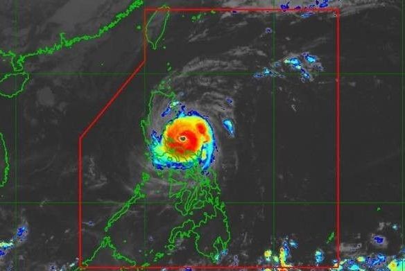
MANILA, Philippines — Super Typhoon “Pepito” (international name: Man-Yi) is bearing down on Luzon, with northern Quezon and parts of Aurora bracing for its devastating winds and torrential rains.
The storm, packing maximum sustained winds of 185 kilometers per hour (kph) and gusts reaching up to 255 kph, is expected to bring life-threatening conditions as it nears landfall, the state weather bureau Pagasa warned.
As of 8 a.m., Pepito was located over the coastal waters of Vinzons, Camarines Norte, moving northwest at 15 kph. Typhoon-force winds extend up to 300 kilometers from its center, prompting Pagasa to raise Tropical Cyclone Wind Signal No. 5 over parts of the Polillo and Calaguas Islands—areas facing an extreme threat to life and property within the next 12 hours.
Pagasa forecasts Pepito to make landfall over northern Quezon or central to southern Aurora between noon and early afternoon today. It is expected to cross Central and Northern Luzon, bringing destructive winds and heavy rains, before emerging over the West Philippine Sea later tonight or early tomorrow.
Tropical Cyclone Wind Signals
Signal No. 5
The state weather bureau has placed the eastern portion of the Polillo Islands (Patnanungan, Jomalig) and the Calaguas Islands under Tropical Cyclone Wind Signal No. 5. These areas face an imminent and extreme threat to life and property, with destructive winds exceeding 185 kph expected within 12 hours.
Signal No. 4:
The northernmost portion of Camarines Sur
- Siruma
The rest of Camarines Norte
The northern portion of mainland Quezon
- General Nakar
- Infanta
The rest of Polillo Islands
The central and southern portions of Aurora:
- Dingalan
- San Luis
- Maria Aurora
- Baler
- Dipaculao
- Dinalungan
The eastern portion of Nueva Ecija:
- General Tinio
- Gabaldon
- Laur
- Bongabon
- Palayan City
- Pantabangan
- Rizal
- General Mamerto Natividad
The southeastern portion of Nueva Vizcaya
- Alfonso Castañeda
The southern portion of Quirino
- Nagtipunan
Areas under signal no. 4 may expect typhoon-force winds, with speeds ranging from 118 to 184 kph with significant to severe danger to life and property within the next 12 hours.
Signal No. 3:
The northern portion of Camarines Sur:
- Sipocot
- Ragay
- Magarao
- Del Gallego
- Libmanan
- Naga City
- Bombon
- Lupi
- Cabusao
- Calabanga
- Goa
- San Jose
- Lagonoy
- Presentacion
- Caramoan
- Garchitorena
- Tinambac
- Canaman
- Camaligan
The western portion of Catanduanes:
- Caramoran
- Pandan
- San Andres
The eastern portion of Quezon:
- Calauag
- Guinayangan
- Tagkawayan
- Lopez
- Quezon
- Perez
- Alabat
- Gumaca
- Plaridel
- Atimonan
- Mauban
- Sampaloc
- Real
The eastern portion of Laguna:
- Santa Maria
- Famy
- Mabitac
- Pakil
- Pangil
- Siniloan
- Paete
- Kalayaan
- Lumban
- Cavinti
The eastern and central portions of Rizal:
- Pililla
- Tanay
- City of Antipolo
- Rodriguez
- Baras
- San Mateo
- Morong
- Teresa
The rest of Aurora
The eastern and central portions of Bulacan:
- Norzagaray
- San Miguel
- San Ildefonso
- San Rafael
- Doña Remedios Trinidad
- Angat
- City of San Jose del Monte
- Santa Maria
- Pandi
- Baliuag
- Bustos
- Pulilan
- Plaridel
The northeastern portion of Pampanga:
- Candaba
- Arayat
- Magalang
- San Luis
- San Simon
- Mexico
- Santa Ana
- Apalit
- Santo Tomas
- City of San Fernando
- Mabalacat City
- Angeles City
The rest of Nueva Ecija
Tarlac
The northern portion of Zambales:
- Santa Cruz
- Candelaria
- Masinloc
- Palauig
The rest of Nueva Vizcaya
The rest of Quirino
The southern portion of Isabela:
- San Agustin
- Jones
- Echague
- San Guillermo
- Angadanan
- Alicia
- San Mateo
- Ramon
- San Isidro
- City of Santiago
- Cordon
The central and southern portions of Ilocos Sur:
- Alilem
- Sugpon
- Cervantes
- Suyo
- Tagudin
- Narvacan
- Quirino
- Sigay
- Gregorio del Pilar
- San Emilio
- Santa Cruz
- Salcedo
- Banayoyo
- City of Candon
- Galimuyod
- Santa Lucia
- Lidlidda
- Santa Maria
- Burgos
- Santiago
- San Esteban
- Nagbukel
La Union
Pangasinan
Benguet
Ifugao
The western portion of Mountain Province:
- Sabangan
- Bauko
- Tadian
- Bontoc
- Sagada
- Besao
- Sadanga
- Barlig
The southern portion of Abra:
- Tubo
- Luba
- Pilar
- Villaviciosa
- San Isidro
Under signal no. 3, storm-force winds, with speeds ranging from 89 to 117 kph, pose a moderate to significant threat to life and property, with an 18-hour lead time for warnings.
Signal No. 2:
Albay
Northern portion of Marinduque
- Santa Cruz
- Boac
- Mogpog
- Torrijos
Rest of Quezon
Rest of Laguna
Rest of Rizal
Cavite
Northern portion of Batangas
- City of Tanauan
- Santo Tomas
- Talisay
- Lipa City
- Malvar
- Balete
- Mataasnakahoy
- Laurel
- Padre Garcia
- San Juan
- Rosario
Metro Manila
Bataan
Rest of Pampanga
Rest of Bulacan
Rest of Zambales
Southwestern portion of Cagayan
- Enrile
- Tuao
- Solana
- Tuguegarao City
- Piat
- Rizal
Rest of Isabela
Rest of Abra
Southern portion of Apayao
- Conner
- Kabugao
Kalinga
Rest of Mountain Province
Rest of Ilocos Sur
Southern portion of Ilocos Norte
- Pinili
- City of Batac
- Banna
- Nueva Era
- Badoc
- Currimao
- Marcos
- Solsona
- Dingras
- Sarrat
- Paoay
- Laoag City
- San Nicolas
Under signal no. 2 wind threat is gale-force winds, with a warning lead time of 24 hours, wind speeds ranging from 62 to 88 kph with potential for minor to moderate threats to life and property.
Signal no. 1:
- The northern portion of Masbate (City of Masbate, Mobo, Aroroy, Baleno), including Ticao and Burias Islands
- The rest of Marinduque
- The northern portion of Romblon (Cajidiocan, San Fernando, Magdiwang, Romblon, Banton, Corcuera, Concepcion, San Andres, Calatrava, San Agustin)
- The northern portion of Oriental Mindoro (Puerto Galera, San Teodoro, Naujan, Baco, Victoria, Socorro, Pinamalayan, Gloria, Pola, City of Calapan)
- The northern portion of Occidental Mindoro (Sablayan, Santa Cruz, Mamburao, Abra de Ilog, Paluan), including Lubang Islands
- The rest of Batangas
- The rest of mainland Cagayan
- The rest of Apayao
- The rest of Ilocos Norte
Under signal no. 1 strong winds are anticipated with a warning lead time of 36 hours, ranging from 39 to 61 kph which could pose a minimal to minor threat to life and property.
Coastal and marine hazards
According to Pagasa, coastal and marine hazards include a life-threatening storm surge exceeding three meters, which is possible in coastal areas of Ilocos, Isabela, Metro Manila, Central Luzon, CALABARZON, and Bicol.
Additionally, very rough seas with waves up to 14 meters are forecast along the seaboards of eastern Luzon.
The state weather bureau urged seafarers and marines to seek shelter due to a high-risk sea travel.
Forecast track
Pepito is anticipated to move west-northwestward over the waters north of Camarines provinces and east of Quezon this morning.
It will then pass close to or over Polillo Islands by late morning before making landfall over northern Quezon or central or southern Aurora between noon and afternoon.
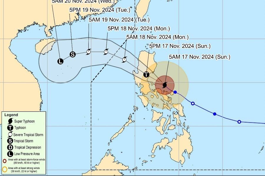
Afterward, Pepito will cross the northern portion of Central Luzon and the southern portion of Northern Luzon, along the upland areas of Sierra Madre, Caraballo, and Cordillera Central, between this afternoon and evening. The typhoon is expected to emerge over the coastal waters of Pangasinan or La Union tonight or early November 18.
Over the West Philippine Sea, Pepito will continue moving west-northwestward on Monday, November 18 and may exit the Philippine area of responsibility (PAR) by tomorrow morning or afternoon. Outside the PAR, the tropical cyclone will turn more westward or west-southwestward on Tuesday, November 19.
According to Pagasa, Pepito is expected to slightly weaken as a typhoon before its second landfall, with significant weakening anticipated as it moves over mainland Luzon today. It may weaken into a severe tropical storm over mainland Luzon, with further weakening likely over the West Philippine Sea due to the incoming northeasterly wind surge.
- Latest
- Trending


