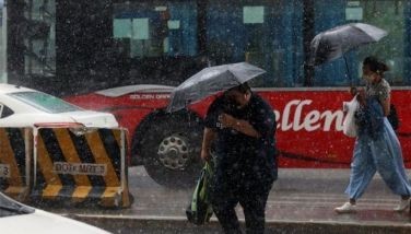
Signal No. 3 up over 6 areas as ‘Pepito’ nears super typhoon strength
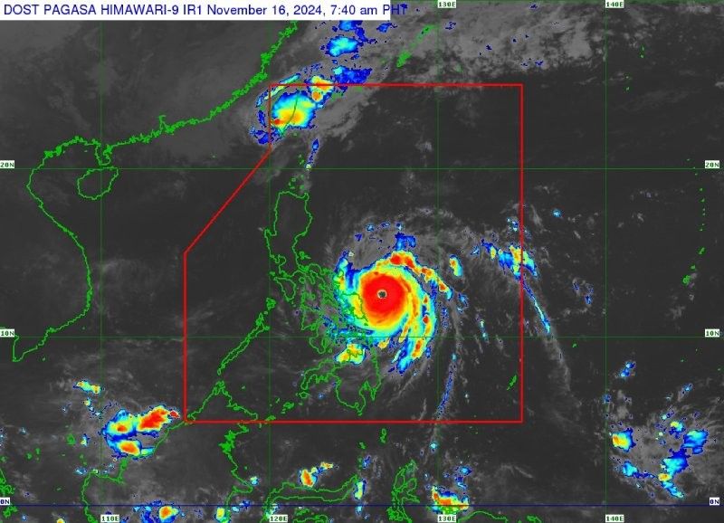
MANILA, Philippines — Typhoon Pepito (Man-Yi) is rapidly intensifying as it approaches Southern Luzon and Eastern Visayas, with state weather bureau PAGASA warning that it may reach super typhoon status before making landfall.
As of 7 a.m. on Saturday, November 16, Pepito was located 235 kilometers east of Catarman, Northern Samar.
It is carrying peak winds of 175 kilometers per hour near its center, gustiness of up to 215 kph and a central pressure of 940 hPa.
The typhoon is moving northwestward at 25 kph, with typhoon-force winds extending up to 440 kilometers from the center.
Wind signals
PAGASA raised tropical cyclone wind signals over the following areas:
Signal No. 3
Luzon
- Catanduanes
- eastern portion of Albay (Rapu-Rapu, Bacacay Santo Domingo, City of Tabaco, Malilipot, Tiwi, Malinao)
- eastern portion of Camarines Sur (Caramoan, Presentacion, San Jose, Garchitorena, Lagonoy, Sagñay, Tigaon, Goa, Tinambac, Siruma)
- easternmost portion of Sorsogon (Prieto Diaz)
Visayas
- eastern portion of Northern Samar (Palapag, Laoang, Mapanas, Gamay, Lapinig, Catubig, Pambujan)
- northernmost portion of Eastern Samar (San Policarpo, Arteche, Oras, Jipapad)
Signal No. 2
Luzon
- rest of Camarines Sur
- rest of Albay
- rest of Sorsogon
- Ticao Island
- Camarines Norte
- northeastern portion of Quezon (Perez, Alabat, Quezon, Calauag, Guinayangan, Tagkawayan) including Pollilo Islands
Visayas
- northern portion of Eastern Samar (Dolores, Maslog, Can-Avid, Taft, Sulat, San Julian, City of Borongan)
- northern portion of Samar (Matuguinao, Calbayog City, Santa Margarita, San Jorge, San Jose de Buan, Tarangnan, Motiong, Gandara, Jiabong, City of Catbalogan, Paranas, Hinabangan, San Sebastian, Pagsanghan)
- rest of Northern Samar
Signal No. 1
- rest of Masbate including Burias Island
- Marinduque
- Romblon
- rest of Quezon
- Laguna
- Rizal
- Cavite
- Batangas
- Metro Manila
- Zambales
- Bataan
- Bulacan
- Pampanga
- Tarlac
- Nueva Ecija
- Aurora
- Quirino
- Nueva Vizcaya
- Isabela
- mainland Cagayan
- Pangasinan
- La Union
- Ilocos Sur
- Ilocos Norte
- Abra
- Apayao
- Kalinga
- Mountain Province
- Ifugao
- Benguet
Visayas
- rest of Eastern Samar
- rest of Samar, Biliran
- northern and central portions of Leyte (Tunga, Pastrana, San Miguel, Matag-Ob, Tolosa, Palo, Calubian, Leyte, Mayorga, Julita, Carigara, Babatngon, Dagami, Jaro, San Isidro, Santa Fe, Albuera, Villaba, La Paz, Palompon, Macarthur, Tabontabon, Tanauan, Merida, Ormoc City, Isabel, Dulag, Capoocan, Alangalang, Burauen, Tabango, Tacloban City, Kananga, Barugo, Abuyog, Javier, City of Baybay, Mahaplag)
- northeastern portion of Southern Leyte (Silago)
- northernmost portion of Cebu (Daanbantayan, Medellin) including Bantayan Islands
- northernmost portion of Iloilo (Carles)
Mindanao
- northern portion of Dinagat Islands (Loreto, Tubajon)
Heavy rains, severe winds
Residents in affected areas are advised to prepare for heavy rainfall, which could lead to flooding and landslides, particularly in low-lying and mountainous regions.
PAGASA said the highest wind signal that may be hoisted due to Pepito is Signal No. 5.
Storm surge, sea conditions
The state weather agency issued a storm surge warning, with peak heights exceeding 3 meters expected in coastal areas, including Eastern Samar, Northern Samar, Bicol Region, Quezon, Metro Manila and parts of Central Luzon.
Sea conditions are expected to become very rough, with the Catanduanes seaboard expected to experience waves as high as 14 meters. Other areas such as the northern seaboard of Camarines Sur may see waves up to 12 meters, while the northern and eastern seaboards of Northern Samar could experience waves reaching 9 meters.
PAGASA warned that sea travel is hazardous for all types of vessels, especially in areas where waves could reach up to 7 meters along the eastern seaboards of Albay, Sorsogon, and Eastern Samar. Mariners are urged to follow the advisory and avoid venturing out to sea under these dangerous conditions.
Track, intensity outlook
Typhoon Pepito is expected to intensify further and may reach super typhoon status before making landfall on Saturday night or early Sunday morning.
PAGASA predicts landfall in Catanduanes but does not rule out other possible scenarios, including the eastern coasts of Camarines Sur, Albay, or Sorsogon.
The typhoon is expected to cross the Bicol Region, Quezon, Central Luzon provinces and parts of Northern Luzon before exiting the Philippine area of responsibility on Monday.
Pepito will likely weaken as it traverses land but will still pose significant threats in its path.
- Latest
- Trending


