'Nika' weakens as new threat 'Ofel' enters PAR
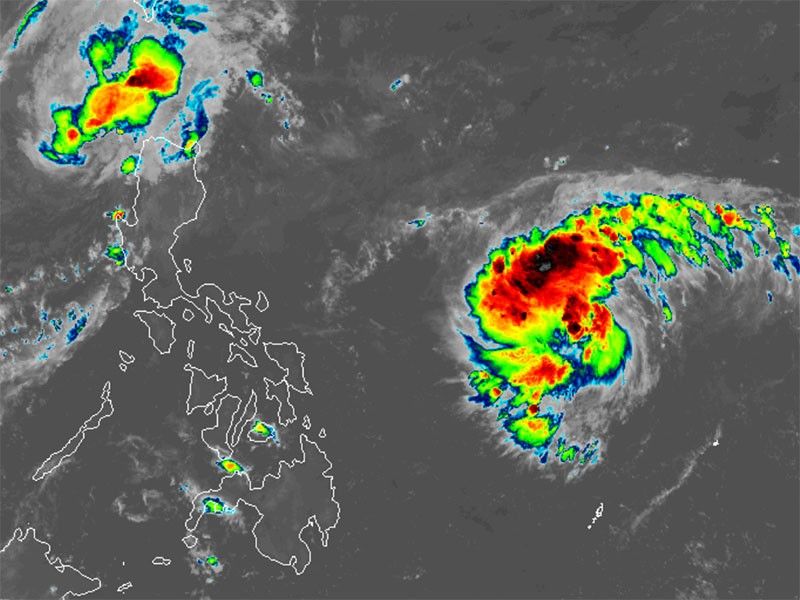
MANILA, Philippines — Just as Severe Tropical Storm Nika (international name: Toraji) begins to weaken over the West Philippine Sea, a new weather disturbance entered the Philippine area of responsibility (PAR) early Tuesday, November 12.
As of 4 a.m., PAGASA said Nika was spotted 185 kilometers west of Laoag City, Ilocos Norte, with peak winds of 95 kilometers per hour kilometers per hour near the center and gusts of up to 115 kph. The storm is moving northwest at a speed of 30 kph, pushing storm-force winds extending up to 320 km from its center.
The new storm, now named Ofel (international name: Usagi) was located approximately 1,170 kilometers east of southeastern Luzon, packing maximum sustained winds of 75 kilometers and gustiness of up to 90 kph. Ofel is moving west-northwestward at 25 kph, with strong to gale-force winds extending up to 230 kilometers from its center.
Wind signals
The state weather bureau hoisted Tropical Cyclone Wind Signal No. 1 over the following areas in Luzon due to Nika:
- Ilocos Norte
- northern portion of Ilocos Sur (Lidlidda, City of Candon, Galimuyod, Banayoyo, Burgos, Santiago, Santa Maria, San Esteban, Nagbukel, Narvacan, Caoayan, Santa, Bantay, City of Vigan, Santa Catalina, San Vicente, San Ildefonso, Santo Domingo, Magsingal, Cabugao, San Juan, Sinait)
- northern portion of Apayao (Kabugao, Pudtol, Luna, Santa Marcela, Calanasan, Flora)
- northern and western portions of Abra (Tineg, Lagangilang, Bucay, Villaviciosa, Lagayan, San Juan, La Paz, Danglas, Pilar, San Isidro, Peñarrubia, Tayum, Dolores, Bangued, Pidigan, Langiden, San Quintin)
- western portion of Babuyan Islands (Calayan Is., Dalupiri Is., Fuga Is.)
- northwestern portion of mainland Cagayan (Abulug, Pamplona, Sanchez-Mira, Santa Praxedes, Claveria)
Winds between 39 and 61 kph may be expected in at least 36 hours or intermittent rains may be expected within 36 hours. Minimal to minor impacts from strong winds are anticipated.
Heavy rains, severe winds
The combined effects of Nika and Ofel are expected to bring heavy rainfall across parts of northern Luzon.
PAGASA said Signal No. 1 may be raised in parts of Cagayan Valley by late Tuesday or early Wednesday, with a possible peak of Signal No. 4 as Ofel intensifies.
Strong to gale-force gusts from both the northeasterly wind flow due to Nika and Ofel will affect the following areas:
- Tuesday, November 12: Ilocos Sur, La Union, Pangasinan, Batanes, Cagayan, Babuyan Islands and Isabela
- Wednesday, November 13: Catanduanes
- Thursday, November 14: Batanes, Quezon, Polillo Islands, Camarines Norte, northern Camarines Sur and Catanduanes
- Friday, November 15: Isabela and northern Aurora
Storm surge, sea conditions
Coastal areas in Ilocos Norte and Ilocos Sur are at minimal to moderate risk of storm surge in the next 48 hours due to the combined effects of Nika and Ofel.
PAGASA raised a gale warning over the northern and western seaboards of northern Luzon.
It also issued warnings for dangerous sea conditions as Nika and Ofel affect coastal areas.
Nika is causing rough seas with waves up to 4.5 meters along the seaboards of Ilocos Norte and northern Ilocos Sur. Rough seas are also expected in Batanes, Cagayan and Babuyan Islands, with waves up to 3.5 meters.
Ofel is bringing rough seas to northern Aurora and northern Zambales, with waves up to 2.5 meters, and moderate seas to other parts of Luzon, Visayas and Mindanao.
PAGASA has advised mariners to seek shelter and stay in port, as sea travel is discouraged and could be dangerous in these areas.
Track, intensity outlook
Severe Tropical Storm Nika is expected to leave the Philippine area of responsibility (PAR) within the next 12 hours as it moves northwest over the West Philippine Sea, according to PAGASA.
While Nika will weaken in the coming days, it will remain a severe tropical storm until it reaches southern China.
Meanwhile, Tropical Storm Ofel is intensifying and could make landfall in northern or central Luzon by Thursday, November 14. It is expected to strengthen into a typhoon by Wednesday, November 13.
Although its exact landfall location is uncertain, northern Luzon is at risk for heavy rainfall, strong winds and possible storm surges. Central and southern Luzon could also be affected, especially if the storm takes a more southerly path.
- Latest
- Trending


