Weakened 'Marce' leaves landmass, now over Ilocos Norte waters
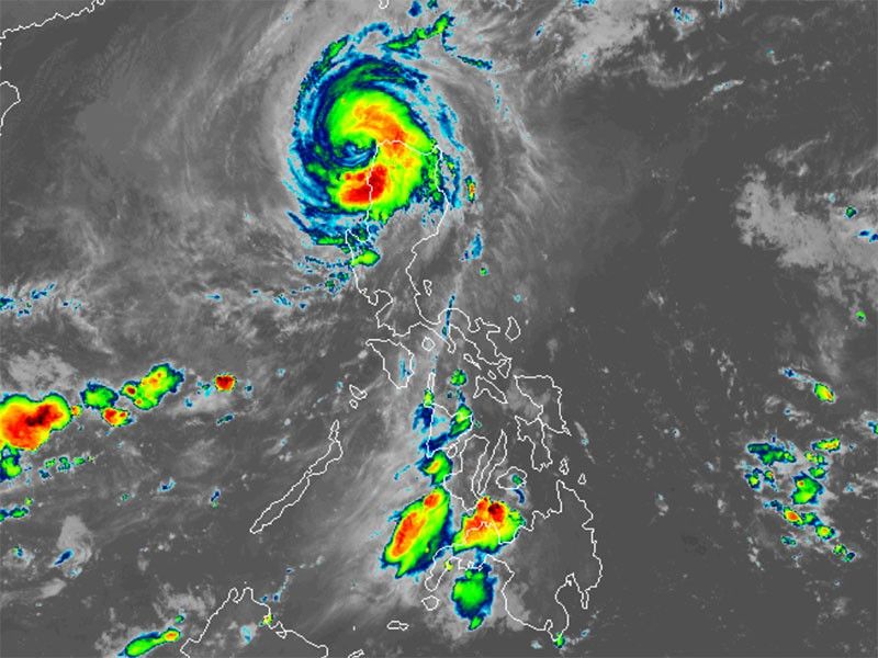
MANILA, Philippines — Typhoon Marce (international name: Yinxing) has weakened as it exited the landmass of northern Luzon and is now positioned over the coastal waters of Pasuquin, Ilocos Norte.
As of 4 a.m. on Friday, November 8, Marce was bearing maximum sustained winds reduced to 155 kilometers per hour and gusts reaching up to 215 kph.
Marce hit Cagayan twice on Thursday, November 7, making its first landfall in Santa Ana around 3:40 p.m. and a second in Sanchez-Mira by 9 p.m., according to PAGASA.
It is expected to exit the Philippine area of responsibility on Friday afternoon or evening.
Winds signals
The following areas in Luzon are under tropical cyclone wind signals:
Signal No. 4
- Ilocos Norte
- northernmost portion of Ilocos Sur (Sinait, Cabugao)
- northern portion of Abra (Danglas, Lagayan, Tineg)
- northwestern portion of Apayao (Calanasan)
- northwestern portion of mainland Cagayan (Sanchez-Mira, Claveria, Santa Praxedes)
Residents under Signal No. 4 may face a significant threat to life and property due to Marce's winds, which range from 118 kph to 184 kph.
Signal No. 3
- southern and western portion of Babuyan Islands (Fuga Is., Dalupiri Is., Calayan Is., Camiguin Is.)
- northern and western portions of Cagayan (Piat, Santo Niño, Rizal, Aparri, Lasam, Camalaniugan, Buguey, Santa Teresita, Allacapan, Pamplona, Abulug, Ballesteros)
- rest of Apayao
- central portion of Abra (Lacub, San Juan, La Paz, Bangued, Langiden, San Quintin, Pidigan, Malibcong, Peñarrubia, Bucay, Licuan-Baay, Lagangilang, Dolores, Tayum, Sallapadan, San Isidro)
- northern portion of Ilocos Sur (Santo Domingo, San Vicente, Santa Catalina, Bantay, San Ildefonso, City of Vigan, Caoayan, Santa, Narvacan, Nagbukel, Magsingal, San Juan)
Storm-force winds, ranging from 89 kph to 117 kph, may result in moderate to significant impacts in the areas
Signal No. 2
- southern portion of Batanes (Mahatao, Uyugan, Basco, Ivana, Sabtang)
- rest of Babuyan Islands
- rest of mainland Cagayan, the northern and western portions of Isabela (San Pablo, Santa Maria, Tumauini, Maconacon, Cabagan, Santo Tomas, Quezon, Mallig, Delfin Albano, Quirino, Gamu, Roxas, Burgos, Reina Mercedes, Luna, Aurora, San Manuel, San Mateo, Cabatuan)
- rest of Abra
- Kalinga
- Mountain Province
- northern portion of Ifugao (Alfonso Lista, Aguinaldo, Mayoyao, Banaue, Hungduan)
- northern portion of Benguet (Bakun, Mankayan)
- rest of Ilocos Sur
- northern portion of La Union (Sudipen, Bangar, Balaoan, Luna, Santol, Bacnotan)
Gale-force winds, ranging from 62 kph to 88 kph, could potentially cause minor to moderate impacts in the areas.
Signal No. 1
- rest of Batanes
- rest of La Union
- Pangasinan
- rest of Ifugao
- rest of Benguet
- rest of Isabela
- Quirino
- Nueva Vizcaya
- northern and central portions of Aurora (Dilasag, Casiguran, Dinalungan, Dipaculao)
- northern portion of Nueva Ecija (Carranglan)
- northern portion of Zambales (Santa Cruz, Candelaria)
Areas under Signal No. 1 may experience possible minimal to minor impacts from strong winds, ranging from 39 kph to 61 kph.
Severe winds
The state weather bureau said the northeasterly wind flow and the periphery of Marce is expected to bring strong to gale-force gusts over the following areas:
- Friday, November 8: Batanes, Cagayan including Babuyan Islands, Isabela and Ilocos Region.
- Saturday, November 9: Batanes and Babuyan Islands
Storm surge, sea conditions
PAGASA issued a storm surge warning for low-lying coastal areas in Batanes, Ilocos Norte, Cagayan and La Union, with surge heights expected to exceed 3 meters.
Gale warnings remain in effect for the seaboards of northern Luzon.
The public is warned of dangerous sea conditions, with travel posing risks for smaller vessels, such as motorbancas, in the following areas:
- Up to 12 meters: Seaboard of Babuyan Islands and Ilocos Norte
- Up to 8 meters: Seaboard of Ilocos Sur
- Up to 6 meters: Remaining seaboard of Ilocos Region; western seaboard of Batanes
- Up to 5 meters: Northern seaboard of mainland Cagayan; remaining seaboard of Batanes
- Up to 4.5 meters: Western seaboard of Pangasinan; remaining seaboard of mainland Cagayan.
- Up to 3.5 meters: Seaboard of Kalayaan Islands, Zambales and Isabela
- Up to 3 meters: Northeastern seaboard of Aurora; the western seaboard of Bataan, Lubang Islands, Calamian islands and mainland Palawan
- Up to 2.5 meters: Northern and eastern seaboards of Polillo Islands and Catanduanes; northern seaboard of Camarines Norte and Camarines Sur; northern and eastern seaboards of Northern Samar; eastern seaboards of Albay, Sorsogon, and Eastern Samar; western seaboard of Bataan; remaining seaboard of Aurora
- Up to 2 meters: Seaboards of Quezon; western seaboards of Occidental Mindoro and Batangas; eastern seaboards of Camarines Sur, Dinagat Islands and Surigao del Sur
Track, intensity outlook
PAGASA said Marce will continue weakening as it moves westward, with a possibility of further downgrading as it encounters dry air and prevailing northeasterly wind flow.
Marce is expected to keep its typhoon status until it leaves PAR later on Friday.
- Latest
- Trending


