'Marce' makes landfall in Cagayan with 'life-threatening conditions'

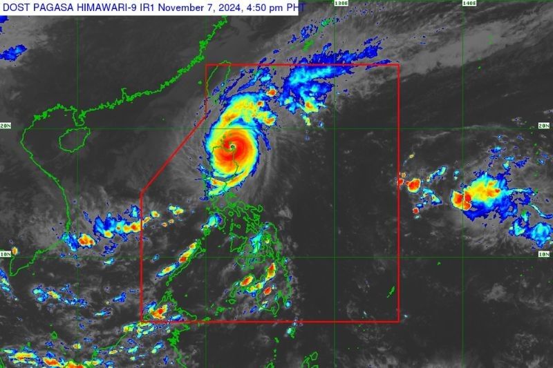
MANILA, Philippines — Typhoon Marce (international name: Yinxing) made landfall at 3:40 p.m. over Santa Ana, Cagayan with “life-threatening conditions” on Thursday afternoon, November 7.
In its 5 p.m. weather bulletin, PAGASA reported that Marce’s landfall will dump torrential rains in several areas in northern Luzon. These include Cagayan, Apayao, Ilocos Norte, Ilocos Sur and Abra.
The typhoon is carrying peak winds of 175 kilometers per hour (kph) and gusts of up to 240 kph, moving westward at the speed of 10 kph.
The state weather bureau said that Marce may become a super typhoon, but only for a brief period.
Wind signals
PAGASA placed the following areas under tropical cyclone wind signals:
Signal No. 4, typhoon-force winds (118 kph to 184 kph)
- northern portion of Cagayan (Gonzaga, Santa Ana, Santa Teresita, Lal-Lo, Buguey, Aparri, Camalaniugan, Gattaran, Ballesteros, Allacapan, Abulug, Pamplona, Sanchez-Mira, Claveria, Santa Praxedes, Lasam)
- Babuyan Islands
- northern portion of Apayao (Santa Marcela, Luna, Flora, Calanasan, Pudtol)
- northern portion of Ilocos Norte (Pagudpud, Bangui, Vintar, Dumalneg, Adams, Bacarra, Pasuquin, Burgos)
Signal No. 3, storm-force winds (89 kph to 117 kph)
- Batanes
- rest of Cagayan
- rest of Apayao
- rest of Ilocos Norte
- northern portion of Abra (Tineg, Danglas, Lagayan, Lacub, San Juan, La Paz, Bangued)
- northern portion of Ilocos Sur (Sinait, Cabugao, San Juan, Magsingal, Santo Domingo)
Signal No. 2, gale-force winds (62 kph to 88 kph)
- northern and central portions of Isabela (San Pablo, Santa Maria, Divilacan, Tumauini, Maconacon, Cabagan, Santo Tomas, Quezon, Palanan, Ilagan City, Mallig, Delfin Albano, Quirino, San Mariano, Gamu, Roxas, Naguilian, Burgos, Reina Mercedes, Benito Soliven, Luna, Aurora, San Manuel, San Mateo, Alicia, Angadanan, City of Cauayan, Cabatuan)
- rest of Abra
- Kalinga
- Mountain Province
- northern portion of Ifugao (Alfonso Lista, Aguinaldo, Mayoyao, Banaue, Hungduan)
- northern portion of Benguet (Bakun, Mankayan)
- rest of Ilocos Sur, and the northern portion of La Union (Sudipen, Bangar, Balaoan, Luna, Santol)
Signal No. 1, strong winds (39 kph to 61 kph)
- rest of La Union
- Pangasinan
- rest of Ifugao
- rest of Benguet
- rest of Isabela
- Quirino
- Nueva Vizcaya
- northern and central portions of Aurora (Dilasag, Casiguran, Dinalungan, Dipaculao, Maria Aurora, Baler)
- northern portion of Nueva Ecija (Carranglan)
- northern portion of Zambales (Santa Cruz, Candelaria)
Storm surge. PAGASA issued a warning for life-threatening storm surges, potentially exceeding 3.0 meters, in the next two days for the coastal areas of Batanes, Cagayan, Babuyan Islands, Isabela, Ilocos Norte, Ilocos Sur and La Union.
Forecast track

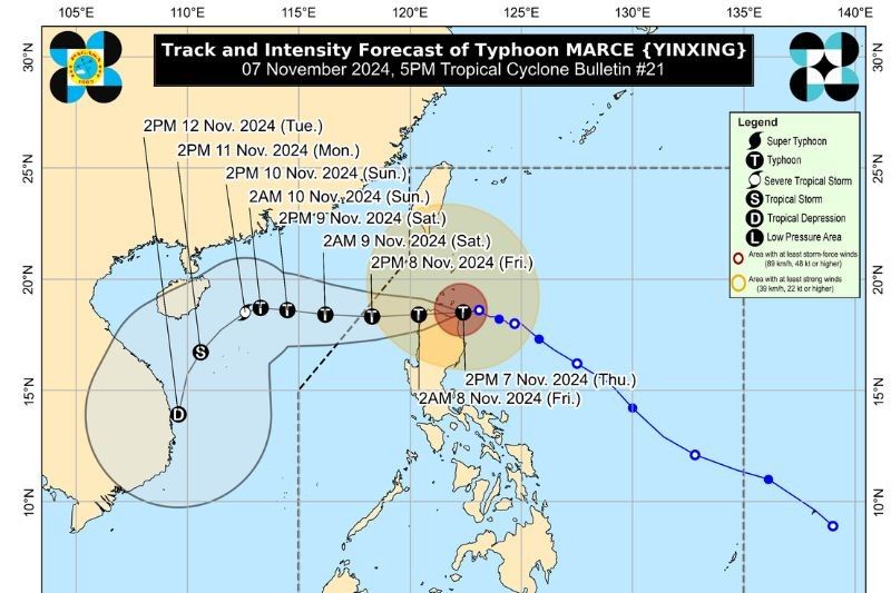
The state weather bureau is expecting Marce to move westward towards Aparri Bay and make another landfall along the coast of northwestern mainland Cagayan on Thursday night.
Marce is anticipated to leave the Philippine area of responsibility by Friday, November 8.
- Latest
- Trending


