Signal No. 4 still up in northern Luzon as 'Marce' approaches Babuyan Islands for landfall
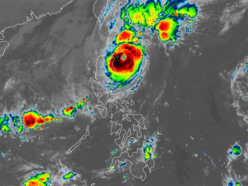
MANILA, Philippines — Two areas in northern Luzon remain under Signal No. 4 as Typhoon Marce (international name: Yinxing) is on track to make landfall over Babuyan Islands.
In its 5 a.m. weather bulletin, PAGASA said that Marce was spotted 210 kilometers east of Aparri, Cagayan.
Bearing peak winds of 155 kilometers per hour near its center, with gusts up to 190 kph, Marce is moving west-northwest at a speed of 15 kph.
Wind signals
PAGASA raised tropical cyclone wind signals over the following areas in Luzon:
Signal No. 4
- northeastern portion of mainland Cagayan (Gonzaga, Santa Ana, Santa Teresita, Lal-Lo, Buguey, Aparri, Camalaniugan)
- southeastern portion of Babuyan Islands (Camiguin Is.)
Residents here may face a significant threat to life and property due to Marce's winds, which range from 118 kph to 184 kph.
Signal No. 3
- southern portion of Batanes (Mahatao, Uyugan, Basco, Ivana, Sabtang)
- rest of Babuyan Islands
- rest of Cagayan
- Apayao
- northern portion of Ilocos Norte (Pagudpud, Dumalneg, Adams, Bangui, Burgos, Vintar, Carasi, Pasuquin)
Storm-force winds, ranging from 89 kph to 117 kph, may result in moderate to significant impacts in the area.
Signal No. 2
- rest of Batanes
- northern and central portions of Isabela (San Pablo, Santa Maria, Divilacan, Tumauini, Maconacon, Cabagan, Santo Tomas, Quezon, Palanan, Ilagan City, Mallig, Delfin Albano, Quirino, San Mariano, Gamu, Roxas, Naguilian, Burgos, Reina Mercedes, Benito Soliven, Luna, Aurora, San Manuel, San Mateo, Alicia, Angadanan, City of Cauayan, Cabatuan)
- Abra
- Kalinga
- Mountain Province
- northern portion of Ifugao (Alfonso Lista, Aguinaldo, Mayoyao, Banaue, Hungduan)
- rest of Ilocos Norte
- northern and central portions of Ilocos Sur (Sinait, Cabugao, San Juan, Magsingal, Santo Domingo, Bantay, San Ildefonso, San Vicente, Santa Catalina, City of Vigan, Narvacan, Caoayan, Santa, Nagbukel, Santa Maria, San Esteban, Santiago, Burgos, Banayoyo, Lidlidda, San Emilio, City of Candon, Salcedo, Galimuyod, Santa Lucia, Gregorio del Pilar, Quirino, Sigay, Cervantes, Suyo, Santa Cruz)
Gale-force winds, ranging from 62 kph to 88 kph, could potentially cause minor to moderate impacts in these areas.
Signal No. 1
- rest of Ilocos Sur
- La Union
- Pangasinan
- rest of Ifugao
- Benguet
- rest of Isabela
- Quirino
- Nueva Vizcaya
- northern and central portions of Aurora (Dilasag, Casiguran, Dinalungan, Dipaculao, Maria Aurora, Baler)
- northern portion of Nueva Ecija (Carranglan)
- northern portion of Zambales (Santa Cruz, Candelaria)
Areas under Signal No. 1 may experience possible minimal to minor impacts from strong winds, ranging from 39 kph to 61 kph.
Severe winds
PAGASA said the northeasterly wind flow and the periphery of Marce is expected to bring strong to gale-force gusts over the following areas:
- Thursday, November 7: Zambales, Bataan and Polillo Islands
- Friday, November 8: Batanes, Cagayan including Babuyan Islands, the eastern portion of Isabela and Ilocos Region
- Saturday, November 9: Batanes, Babuyan Islands and Ilocos Region
Storm surge, sea conditions
PAGASA issued a storm surge warning over several coastal areas, with peak surge levels potentially exceeding 3 meters in Batanes, Cagayan, Babuyan Islands and Ilocos provinces.
A gale warning is in effect for northern and central Luzon’s coastlines.
PAGASA warned mariners of dangerous sea conditions, warning that travel poses risks for smaller vessels, such as motorbancas, in the following areas:
- Up to 12 meters: Seaboard of Babuyan Islands, northern seaboard of mainland Cagayan
- Up to 10 meters: Northern seaboard of Ilocos Norte
- Up to 8 meters: Seaboard of Batanes; remaining seaboard of mainland Cagayan.
- Up to 7 meters: Remaining seaboard of Ilocos Norte; seaboard of Isabela
- Up to 6 meters: Seaboard of Ilocos Sur
- Up to 5 meters: Remaining seaboard of Ilocos Region
- Up to 4.5 meters: Seaboards of northern Zambales and northern Aurora
- Up to 4.5 meters: Seaboards of Kalayaan Islands
- Up to 3.5 meters: Northern and eastern seaboards of Polillo Islands; seaboards of Camarines Norte; northern seaboards of Catanduanes and Camarines Sur; remaining seaboard of Zambales.
- Up to 3 meters: Eastern seaboard of Catanduanes; Seaboard of northern Quezon
- Up to 2.5 meters: Northern and eastern seaboards of Northern Samar; eastern seaboards of Albay, Sorsogon, and Eastern Samar; western seaboards of Bataan, Lubang Islands, Palawan including Calamian Islands;
- Up to 2 meters: Western seaboards of Occidental Mindoro; eastern seaboard of Camarines Sur and Dinagat Islands
Track, intensity outlook
The state weather bureau said that Marce is set to make landfall over the Babuyan Islands or northern parts of Cagayan, Ilocos Norte and Apayao later on Thursday or Friday early morning.
It is expected to move west-northwest for the next 12 hours over the waters east of Cagayan before shifting westward from Thursday afternoon until Saturday.
While Marce is expected to maintain its strength for the next 12 hours, slight weakening is possible starting Thursday afternoon due to its interaction with the terrain of mainland Luzon.
The typhoon will remain within the Philippine area of responsibility (PAR) region and may weaken further over the weekend as the northeasterly wind flow increases.
Marce may exit PAR by Friday evening.
- Latest
- Trending


