Signal No. 2 still up in parts of northern Luzon as 'Marce' holds strength
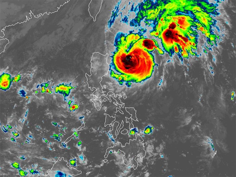
MANILA, Philippines — Two areas in northern Luzon remain under Signal No. 2 as Typhoon Marce (international name: Yinxing) maintains its strength over the Philippine Sea.
As of 4 a.m. on Tuesday, November 6, PAGASA said that Marce was located 345 kilometers east of Tuguegarao City, Cagayan.
It was carrying peak winds of 140 kilometers per hour and gusts reaching 170 kph.
Marce is advancing northwestward at a speed of 15 kph.
Wind signals
The state weather bureau hoisted the following tropical cyclone wind signals in several areas:
Signal No. 2
- eastern portion of Babuyan islands (Camiguin Is., Babuyan Is.,)
- northeastern portion of mainland Cagayan (Santa Ana, Gonzaga, Lal-Lo, Santa Teresita, Buguey)
Gale-force winds, ranging from 62 kph to 88 kph, could potentially cause minor to moderate impacts in these areas.
Signal No. 1
- Batanes
- rest of Cagayan including Babuyan Islands
- Ilocos Norte
- Ilocos Sur
- Apayao
- Abra
- Kalinga
- Mountain Province
- Ifugao
- northern portion of Benguet (Mankayan, Buguias, Kabayan, Bakun, Kibungan, Atok, Bokod)
- Isabela
- Nueva Vizcaya
- Quirino
- northern portion of Aurora (Dilasag, Casiguran, Dinalungan, Dipaculao, Baler, Maria Aurora)
Areas under Signal No. 1 may experience possible minimal to minor impacts from strong winds, ranging from 39 kph to 61 kph.
Severe winds
PAGASA said the highest wind signal that may be raised due to Marce is Signal No. 4.
The northeasterly wind flow is expected to bring strong to gale-force gusts over the following areas in the coming days:
- Wednesday, November 6: Ilocos Region, Quezon, Camarines Norte, Camarines Sur and Catanduanes
- Thursday, November 7: Ilocos Sur, La Union, Pangasinan, Aurora, Zambales, Quezon and Catanduanes
- Friday, November 8: Ilocos Region, Isabela, Aurora and Zambales
Storm surge, sea conditions
PAGASA issued a storm surge warning over several coastal areas, with waves expected to rise between 2 to 3 meters above the normal tide in low-lying regions of Batanes, Cagayan, Babuyan Islands, Isabela, Ilocos Norte and Ilocos Sur.
A gale warning remains in effect across the northern and eastern seaboards of Luzon.
The state weather bureau advised the public to avoid traveling by sea due to dangerous conditions in the following areas:
- Up to 8 meters: Seaboard of northeastern mainland Cagayan and eastern portion of Babuyan Islands
- Up to 7 meters: Remaining seaboards of Cagayan and Babuyan Islands
- Up to 6 meters: Northern seaboard of Ilocos Norte; seaboard of northeastern Isabela
- Up to 5.5 meters: Remaining seaboard of Ilocos Norte; seaboards of Ilocos Sur; western seaboard of Pangasinan; remaining seaboard of Isabela
- Up to 4.5 meters: Remaining seaboard of Ilocos Region; seaboard of northern Aurora
- Up to 4 meters: Seaboard of northern Zambales
- Up to 3.5 meters: Northern and eastern seaboard of Polillo Islands; seaboard of Camarines Norte; northern seaboard of Catanduanes
- Up to 3 meters: Northern seaboards of Camarines Sur; eastern seaboard of Catanduanes; remaining seaboard of Zambales
- Up to 2.5 meters: Eastern seaboards of Albay and Sorsogon; northern and eastern seaboards of Northern Samar and Eastern Samar; western seaboard of Bataan and Lubang Islands; seaboard of Kalayaan Islands
- Up to 2 meters: Western seaboards of Palawan including Calamian Islands; eastern seaboard of Camarines Sur, Eastern Samar, Dinagat Islands, Surigao del Sur and Davao Oriental
Track, intensity outlook
PAGASA said that Marce will move west-northwest on Wednesday, slowing down over the Philippine Sea east of northern Luzon.
The typhoon is expected to turn westward on Thursday as it nears the Babuyan Islands and northern Cagayan. It is likely to make landfall or pass close to these areas between Thursday afternoon and Friday morning.
Marce may exit the Philippine area of responsibility by Friday evening.
- Latest
- Trending


