Batanes downgraded to Signal No. 4 as 'Leon' keeps strength
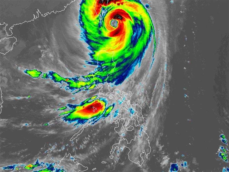
MANILA, Philippines — Batanes has been downgraded to Tropical Cyclone Wind Signal No. 4 as Super Typhoon Leon (international name: Kong-Rey) advances northwestward near Batanes.
As of 7 a.m. on Thursday, October 31, PAGASA reported that Leon was spotted 110 kilometers north-northeast of Itbayat, Batanes.
Super Typhoon Leon is carrying peak winds of 195 kilometers per hour near its center, with gusts reaching up to 240 kilometers per hour and a central pressure of 920 hPa.
Wind signals
The following areas are under tropical cyclone wind signals:
Signal No. 4
- Batanes
Residents here may face a significant threat to life and property due to Leon's winds, which range from 118 kph to 184 kph.
Signal No. 3
- northern portion of Babuyan Islands (Babuyan Is.)
Storm-force winds, ranging from 89 kph to 117 kph, may result in moderate to significant impacts in the area.
Signal No. 2
- rest of Babuyan Islands
- northern portion of mainland Cagayan (Camalaniugan, Lal-Lo, Pamplona, Gonzaga, Santa Teresita, Baggao, Buguey, Claveria, Gattaran, Lasam, Aparri, Ballesteros, Abulug, Allacapan, Sanchez-Mira, Santa Praxedes, Santa Ana)
- northern portion of Apayao (Pudtol, Luna, Santa Marcela, Calanasan, Flora)
- northern portion of Ilocos Norte (Sarrat, Piddig, Bangui, Vintar, Burgos, Pagudpud, Bacarra, Adams, Pasuquin, Carasi, San Nicolas, Dumalneg, Laoag City)
Gale-force winds, ranging from 62 kph to 88 kph, could potentially cause minor to moderate impacts in these areas.
Signal No. 1
- rest of Cagayan
- Isabela
- rest of Apayao
- Abra, Kalinga
- Mountain Province
- Ifugao
- northern portion of Benguet (Mankayan, Bakun, Buguias)
- rest of Ilocos Norte
- Ilocos Sur
Areas under Signal No. 1 may experience possible minimal to minor impacts from strong winds, ranging from 39 kph to 61 kph.
Severe winds
The state weather bureau reported that although no wind signals have been raised for the following areas, they will still experience "gusty conditions" on Thursday
- Most of Cordillera Administrative Region
- Quirino
- Nueva Vizcaya
- Aurora
- Bataan
- Metro Manila
- Calabarzon
- MIMAROPA
- Bicol Region
- Northern Samar
- most of Western Visayas.
The gusty conditions are expected to persist on Friday, November 1, affecting the following areas:
- Batanes
- Cagayan including Babuyan Islands
- Isabela
Storm surge, sea conditions
Residents of Batanes and the Babuyan Islands are facing a high risk of life-threatening storm surge within the next 48 hours, with wave heights expected to exceed 3 meters above normal tide levels.
A gale warning has been issued for the seaboard of Northern Luzon and the eastern seaboards of Central Luzon.
PAGASA advised mariners of dangerous sea conditions, warning that travel poses risks for smaller vessels, such as motorbancas, in the following areas:
- Up to 14 meters: Batanes seaboard
- Up to 12 meters: Babuyan Islands seaboard
- Up to 10 meters: Northeastern mainland Cagayan seaboard
- Up to 6 meters: Northern seaboard of Ilocos Norte, Isabela and remaining Cagayan seaboard
- Up to 5 meters: Northern Aurora seaboard
- Up to 4.5 meters: Remaining Ilocos Norte seaboard
- Up to 4 meters: Northern and eastern seaboards of Polillo Islands and Catanduanes, seaboards of Ilocos Sur and Camarines Norte and northern Camarines Sur
- Up to 3.5 meters: Remaining Ilocos Region and Aurora seaboards, northern and eastern Northern Samar, and eastern seaboards of Albay, Sorsogon and Eastern Samar
- Up to 3 meters: Eastern seaboards of Quezon (including the rest of Polillo Islands) and Dinagat Islands, western seaboard of Zambales
- Up to 2.5 meters: Western seaboards of Bataan, Batangas, Occidental Mindoro (including Lubang Islands), northern mainland Palawan and Calamian Islands
- Up to 2 meters: Remaining Luzon seaboards and those of Aklan and Capiz
Track, intensity outlook
PAGASA reported that Super Typhoon Leon is expected to make landfall on the eastern coast of Taiwan by Thursday afternoon.
After crossing Taiwan, the storm will move toward the East China Sea and exit the Philippine area of responsibility on Thursday night or Friday morning.
There is also a chance Leon could make a second landfall in mainland China.
The state weather bureau said that Leon has reached its peak intensity near Batanes but is predicted to weaken into a typhoon within the next 12 hours as it approaches Taiwan. Its interaction with the mountainous terrain there will likely lead to further weakening.
- Latest
- Trending


