‘Leon’ likely to become super typhoon on October 31 — PAGASA
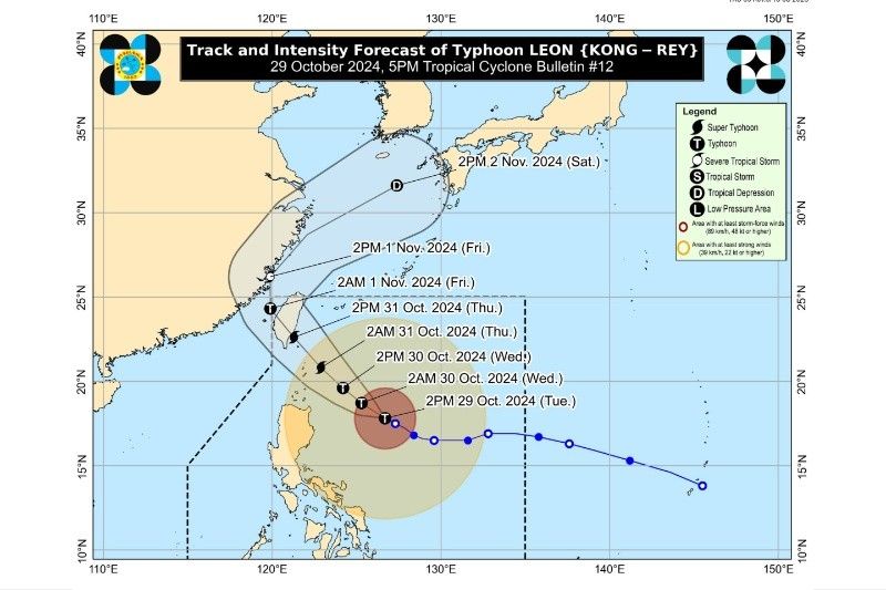
MANILA, Philippines — As Typhoon “Leon” (international name: Kong-Rey) intensifies, state weather bureau PAGASA said it is likely to become a super typhoon on Thursday, October 31.
In PAGASA's 5 p.m. bulletin on Tuesday, October 29, it said that Leon had undergone a “rapid intensification” over the waters east of Cagayan.
Leon was last located 505 kilometers (km) east of Tuguegarao City, Cagayan. It packs maximum sustained winds of 150 km per hour (kph) and gustiness up to 185 kph.
The typhoon is moving west-northwest at 10 kph, with winds extending up to 660 km from its center.
PAGASA has raised Tropical Cyclone Wind Signal (TCWS) no. 2 over the following areas:
- Batanes
- Babuyan Islands
- Mainland Cagayan
- Northern and Eastern Portions of Isabela
- Apayao
- Northern Portion of Kalinga
- Northern Portion of Abra
- Ilocos Norte
Areas under TCWS no. 2 are likely to experience gale-force winds with possible moderate threats to life and property.
Meanwhile, TCWS no. 1 has also been hoisted over the following areas:
- The rest of Isabela
- Quirino
- Nueva Vizcaya
- The rest of Kalinga
- Mountain Province
- Ifugao
- Benguet
- The rest of Abra
- Ilocos Sur
- La Union
- Eastern Portion of Nueva Ecija
- Aurora
- Northern and Eastern Portion of Quezon
- Polillo Islands
- Camarines Norte
- Camarines Sur
- Catanduanes
- Albay
- Northern Portion of Sorsogon
Severe winds, coastal hazards
Minor to moderate wind impacts are expected in areas under TCWS No. 2, while regions under TCWS No. 1 may face minimal to minor impacts.
Additionally, the typhoon’s circulation could bring gusty conditions across Metro Manila, Calabarzon, Mimaropa, Bicol, and parts of Visayas through Thursday.
PAGASA has issued a storm surge warning for Batanes and Babuyan Islands, with a high risk of life-threatening storm surges reaching two to three meters above normal tide levels.
Mariners are advised to avoid sea travel as rough to high seas, reaching up to 10 meters, are expected along the seaboards of Northern Luzon.
Track forecast
Leon is forecast to approach Batanes early Thursday, moving northwestward over the Philippine Sea.
PAGASA also predicts a landfall along Taiwan’s eastern coast on Thursday evening. The cyclone may later head towards the East China Sea before exiting the Philippine area of responsibility late Thursday or early Friday.
- Latest
- Trending


