'Julian' weakens into typhoon as it continues moving toward Taiwan

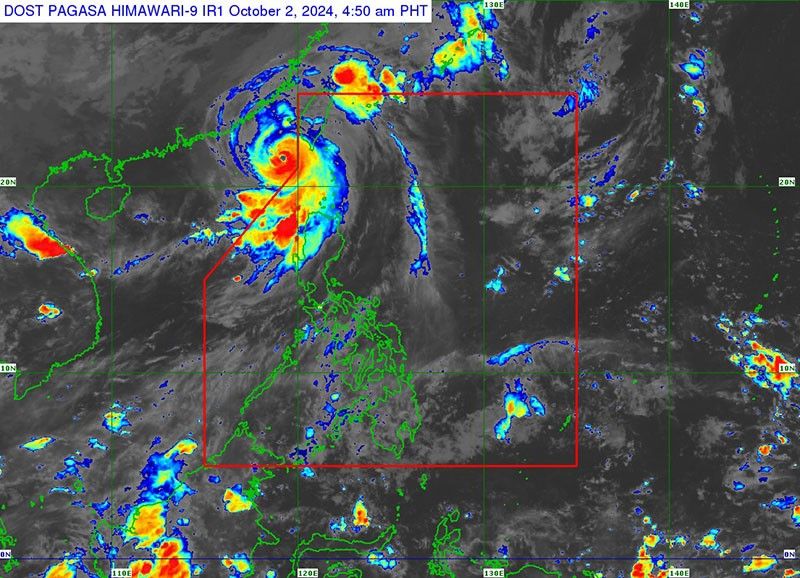
MANILA, Philippines — Tropical cyclone Julian (international name: Krathon) has weakened into a typhoon as it continues its path toward Taiwan, state weather bureau PAGASA reported on Wednesday, October 2.
As of 4 a.m., Julian was spotted 280 kilometers west-northwest of Itbayat, Batanes, now outside the Philippine area of responsibility.
Moving slowly northwest toward Taiwan, Julian was carrying peak winds of 165 kilometers per hour (kph) near its center, with gusts reaching up to 205 kph.
Wind signal
Parts of northern Luzon have been downgraded to Tropical Cyclone Wind Signal No. 1 as the tropical cyclone weakened into a typhoon. These areas include:
- Batanes
- Babuyan Islands
- northern
- western portions of Ilocos Norte (Pasuquin, Sarrat, Paoay, Bangui, Vintar, Burgos, Pagudpud, Bacarra, Currimao, Adams, Pinili, San Nicolas, Dumalneg, Laoag City, Badoc, City of Batac)
- northwestern portion of mainland Cagayan (Santa Praxedes, Sanchez-Mira, Claveria)
Winds between 39 and 61 kph may be expected in at least 36 hours or intermittent rains may be expected within 36 hours. Minimal to minor impacts from strong winds are anticipated.
Sea conditions
The northern seaboards of northern Luzon remain under a gale warning, with rough to very rough seas forecasted, according to PAGASA.
Wave heights could reach up to 5.0 meters in the seaboard of Batanes, and up to 4.5 meters in Babuyan Islands and Ilocos Norte.
PAGASA advised that sea travel remains risky for all types of vessels.
Track outlook
Typhoon Julian is expected to continue its slow movement towards Taiwan, where it is projected to make landfall either Wednesday night or early Thursday morning.
The typhoon is expected to weaken further due to the cooler waters and rugged terrain of Taiwan.
PAGASA said that Julian may degrade into a remnant low by the weekend.
- Latest
- Trending


