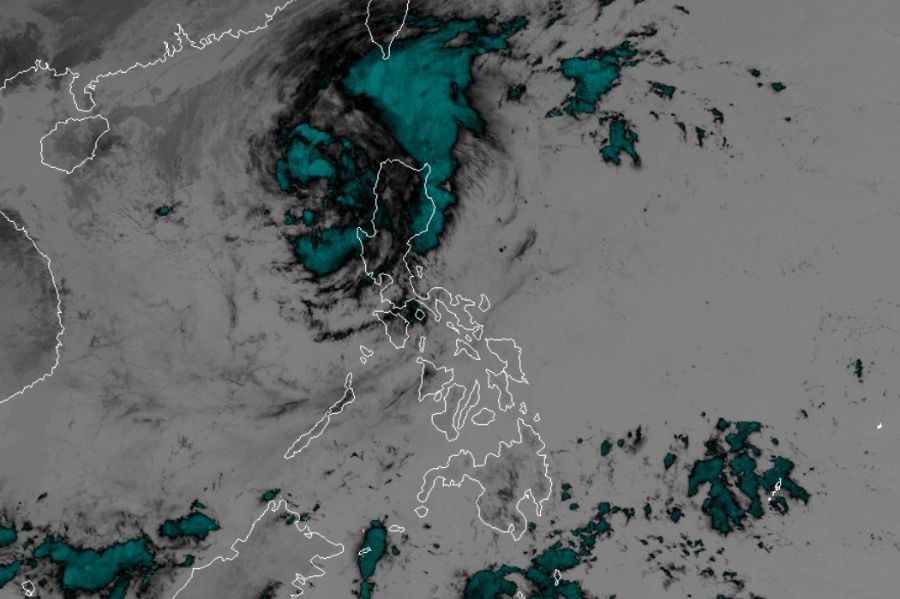
'Pepito' moves away from land, but signals remain over Luzon areas

MANILA, Philippines — Typhoon Pepito (international name Man-yi), which heavily battered parts of Central and Northern Luzon overnight, moved farther from land early Monday, November 18, for a likely exit from the Philippine area of responsibility by noon.
In its 5 a.m. bulletin, state weather bureau PAGASA located the cyclone's center 145 kilometers west of Sinait, Ilocos Sur packing maximum sustained winds of 130 kilometers per hour (kph) and gustiness of up to 160 kph. Pepito is moving northwestward at 30 kph.
Areas under cyclone warning
Despite Pepito's weakening from "super typhoon" category to still powerful typhoon-level winds as it traversed land over the weekend, PAGASA maintained cyclone warning signals over parts of Central and Northern Luzon.
Signal No. 3
Areas likelly to experience storm-force winds of 89-117 kph in 18 hours are:
- The northern and western portions of Ilocos Sur (Gregorio del Pilar, Magsingal, San Esteban, Banayoyo, Burgos, City of Candon, Santa Lucia, Santiago, San Vicente, Santa Catalina, Lidlidda, Nagbukel, Sinait, Suyo, Sigay, San Ildefonso, Galimuyod, City of Vigan, San Emilio, Cabugao, Caoayan, San Juan, Santa, Bantay, Santo Domingo, Tagudin, Santa Cruz, Santa Maria, Narvacan, Salcedo)
- The northwestern portion of La Union (Luna, Bangar, Balaoan, Bacnotan)
- The western portion of Abra (San Quintin, Langiden, Pidigan, Pilar)
Signal No. 2
Areas under this signal will likely experience gale-force winds of 62-88 kph in 24 hours.
- Ilocos Norte
- The rest of Ilocos Sur
- The rest of La Union
- Pangasinan
- The rest of Abra
- The western portion of Mountain Province (Besao, Tadian, Sagada, Bauko), Benguet
- The northern portion of Zambales (Santa Cruz, Candelaria)
Signal No. 1
The lowest cyclone warning is of strong winds of 39-61 kph in 36 hours.
- Apayao
- Kalinga
- The rest of Mountain Province
- Ifugao
- The western portion of Cagayan (Lasam, Santo Niño, Solana, Enrile, Tuao, Piat, Rizal, Allacapan, Ballesteros, Abulug, Pamplona, Claveria, Santa Praxedes, Sanchez-Mira)
- Nueva Vizcaya
- The northern and central portions of Nueva Ecija (Bongabon, San Leonardo, Cabanatuan City, Santa Rosa, Jaen, Cuyapo, Talavera, Santo Domingo, Rizal, Zaragoza, Llanera, Guimba, Aliaga, Pantabangan, Science City of Muñoz, General Mamerto Natividad, Carranglan, Quezon, San Jose City, Lupao, Nampicuan, Talugtug, Licab, San Antonio, Palayan City, Laur)
- Tarlac
- Central portion of Zambales (Botolan, Iba, Cabangan, Palauig, Masinloc)
Storm surge other warnings
PAGASA warns of moderate to high risk of storm surge in low-lying coastal areas of Ilocos Region, Isabela, and Central Luzon.
Very rough seas with waves up to 5.0 meters are expected over the seaboards of Batanes, while waves up to 4.5 meters may affect the western seaboard of Ilocos Norte and seaboards of Ilocos Sur and Isabela. All types of vessels are advised to remain in port.
Forecast track
After exiting PAR, Pepito is expected to turn more westward or west-southwestward tomorrow due to an incoming northeasterly wind surge.
The same surge will cause the typhoon to weaken further, potentially becoming a remnant low by late Wednesday or early Thursday near the coast of southern China.
- Latest
- Trending


