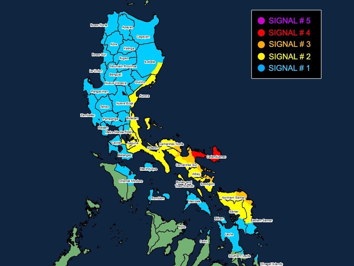
'Pepito' now a super typhoon, set to slam Bicol

MANILA, Philippines — Tropical cyclone "Pepito" (international name: Man-Yi) has intensified into a super typhoon as it barrels toward Bicol Region.
As of 10 a.m. on Saturday, November 16, PAGASA said Pepito is located 185 kilometers east of Catarman, Northern Samar, or 250 kilometers east of Juban, Sorsogon.
With peak winds of 185 kilometers per hour and gusts up to 230 kph, Pepito's central pressure stands at 925 hPa.
It is now moving west-northwestward at 25 kph.
Wind signals
The following areas are under tropical cyclone wind signals:
Signal No. 4
- Catanduanes and the northeastern portion of Camarines Sur (Garchitorena, Presentacion, Caramoan, Lagonoy, San Jose)
Signal No. 4 has been raised in areas expected to experience typhoon-force winds (118 kph or more), which could cause severe damage to buildings, power lines and infrastructure. Residents in these areas should prepare for extensive impacts and possible destruction.
Signal No. 3
Luzon
- eastern portion of Camarines Norte (Vinzons, Talisay, Mercedes, Daet, Basud, San Vicente, San Lorenzo Ruiz)
- northern and southeastern portion of Camarines Sur (Sagñay, Tigaon, Goa, Tinambac, Siruma, Buhi, Ocampo, Iriga City, Sipocot, Pili, Cabusao, Calabanga, Bombon, Magarao, Canaman, Naga City, Camaligan)
- eastern portion of Albay (City of Tabaco, Malilipot, Tiwi, Malinao, Santo Domingo, Manito, Legazpi City, Bacacay, Rapu-Rapu)
- northeastern portion of Sorsogon (Prieto Diaz, City of Sorsogon, Gubat)
Visayas
- eastern portion of Northern Samar (Palapag, Laoang, Mapanas, Gamay, Lapinig, Catubig, Pambujan)
- northern portion of Eastern Samar (San Policarpo, Arteche, Oras, Jipapad)
In areas under Wind Signal No. 3, storm-force winds of 89 to 117 kph may cause moderate to significant damage to structures, crops and vehicles, while also leading to widespread power interruptions.
Signal No. 2
Luzon
- southeastern portion of Isabela (Dinapigue)
- Aurora
- Quezon
- eastern portion of Rizal (Tanay, Pililla, Jala-Jala)
- Laguna
- rest of Camarines Norte
- rest of Camarines Sur
- rest of Albay
- rest of Sorsogon
- Burias Island
- Ticao Island
Visayas
- central portion of Eastern Samar (Dolores, Maslog, Can-Avid, Taft, Sulat, San Julian, City of Borongan)
- northern portion of Samar (Matuguinao, Calbayog City, Santa Margarita, San Jorge, San Jose de Buan, Tarangnan, Motiong, Gandara, Jiabong, City of Catbalogan, Paranas, Hinabangan, San Sebastian, Pagsanghan)
- rest of Northern Samar
Signal No. 2 indicates gale-force winds (62 to 88 kph), which may affect weaker structures and disrupt daily activities.
Signal No. 1
Luzon
- Mainland Cagayan
- rest of Isabela
- Quirino
- Nueva Vizcaya
- Apayao
- Kalinga
- Abra
- Mountain Province
- Ifugao
- Benguet
- Ilocos Norte
- Ilocos Sur
- La Union
- Pangasinan
- Nueva Ecija
- Bulacan
- Tarlac
- Pampanga
- Zambales
- Bataan
- Metro Manila
- rest of Rizal
- Cavite
- Batangas
- Marinduque
- northern portion of Oriental Mindoro (Puerto Galera, San Teodoro, Naujan, Baco, Victoria, Socorro, Pinamalayan, Bansud, Gloria, Pola, City of Calapan)
- Romblon
- rest of Masbate
Visayas
- rest of Eastern Samar
- rest of Samar
- Biliran
- northern and central portions of Leyte (Tunga, Pastrana, San Miguel, Matag-Ob, Tolosa, Palo, Calubian, Leyte, Mayorga, Julita, Carigara, Babatngon, Dagami, Jaro, San Isidro, Santa Fe, Albuera, Villaba, La Paz, Palompon, Macarthur, Tabontabon, Tanauan, Merida, Ormoc City, Isabel, Dulag, Capoocan, Alangalang, Burauen, Tabango, Tacloban City, Kananga, Barugo, Abuyog, Javier, City of Baybay, Mahaplag)
- northeastern portion of Southern Leyte (Silago)
- northernmost portion of Cebu (Daanbantayan, Medellin) including Bantayan Islands
- northernmost portion of Iloilo (Carles)
Mindanao
- northern portion of Dinagat Islands (Loreto, Tubajon)
Signal No. 1 warns of strong winds (39 to 61 kph), with minimal damage expected.
The strongest wind signal that may be issued is Signal No. 5, which would bring catastrophic winds (220 kph or more), potentially causing severe destruction.
Storm surge, sea conditions
The state weather bureau warned of a high risk of life-threatening storm surges, particularly in the Bicol Region, parts of Eastern Samar, Leyte and Northern Samar.
Coastal communities could experience storm surges exceeding 3 meters in height within the next 48 hours, with significant flooding and damage expected in these areas.
A gale warning is in effect for the eastern and southern seaboards of Southern Luzon and the Visayas.
As Typhoon Pepito intensifies, PAGASA also warned of dangerous sea conditions over the next 24 hours.
Waves as high as 14 meters are expected in the seaboard of Catanduanes, while areas like northern Camarines Sur could see waves up to 12 meters.
Other areas, including the northern and eastern seaboards of Northern Samar and Camarines Norte, will experience waves of 9 meters.
The eastern seaboards of Albay, Sorsogon and Eastern Samar will face waves of up to 7 meters, and some other parts of Bicol and Polillo Islands may see waves as high as 5.5 meters.
PAGASA urged all mariners, especially small boats, to avoid sea travel during the hazardous conditions.
Track, intensity outlook
Pepito is expected to continue moving west-northwestward, with a potential landfall near Catanduanes later Saturday or early Sunday morning. However, there is still uncertainty in its path, with possible landfall scenarios in the eastern coasts of Camarines Sur, Albay, or even Quezon and Aurora.
The super typhoon is anticipated to pass over Bicol, Quezon, Aurora, Nueva Ecija and Pangasinan before exiting the Philippine area of responsibility by Monday morning.
While Pepito is predicted to weaken as it moves inland, it is still expected to maintain typhoon strength until it reaches the West Philippine Sea.
PAGASA said Pepito could experience an eyewall replacement cycle, which may temporarily change its intensity, but it will still remain a powerful super typhoon or typhoon as it moves through the country.
- Latest
- Trending


