More areas under Wind Signals No. 1 and 2 as Typhoon Pepito gains strength
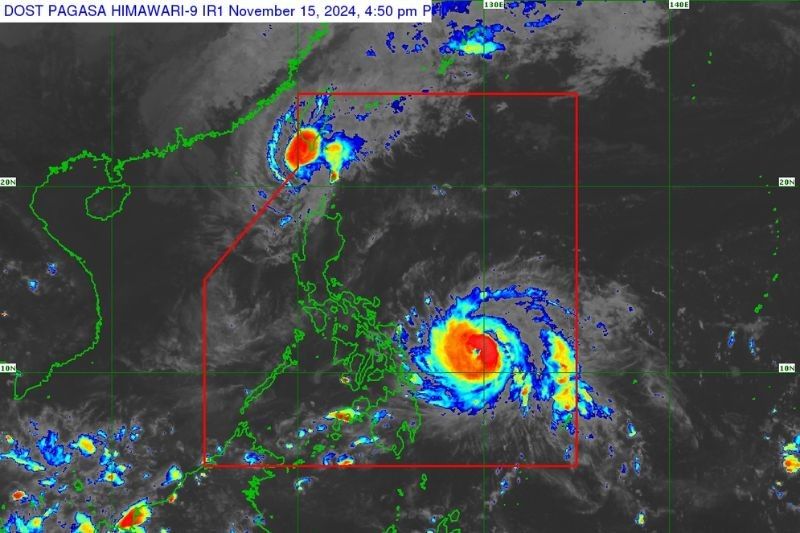
MANILA, Philippines — State weather bureau PAGASA has placed more areas under Wind Signals No. 1 and 2 as Typhoon Pepito (Man-Yi) gains strength on Friday afternoon, November 15.
As of 4 p.m., Pepito was spotted 465 kilometers east of Guian, Eastern Samar, bringing peak winds of 150 kilometers per hour (kph) with gusts reaching up to 185 kph. The typhoon was seen moving west-northwestward at 30 kph.
Meanwhile, Severe Tropical Storm Ofel (Usagi) has weakened further and exited the Philippine area of responsibility (PAR). However, PAGASA said there is a possibility it may re-enter the region.
Ofel was last located 205 kilometers west-northwest of Itbayat, Batanes, moving north-northwestward at 15 kph. The cyclone is also carrying maximum sustained winds of 100 kph and gusts of up to 125 kph.
PAGASA has not ruled out the possibility of Typhoon Pepito intensifying into a super typhoon before making landfall, which could lead to the issuance of Wind Signal No. 5.
Wind signals
PAGASA raised tropical cyclone wind signals over the following areas due to Typhoon Pepito:
Signal No. 2, gale-force winds (62 kph to 88 kph)
Visayas
- eastern portion of Northern Samar (Mapanas, Gamay, Palapag, Lapinig, Silvino Lobos, Laoang, Catubig, Las Navas, Pambujan, Mondragon, San Roque, Catarman, Lope de Vega)
- northern portion of Eastern Samar (Arteche, Oras, San Policarpo, Dolores, Jipapad, Maslog, Can-Avid)
- northeastern portion of Samar (San Jose de Buan, Matuguinao)
Signal No. 1, strong winds (39 kph to 61 kph)
Luzon
- Aurora
- Quezon
- eastern portion of Laguna (Santa Maria, Famy, Siniloan, Pangil, Mabitac, Pakil, Paete, Kalayaan, Lumban, Cavinti, Luisiana, Pagsanjan, Santa Cruz, Magdalena, Majayjay, Liliw, Nagcarlan, San Pablo City, Rizal)
- Marinduque
- Camarines Norte
- Camarines Sur
- Catanduanes
- Albay
- Sorsogon
- Masbate
Visayas
- rest of Northern Samar
- rest of Eastern Samar
- rest of Samar
- Biliran
Only Itbayat, Batanes in Northern Luzon remains under Wind Signal No. 1 due to Severe Tropical Storm Ofel.
Heavy rainfall
PAGASA forecast moderate to heavy rain (50-100 millimeters) over Sorsogon, Northern Samar and Eastern Samar from November 15 to 16. This may lead to localized flooding in urbanized, low-lying areas and near riverbanks. Landslides are also possible.
Moderate to torrential rainfall is expected to begin on Saturday afternoon, November 17, and continue into Sunday afternoon.
Areas to experience moderate to heavy rain (50-100 mm):
- Samar
- Biliran
- Leyte
- Romblon
- Marinduque
- Pampanga
- Bulacan
- Bataan
- Metro Manila
- Rizal
- Cavite
- Laguna
- Batangas
Areas to experience heavy to intense rain (100-200 mm):
- Quezon
- Aurora
- Masbate
- Northern Samar
- Eastern Samar
With this amount of rainfall, several flooding events are expected to occur, while landslides are also possible in moderate to highly susceptible areas.
Areas to experience intense to torrential rain (>200 mm):
- Sorsogon
- Albay
- Camarines Sur
- Camarines Norte
- Catanduanes
Storm Surge, sea conditions
PAGASA has warned of life-threatening storm surges up to 3.0 meters in southeastern Quezon, Camarines Sur, Catanduanes, Albay, Sorsogon, northern Masbate (including Burias and Ticao Islands), Northern Samar, Eastern Samar, Samar and northern Biliran.
Rough to very rough seas with waves reaching 8.0 meters at most are also expected in these areas.
Forecast track
Typhoon Pepito is projected to make landfall in Catanduanes on Saturday morning, November 16, as it continues to move west-northwestward.
However, there's a possibility it may also make landfall over the eastern coasts of Camarines Sur, Albay, Sorsogon, Northern Samar, Quezon, or Aurora in the coming days.
PAGASA advised that areas not directly hit by Typhoon Pepito should still exercise caution, as they may experience heavy rainfall, strong winds and potential storm surges.
Pepito will continue to intensify on Friday and Saturday before making landfall, the state weather bureau said.
The typhoon is expected to weaken into a severe tropical storm once it is over the West Philippine Sea on November 18.
- Latest
- Trending


