


Metro Manila, others still under Signal No. 2 as 'Kristine' gains speed over Northern Luzon waters
MANILA, Philippines — Metro Manila and other areas in Luzon remain under Signal No. 2 as Severe Tropical Storm Kristine (international name: Trami) maintains its strength while accelerating west-northwestward over the sea west of Northern Luzon.
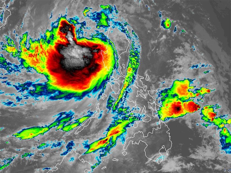
As of 4 a.m. on Friday, October 25, PAGASA reported that Kristine was spotted 125 kilometers west-northwest of Bacnotan, La Union.
Kristine is carrying maximum sustained winds of 95 kilometers per hour, with gusts reaching up to 115 kph. Its central pressure stands at 985 hPa.
It is now moving west northwestward at 25 kph.
Wind Signals
The following areas are under tropical cyclone wind signals:
Signal No. 2
- Cagayan including Babuyan Islands
- Isabela
- Quirino
- Nueva Vizcaya
- Apayao
- Kalinga
- Abra
- Ifugao
- Mountain Province
- Benguet
- Ilocos Norte
- Ilocos Sur
- La Union
- Pangasinan
- Aurora
- Nueva Ecija
- Tarlac
- Zambales
- Bataan
- Pampanga
- Bulacan
- Metro Manila
- northern portion of Cavite (Ternate, Maragondon, Naic, Tanza, City of General Trias, Rosario, Cavite City, Noveleta, Kawit, Imus City, Bacoor City)
- northern portion of Rizal (Cainta, Taytay, Angono, San Mateo, Rodriguez, Tanay, City of Antipolo, Baras, Teresa, Morong)
- northern portion of mainland Quezon (General Nakar)
Residents of areas under Signal No. 2 could experience minor to moderate impacts from strong winds, with winds between 62 kph and 88 kph expected within at least 24 hours.
Signal No. 1
Luzon
- Batanes
- rest of Rizal
- rest of Cavite
- Batangas
- Laguna
- rest of Quezon including Polillo Islands
- Occidental Mindoro including Lubang Islands
- Oriental Mindoro
- Marinduque
- Romblon
- northern portion of mainland Palawan (El Nido, Taytay, Araceli, Dumaran, San Vicente) including Calamian
- Cuyo
- Kalayaan Islands
- Camarines Norte
- Camarines Sur
- Catanduanes
- Albay
- northern and central portions of Sorsogon (Castilla, Magallanes, Pilar, Casiguran, Donsol, Juban, Gubat, City of Sorsogon, Prieto Diaz, Bulan)
- northern and central portions of Masbate (City of Masbate, Uson, Dimasalang, Mobo, Cawayan, Aroroy, Balud, Mandaon, Milagros, Baleno) including Ticao and Burias Islands
Visayas
- Aklan
- Capiz
- Antique including Caluya Islands
- Iloilo
- Bantayan Islands
- western portion of Northern Samar (Rosario, Biri, San Isidro, Capul, San Vicente, Victoria, Lavezares, San Antonio, San Jose, Allen, Bobon)
- northern portion of Samar (Tagapul-An)
Strong winds ranging from 39 to 61 kph may be expected in at least 36 hours or intermittent rains may be expected within 36 hours.
Heavy rains, severe winds
PAGASA said that Kristine is expected to bring heavy rains to parts of Northern and Central Luzon on Friday.
Moderate to heavy rainfall (50-100 mm) will affect several areas, including Pangasinan, La Union, Benguet, Tarlac, Pampanga, Zambales and Bataan. While torrential rains are not expected, PAGASA warned of possible flooding and landslides.
The following areas will be under threat of strong to gale-force gusts:
- Friday, October 25: MIMAROPA, Bicol Region, Visayas, Dinagat Islands, Surigao del Norte, Northern Mindanao, Zamboanga Peninsula, BARMM, SOCCSKSARGEN, and Davao Region.
- Saturday, October 26: Palawan, Siquijor, Bohol, Southern Leyte, Zamboanga del Norte, Camiguin, Dinagat Islands and Surigao del Norte.
- Sunday, October 27: Palawan, Romblon, Visayas, Siquijor, Bohol, Southern Leyte, Zamboanga del Norte, Camiguin, Dinagat Islands and Surigao del Norte.
Storm surge, sea conditions
The state weather agency warned of a minimal to moderate risk of storm surge, with heights expected to reach 1.0 to 2.0 meters above normal tide levels in the next 48 hours. Coastal areas of Ilocos Sur, La Union, Pangasinan and Zambales are especially at risk.
PAGASA also advised mariners of hazardous sea conditions and risky travel for small vessels, including motorbancas in the following areas:
- Up to 4 meters: Western seaboards of northern Palawan, including Kalayaan Islands
- Up to 3.5 meters: Remaining western seaboards of Palawan, western seaboard of Antique, western and southern seaboards of Negros Occidental and Negros Oriental, remaining seaboard of Aurora, and seaboards of northern Quezon, including Polillo Islands
- Up to 3 meters: Remaining seaboards of Luzon and Visayas
Forecast track
Kristine is expected to move further west-northwest and exit the Philippine area of responsibility (PAR) later today.
However, PAGASA said that there is a possibility that Kristine could re-enter PAR next week, depending on the development of another weather system.
While Kristine is expected to remain a severe tropical storm, there is a slight chance it could intensify into a typhoon as it moves over the West Philippine Sea in the next few days.
Meanwhile, the tropical depression seen behind Kristine is still outside PAR.
PAGASA is also monitoring a low pressure area, which may not develop into a tropical depression within the next 24 hours.


- Latest
- Trending


