Rain batters Metro Manila due to ‘Kristine’, Signal No. 3 stays up in Northern Luzon
MANILA, Philippines — A heavy rainfall warning was issued for Metro Manila and other Luzon areas on Thursday, October 24, as Severe Tropical Storm "Kristine" began to exit the country’s landmass.
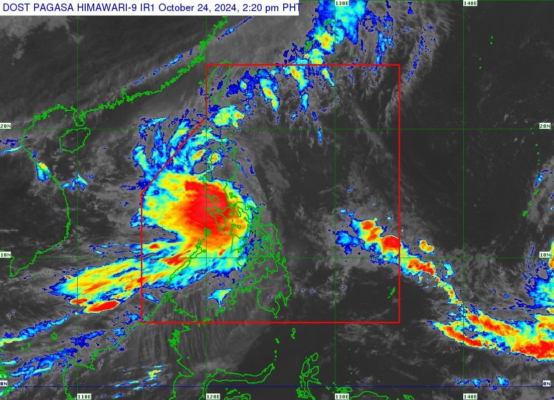
PAGASA's 2 p.m. cyclone bulletin puts Kristine over the coastal waters of Santa Cruz, Ilocos Sur. It currently packs maximum sustained winds of 95 kilometer per hour and gustiness of up to 145 kph.
The state weather bureau has put up the following Heavy Rainfall warnings as of 2 p.m.:
- Red
- Batangas
- Cavite
- Orange
- Zambales
- Bataan
- Metro Manila
- Laguna (Alaminos, Bay, Cabuyao, Calauan, Calamba, Santa Rosa, Liliw, Los Banos, Luisiana, Magdalena, Majayjay, Nagcarlan, Pagsanjan, Pila, Rizal, San Pablo, Santa Cruz, Victoria, Binan, San Pedro, Cavinti, Lumban, Kalayaan, Paete, Mabitac, Pakil, Pangil, Siniloan, Famy)
- Quezon (Tiaong, San Antonio, Candelaria, Sariaya, Dolores, Lucena, Tayabas, Lucban, Sampaloc, Pagbilao, Padre Burgos)
- Pampanga (Lubao, Sasmuan, Macabebe, Masantol, Floridablanca)
- Bulacan (Hagonoy, Paombong, Malolos, Bulakan, Meycauayan, Obando, Marilao, Bocaue, Balagtas, Guiguinto)
- Rizal (Cainta, Taytay, Angono, Binangonan, Cardona, Pililla, Jala-Jala, Baras, Morong, Teresa, Antipolo, San Mateo)
- Yellow
- Tarlac
- Rizal (Rodriguez, Tanay)
- Quezon (General Nakar, Infanta, Mauban, Real, Agdangan, Alabat, Atimonan, Buenavista, Burdeos, Calauag, Catanauan, General Luna, Guinayangan, Gumaca, Jomalig, Lopez, Macalelon, Mulanay, Panukulan, Patnanungan, Perez, Pitogo, Plaridel, Polillo, Quezon, San Andres, San Francisco, San Narciso, Tagkawayan, Unisan)
- Bulacan (Angat, Baliuag, Bustos, Calumpit, San Jose del Monte, Dona Remedios Trinidad, Norzagaray, Pandi, Plaridel, Pulilan, San Ildefonso, San Miguel, San Rafael, Santa Maria)
- Pampanga (Apalit, Arayat, Bacolor, Candaba, San Fernando, Magalang, Mexico, Minalin, San Luis, San Simon, Santa Ana, Santo Tomas, Angeles, Mabalacat, Guagua, Porac, Santa Rita)
- Laguna (Santa Maria)
In a separate advisory, PAGASA also updated its Tropical Cyclone Wind Signal warnings. While Pagasa has brought down the TCWS level of some areas, four provinces remain under Signal No. 3.
- TCWS No. 3
- Benguet
- Ilocos Sur
- La Union
- Pangasinan
- TCWS No. 2
- Luzon: Ilocos Norte, Batanes, Cagayan including Babuyan Islands, Isabela, Quirino, Nueva Vizcaya, Apayao, Kalinga, Abra, Ifugao, Mountain Province, Aurora, Nueva Ecija, Tarlac, Zambales, Bataan, Pampanga, Bulacan, Metro Manila, Rizal, Cavite, the western portion of Batangas (Nasugbu, Lian), the northern portion of Quezon (General Nakar, Infanta) including Polillo Islands, and Lubang Islands
- TCWS No. 3
- Luzon: Laguna, the rest of Batangas, rest of Quezon, the rest of Occidental Mindoro, Oriental Mindoro, Marinduque, Romblon, the northern portion of mainland Palawan (El Nido, Taytay, Araceli, San Vicente, Dumaran, Roxas) including Calamian Islands, Cuyo, and, Kalayaan Islands, Camarines Norte, Camarines Sur, Catanduanes, Albay, Sorsogon, and Masbate including Ticao and Burias Islands
- Visayas: Aklan, Capiz, Antique including Caluya Islands, Iloilo, Bantayan Islands, Northern Samar, the northern portion of Samar (Santa Margarita, Almagro, Tagapul-An, Calbayog City, Santo Nino, Gandara, Matuguinao)
PAGASA has also issued a gale warning over Luzon seaboards, as well as the western and central seaboards of Visayas.
There is a chance that after Kristine exits the Philippine area of responsibility (PAR) on Friday, it may loop back into the West Philippine Sea.
“However, this scenario heavily depends on the behavior of the weather disturbance east of the PAR region which is expected to develop into a tropical depression within the next 24 hours,” PAGASA said.


- Latest
- Trending