Signal No. 3 still up in northern Luzon as 'Kristine' slows down
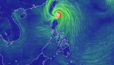
MANILA, Philippines — Signal No. 3 remains hoisted in several areas across northern Luzon as Severe Tropical Storm Kristine (international name: Trami) gradually decelerates while moving northwestward.
PAGASA reported that Kristine made landfall over Divilacan, Isabela at 12:30 a.m. on Thursday, October 24.
As of 4 a.m., Kristine was spotted in the vicinity of Tumauini, Isabela, packing maximum sustained winds of 95 kilometers per hour and gustiness of up to 160 kph.
Moving at 15 kph, Kristine continues its track over northern Luzon and is expected to exit the Philippine area of responsibility (PAR) by Friday afternoon.
Wind signals
The following areas are under tropical cyclone wind signals:
Signal No. 3
- southern portion of Cagayan (Peñablanca, Tuguegarao City, Enrile, Solana, Iguig, Tuao)
- Isabela
- Quirino
- Nueva Vizcaya
- Kalinga
- Mountain Province
- Ifugao
- southern portion of Abra (Malibcong, Licuan-Baay, Sallapadan, Daguioman, Bucloc, Boliney, Tubo, Luba, Manabo, Bucay, Villaviciosa, Pilar, San Isidro, Peñarrubia)
- Benguet
- northern and central portions of Aurora (Dilasag, Casiguran, Dinalungan, Dipaculao, Maria Aurora, Baler)
- northern portion of Nueva Ecija (Carranglan, Lupao, San Jose City, Pantabangan, Guimba, Santo Domingo, Talavera, Llanera, Rizal, Bongabon, Talugtug, Science City of Muñoz, Cuyapo, Nampicuan)
- northern portion of Tarlac (Mayantoc, San Clemente, Camiling, Santa Ignacia, Gerona, Paniqui, Moncada, San Manuel, Anao, Ramos, Pura, Victoria)
- northern portion of Zambales (Candelaria, Santa Cruz, Masinloc)
- Pangasinan
- La Union
- central and southern portions of Ilocos Sur (Cervantes, Quirino, Sigay, Suyo, Alilem, Sugpon, Tagudin, Santa Cruz, Salcedo, Gregorio del Pilar, San Emilio, Lidlidda, Burgos, San Esteban, Santiago, Banayoyo, Galimuyod, City of Candon, Santa Lucia, Nagbukel, Santa Maria, Narvacan)
Winds between 89 kph to 117 kph may be expected in at least 18 hours. Residents of areas under Signal No. 3 could experience moderate to significant impacts from strong winds.
Signal No. 2
- Ilocos Norte
- rest of Ilocos Sur, Apayao
- rest of Abra
- rest of Cagayan including Babuyan Islands
- rest of Aurora
- rest of Nueva Ecija
- Bulacan
- rest of Tarlac
- Pampanga
- rest of Zambales
- Bataan
- Metro Manila
- Cavite
- Laguna
- Rizal
- Batangas
- northern and central portions of Quezon (Lucena City, Pagbilao, Infanta, Tiaong, San Antonio, Candelaria, Lucban, Sampaloc, Sariaya, City of Tayabas, Mauban, Dolores, General Nakar, Real) including Polillo Islands, and Lubang Island
Residents of areas under Signal No. 2 could experience minor to moderate impacts from strong winds, with winds between 62 kph and 88 kph expected within at least 24 hours.
Signal No. 1
Luzon
- Batanes
- rest of Quezon
- rest of Occidental Mindoro
- Oriental Mindoro
- Marinduque
- Romblon
- northern portion of mainland Palawan (El Nido, Taytay, Araceli, San Vicente, Dumaran, Roxas) including Calamian Islands and Cuyo Islands
- Camarines Norte
- Camarines Sur
- Catanduanes
- Albay
- Sorsogon
- Masbate including Ticao and Burias Islands
Visayas
- Aklan
- Capiz
- Antique including Caluya Islands
- Iloilo
- Guimaras
- northern portion of Negros Occidental (Pulupandan, Bacolod City, Silay City, City of Talisay, Enrique B. Magalona, Manapla, City of Victorias, Cadiz City, Sagay City, City of Escalante, Toboso, Valladolid, Bago City, Murcia, Salvador Benedicto, Calatrava)
- northern portion of Cebu (Medellin, Daanbantayan, San Remigio, City of Bogo, Tabuelan, Tabogon) including Bantayan Islands
- Northern Samar
- Samar
- Biliran
- northern portion of Eastern Samar (Oras, Can-Avid, Maslog, San Policarpo, Taft, Dolores, Jipapad, Arteche, Sulat)
- northern portion of Leyte (San Isidro, Calubian, San Miguel, Babatngon, Barugo, Tunga, Carigara, Capoocan, Leyte, Villaba, Tabango)
Residents of areas under Signal No. 1 could experience minimal to minor impacts from strong winds, ranging from 39 to 61 kph.
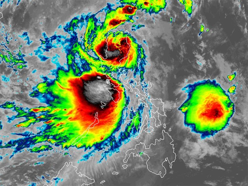
Severe winds
Strong to gale-force gusts are forecasted due to the storm's circulation and the influence of northeasterly windflow over the following areas:
- Thursday, October 24: MIMAROPA, Bicol Region, Visayas, Basilan, Sulu, Tawi-Tawi, Zamboanga del Norte, Lanao del Sur, Northern Mindanao, Dinagat Islands, Surigao del Norte, Davao del Sur and Davao Oriental.
- Friday, October 25: MIMAROPA, Bicol Region, Western Visayas, Negros Occidental, Siquijor, Bohol, Southern Leyte, Zamboanga del Norte, Basilan, Sulu, Tawi-Tawi, Camiguin and Dinagat Islands
- Saturday, October 26: MIMAROPA, Bicol Region, Western Visayas, Negros Occidental, Siquijor, Zamboanga del Norte, Camiguin, Dinagat Islands, Siargao, and Bucas Grande Island Group
Storm surge, sea conditions
PAGASA said that several areas including Ilocos Norte, Ilocos Sur, La Union, Pangasinan, Cagayan, Isabela, Aurora, Zambales and Quezon could experience storm surges reaching up to 3.0 meters above normal tide levels.
It also warned mariners of hazardous sea conditions and risky travel for small vessels, including motorbancas in the following areas:
- Up to 8.0 meters: Cagayan Valley, Ilocos Region and Zambales
- Up to 7.0 meters: Bataan
- Up to 6.0 meters: Batangas and Lubang Island
- Up to 5.5 meters: Occidental Mindoro and Calamian Islands
- Up to 4.5 meters: Aurora, northern and eastern Catanduanes, northern Camarines Sur, and western Western Visayas, Negros Occidental and Palawan
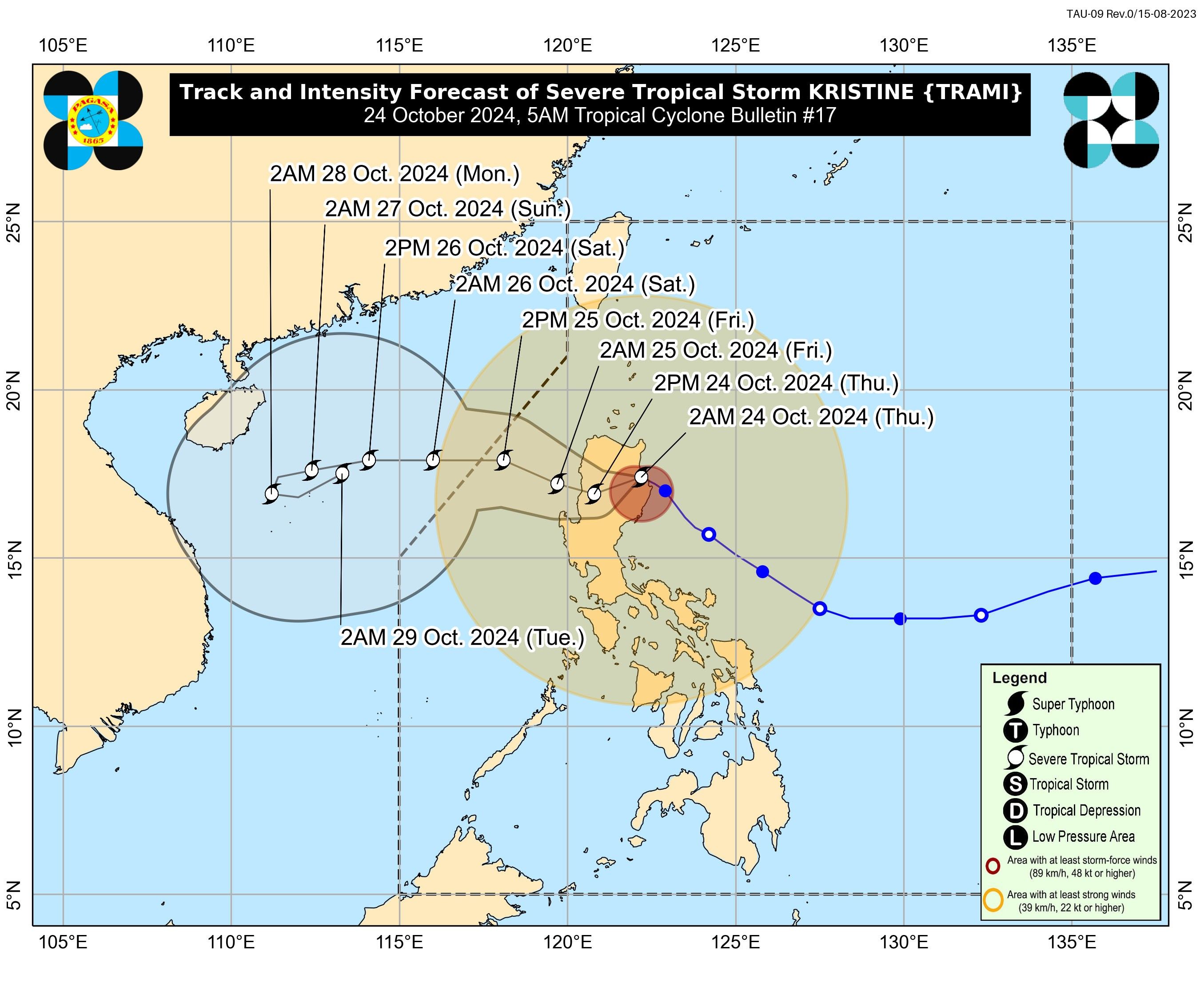
Track, intensity outlook
Kristine is expected to cross northern Luzon on Thursday, weakening slightly due to land interaction.
However, PAGASA said that it may regain strength once it moves over the West Philippine Sea.
Kristine is expected to exit PAR by Friday afternoon.


- Latest
- Trending