Kristine enters PAR, may become typhoon
MANILA, Philippines — Tropical Depression Kristine entered the Philippine area of responsibility (PAR) and is expected to intensify into a typhoon and make landfall in Northern Luzon by Thursday evening or Friday morning, the Philippine Atmospheric, Geophysical and Astronomical Services Administration (PAGASA) said yesterday.
“Sunday night, the low-pressure area (LPA) that we are monitoring developed into a tropical depression. It entered PAR (Monday) midnight,” PAGASA administrator Nathaniel Servando said during a press conference.
PAGASA weather specialist Veronica Torres said Kristine is still far from the Philippine landmass but is already affecting almost all areas in the country.
“Its circulation is elongated, that’s why Tropical Depression Kristine is already affecting the eastern portion of Southern Luzon and the Visayas. Its trough or extension is currently affecting almost the entire country,” Torres said.
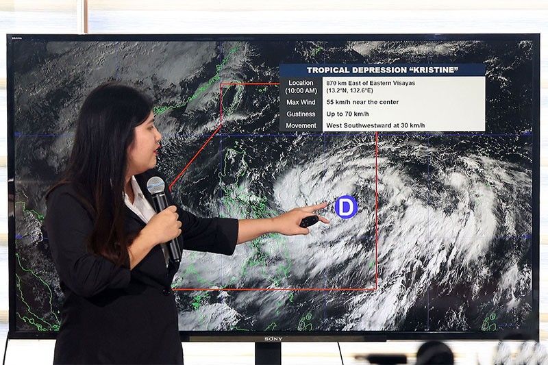
As of 5 p.m. yesterday, the center of Kristine was located at 760 kilometers east of Catarman, Northern Samar, with maximum sustained winds of 55 km per hour near the center and gustiness of up to 70 kph as it slightly decelerates while moving westward over the Philippine Sea at 15 kph.
Torres said Kristine, after 24 hours, is expected to be located at 490 km east of Virac, Catanduanes and may intensify into a tropical storm.
After 48 hours, Kristine may further intensify into a severe tropical storm and will be located 520 km east of Baler in Aurora, she added.
“After 72 hours, Kristine will approach the landmass, mostly Northern Luzon area with location of 520 km east of Baler, Aurora and it will intensify into a severe tropical storm category at 15 kph movement,” Torres also said, noting that Kristine is expected to make landfall in Northern Luzon.
She added that there is a probability that Kristine will also make landfall in Central Luzon.
According to Torres, Tropical Depression Kristine may further intensify after it makes landfall in Northern Luzon on Thursday evening or Friday morning.
Juanito Galang, PAGASA in-charge deputy administrator for operations and services, said the weather bureau does not discount the possibility that Kristine will reach super typhoon category. Under PAGASA’s tropical cyclone wind signal system, a super typhoon is declared if it has sustained winds of 185 kph.
As of 5 p.m., tropical cyclone wind signal No. 1 was hoisted in the southeastern portion of Isabela (including Palanan and Dinapigue), Aurora, northern and eastern portions of Quezon (particularly Tagkawayan, Guinayangan, Buenavista, San Narciso, San Andres, General Nakar, Pitogo, San Francisco, Calauag, Pagbilao, Infanta, Lopez, Catanauan, Mulanay, Unisan, General Luna, Plaridel, Quezon, Alabat, Sampaloc, Padre Burgos, Macalelon, Mauban, Perez, Agdangan, Gumaca, Atimonan and Real), Polillo Islands, Camarines Norte, Camarines Sur, Catanduanes, Albay, Sorsogon and Masbate, including Ticao Island and Burias Island.
In the Visayas, tropical cyclone wind signal No. 1 was raised in Eastern Samar, Northern Samar, Samar, Leyte, Biliran and Southern Leyte and in Mindanao, tropical cyclone wind signal No. 1 was raised in Dinagat Islands and Surigao del Norte including the Siargao-Bucas Grande Group.
PAGASA said the highest wind signal which may be hoisted during the occurrence of Tropical Depression Kristine is wind signal No. 4.
Torres said heavy to intense rains were experienced yesterday in Catanduanes, Camarines Norte, Camarines Sur and Northern Samar while moderate to heavy rains were experienced in Quezon and the rest of Bicol region and Eastern Visayas.
Yesterday, the Regional Disaster Risk Reduction and Management Council in Bicol placed its emergency operations center on red alert to immediately respond to calls for help. The RDRRMC asked residents to check the integrity of their houses, repair weak parts and prepare their “go bag” containing items needed for survival.
The Philippine Coast Guard (PCG) stations in Camarines Norte, Catanduanes and Surigao del Norte ordered the suspension of sea travel as a precaution.
In Southern Tagalog, PCG commander Commodore Geronimo Tuvilla also imposed a “no sail policy” and placed the entire district under heightened alert.
“In preparation, all units, including deployable response groups and floating assets, are on heightened alert. Logistical arrangements are being finalized to ensure readiness for emergency response operations throughout the district’s area of responsibility,” a post on Facebook reads.
Tuvilla said all water assets in Southern Tagalog are ready to conduct search and rescue missions when needed, as he urged shipping and fishing companies as well as fishermen and small boat operators to secure their vessels in shelter areas and to refrain from venturing out to sea.
Philippine Ports Authority general manager Jay Santiago directed all port management offices (PMO) to make preparations for the impact of Kristine and, this early, for the influx of passengers during the observance of All Saints’ Day on Nov. 1 and All Souls’ Day on Nov. 2.
As of yesterday noon, 566 passengers were stranded in Bicol ports.
“The safety and convenience of our personnel and passengers during these critical periods are our utmost priorities. Emergency response teams of each PMO should be activated and safety protocols must be reinforced to protect both personnel and port users,” Santiago said.
Also preparing for impact is the Philippine National Police (PNP), which activated its emergency response teams to assist communities.
Brig. Gen. Jean Fajardo, PNP public information officer, said their national task force on disaster was alerted over the weekend ahead of the storm’s entry into the country’s area of responsibility.
“Search and rescue teams were activated, in case there is a need to deploy them,” she said in a press briefing at Camp Crame.
Interior Secretary Jonvic Remulla directed local government units to conduct preemptive or mandatory evacuation, saying the LGUs should be able to identify areas with high to very high susceptibility to storm surges, floods and landslides. — Evelyn Macairan, Helen Flores, Emmanuel Tupas


- Latest
- Trending