‘Julian’ almost a super typhoon
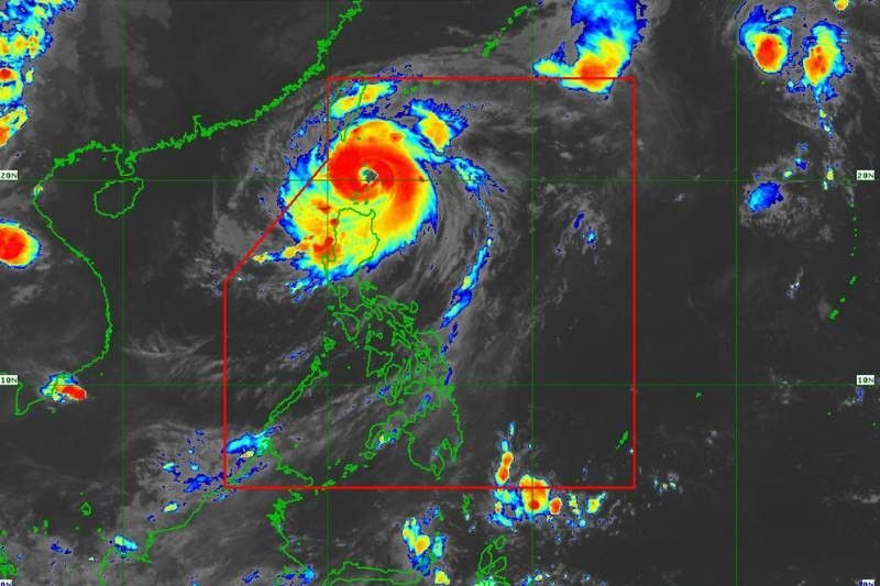
MANILA, Philippines — Typhoon Julian (international name: Krathon) has further intensified, nearing the super typhoon category as it barrels across the northernmost islands of Luzon, state weather bureau PAGASA said.
As of 7 a.m. on Monday, September 30, the eye of Julian was located over the coastal waters of Balintang Island, Calayan, Cagayan, with maximum sustained winds of 175 kilometers per hour (kph) near the center, gustiness reaching up to 215 kph and a central pressure of 940 hPa.
The storm is moving west-northwestward at 10 kph, and its powerful winds extend as far as 560 kilometers from the center.
Areas under wind signal
Tropical Cyclone Wind Signal (TWCS) No. 4 is raised over Batanes and the northern portion of the Babuyan Islands, including Calayan, warning of typhoon-force winds ranging from 118 to 184 kph.
These areas can expect significant to severe threats to life and property within the next 12 hours.
TCWS No. 3 is in effect for the rest of the Babuyan Islands and the northeastern portion of mainland Cagayan, where winds of 89 to 117 kph may cause moderate to significant impacts.
TCWS No. 2 covers areas of northern Luzon:
- The rest of mainland Cagayan
- Apayao
- Northern portion of Abra (Tineg, Lacub, Malibcong, Licuan-Baay, San Juan, Lagayan, Lagangilang, Dolores, Daguioman, Danglas, La Paz)
- Northern portion of Kalinga (Pinukpuk, Balbalan, City of Tabuk, Rizal)
- Ilocos Norte
- Northern portion of Ilocos Sur (Sinait, Cabugao)
TCWS No. 1 stretches to the Ilocos Region, which includes:
- The rest of Ilocos Sur
- La Union
- Pangasinan
- The rest of Abra
- The rest of Kalinga
- Ifugao
- Mountain Province
- Benguet
- Isabela
- Nueva Vizcaya
- Quirino
- Aurora
- Northern and eastern portions of Nueva Ecija (Cuyapo, Rizal, Laur, Pantabangan, Science City of Muñoz, Gabaldon, Carranglan, San Jose City, Lupao, Talugtug, Bongabon, Llanera, Talavera, Palayan City, General Mamerto Natividad)
- Polillo Islands
Heavy rainfall and severe winds
Residents in areas under wind signal no. 4 are urged to prepare for the brunt of the typhoon-force winds this morning and into the afternoon, with the possibility of wind Signal No. 5 being raised as Julian intensifies.
Moderate to significant damage is anticipated in areas under TCWS Nos. 3 and 2, while localized gusts may affect regions as far as Metro Manila, Calabarzon and parts of Central Luzon due to the typhoon’s expansive wind field.
PAGASA warns of strong to gale-force winds along the coasts, particularly in upland and exposed areas, with widespread power outages, property damage and fallen trees expected.
Forecast track
Typhoon Julian is projected to pass close to Balintang Island and Batanes on Monday, with a possible landfall.
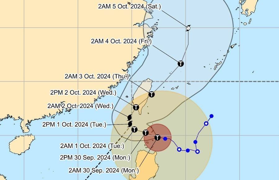
By Tuesday, it is expected to move northeastward toward Taiwan. Julian may briefly exit the Philippine area of responsibility (PAR) during this period but will continue to affect northern Luzon with powerful winds and rains.
As it approaches Taiwan’s rugged terrain by Wednesday, it is anticipated to weaken, though it may still pose significant threats before exiting PAR by Thursday.


- Latest
- Trending