Northern Luzon still under Signal No. 2 as 'Enteng' crosses West Philippine Sea
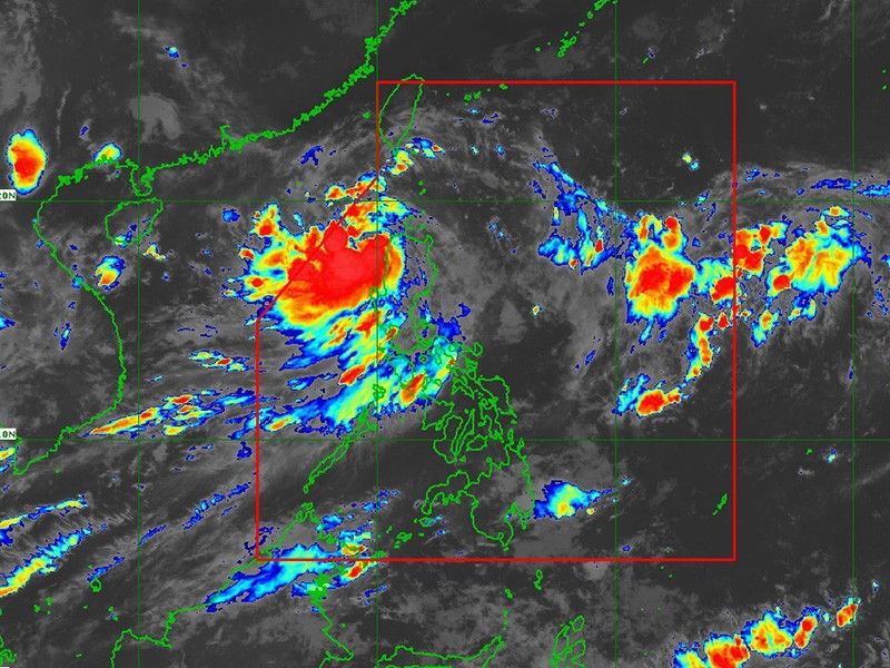
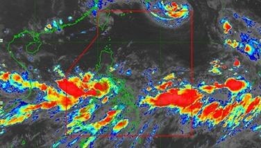
MANILA, Philippines — Several areas in Northern Luzon stayed under Signal No. 2 on Tuesday morning, September 3, as Tropical Storm Enteng advanced west-northwest over the West Philippine Sea.
As of 7 a.m., state weather bureau PAGASA reported that Enteng was seen over the coastal waters of Laoag City, Ilocos Norte.
Moving at a speed of 20 kilometers per hour, the tropical storm was carrying peak winds of 75 kph near its center, with gusts reaching up to 115 kph.
Wind Signals
Tropical cyclone wind signals are raised over the following areas:
Signal No. 2
- Ilocos Norte
- northern portion of Ilocos Sur (Sinait, Cabugao, San Juan, Magsingal, Santo Domingo, San Ildefonso, San Vicente, Santa Catalina, City of Vigan, Bantay, Santa, Caoayan)
- Apayao
- Abra
- northern and western portions of Kalinga (Balbalan, Pinukpuk, Lubuagan, Pasil)
- western portion of Mainland Cagayan (Piat, Santo Nino, Camalaniugan, Tuao, Pamplona, Rizal, Claveria, Lasam, Aparri, Ballesteros, Abulug, Allacapan, Sanchez-Mira, Santa Praxedes) including Babuyan Islands (Dalupiri Is. and Fuga Is.)
Residents of areas under Signal No. 1 should anticipate wind speeds between 39 and 61 kph, posing a minor to moderate threat to life and property.
Signal No. 1
- rest of Ilocos Sur
- northern portion of La Union (Luna, Santol, San Juan, Bagulin, Bangar, San Gabriel, Bacnotan, Sudipen, Balaoan, City of San Fernando)
- rest of Kalinga, Mountain Province, Ifugao, the northern portion of Benguet (Mankayan, Kapangan, Atok, Kabayan, Kibungan, Bakun, Buguias)
- Batanes
- rest of Mainland Cagayan, the rest of Babuyan Islands, the northern and western portions of Isabela (Divilacan, Santo Tomas, Alicia, San Mateo, Aurora, Santa Maria, Quezon, Ramon, Naguilian, Roxas, Luna, Delfin Albano, City of Cauayan, San Pablo, Ilagan City, Angadanan, Benito Soliven, City of Santiago, Tumauini, Cabagan, Reina Mercedes, San Manuel, Cabatuan, Quirino, Gamu, San Isidro, Mallig, Cordon, Maconacon, Burgos)
- northern portion of Nueva Vizcaya (Ambaguio, Bagabag, Villaverde, Diadi, Solano)
Residents of areas under Signal No. 1 could experience minimal to minor impacts from strong winds, ranging from 39 to 61 kph.
Heavy rainfall
Tropical Storm Enteng is expected to bring significant rainfall across the following regions:
Tuesday, September 3
- 100-200 mm: Ilocos Region
- 50-100 mm: Cagayan Valley and the Cordillera Administrative Region
Wednesday, September 4
- 50-100 mm: Ilocos Norte
Th rainfall could lead to flooding and landslides, particularly in elevated and previously rain-affected areas.
The enhanced southwest monsoon will further contribute to heavy rainfall in various parts of Luzon over the next few days.
Forecast track
Enteng is expected to continue moving west-northwestward over the next 24 hours and is projected to turn westward towards Hainan, China, by Saturday, September 7.
PAGASA said Enteng is likely to reach severe tropical storm status on Wednesday and may become a typhoon by Thursday, September 5.


- Latest
- Trending