Signal No. 1 hoisted over parts of Luzon, Visayas due to 'Enteng'
MANILA, Philippines — State weather bureau PAGASA raised Signal No. 1 in several areas in Luzon and Visayas due to Tropical Depression Enteng.
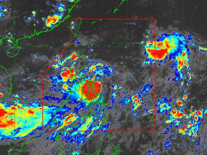
In its advisory on Sunday afternoon, September 1, Enteng was spotted 100 kilometers northeast of Catarman, northern Samar or 115 km east southeast of Virac, Catanduanes.
Moving northwestward at 15 kilometers per hour, Enteng was packing peak winds of 55 kilometers an hour and gusts of up to 70 kph.
The following areas are under Tropical Cyclone Wind Signal No. 1:
Luzon
- southeastern portion of Cagayan (Baggao, Peñablanca)
- eastern portion of Isabela (Palanan, Dinapigue, Divilacan, San Agustin, San Guillermo, Jones, Echague, San Mariano, Maconacon, San Pablo, Cabagan, Tumauini, Ilagan City)
- southern portion of Quirino (Nagtipunan, Maddela)
- northern portion of Aurora (Dilasag, Casiguran, Dinalungan, Dipaculao, Baler)
- Polillo Islands
- southern portion of mainland Quezon (Tagkawayan, Guinayangan, Buenavista, San Narciso, Mulanay, San Andres, San Francisco, Lopez, Calauag, Catanauan, Gumaca, Macalelon, General Luna, Quezon, Alabat, Perez)
- Camarines Norte
- Camarines Sur
- Catanduanes
- Albay
- Sorsogon
- Masbate incuding Ticao and Burias Islands
Visayas
- Northern Samar
- Samar
- Eastern Samar
- Biliran
- northeastern portion of Leyte (Babatngon, San Miguel, Tacloban City, Alangalang, Santa Fe, Palo, Barugo)
Rainfall outlook
Below are PAGASA's current forecast accumulated rainfall in several regions due to Tropical Depression Enteng:
Sunday to Monday afternoon
- 100-200 mm: Polillo Islands, Catanduanes, Camarines Norte, Camarines Sur, Masbate, Albay, Sorsogon, Northern Samar and Samar
- 50-100 mm: Metro Manila, the rest of CALABARZON, Marinduque, Romblon, Eastern Samar, Biliran and the northern portion of Leyte.
Monday afternoon to Tuesday afternoon
- 100-200 mm: Isabela, Cagayan, Abra, Ilocos Norte
- 50-100 mm: Aurora and the rest of Ilocos Region, Cordillera Administrative Region, and mainland Cagayan Valley
Tuesday afternoon to Wednesday afternoon
- 100-200 mm: Babuyan Islands, Apayao, Ilocos Norte, and the northern portion of Ilocos Sur
- 50-100 mm: Batanes, mainland Cagayan, and the rest of Cordillera Administrative Region and Ilocos Region.
PAGASA warned that areas with elevated or mountainous terrain may experience higher rainfall, leading to an increased risk of flooding and landslides, especially in locations that have already seen significant rainfall in recent days.
Track, intensity outlook
Enteng is projected to move northwestward on Sunday before turning northward on Monday, with potential landfall over the Bicol Region-Eastern Visayas area within the next 48 hours, according to the state weather bureau.
The tropical depression is expected to intensify, possibly reaching tropical storm status on Monday and severe tropical storm category on Thursday, September 5.


- Latest
- Trending