'Carina' slightly intensifies; Signal No. 2 up in Batanes
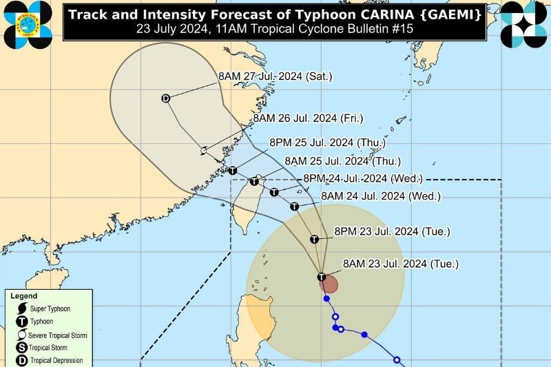
MANILA, Philippines — Typhoon Carina (international name: Gaemi) has slightly intensified and is forecast to gradually accelerate as it continues to move north-northwestward on Tuesday, the state weather bureau said.
According to its 11 a.m. bulletin, PAGASA said the center of "Carina" was estimated to be 320 kilometers east of Basco, Batanes, packing maximum sustained winds of 140 km per hour near the center with gustiness of up to 170 km per hour.
The typhoon, which PAGASA expects to remain far from making landfall, is moving northward at 15 kph.
The combined weather disturbance of "Carina" and the southwest monsoon or habagat is expected to bring moderate to intense rainfall over various parts of western Luzon from Tuesday through Thursday, the state weather bureau said.
PAGASA has raised Tropical Cyclone Wind Signal No. 2 over several parts of Batanes, warning of gale-force winds between 62 to 88 kph within the next 24 hours. These are:
- Itbayat
- Basco
- Mahatao
- Uyugan
- Ivana
Meanwhile, Signal No. 1 has been raised over parts of Luzon, warning of strong winds between 39-61 kph within the next 36 hours.
- The rest of Batanes
- Cagayan including Babuyan Islands
- Eastern portion of Isabela
- Northern portion of Ilocos Norte
- Northern portion of Aurora
- Northern portion of Catanduanes
The typhoon is forecast to make landfall over northern Taiwan between Wednesday evening and Thursday morning before exiting the Philippine Area of Responsibility (PAR).
PAGASA forecasts "Carina" to steadily intensify, potentially reaching its peak intensity before making landfall in Taiwan.


- Latest
- Trending