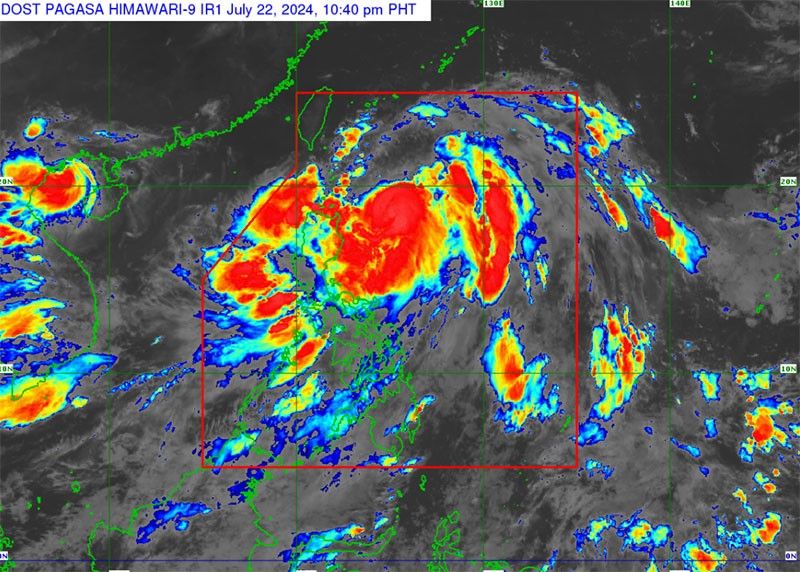
Carina intensifies into typhoon, leaves Philippines Thursday

MANILA, Philippines — Severe tropical storm Carina has intensified into a typhoon and is expected to maintain strength until it leaves the Philippine area of responsibility (PAR) on Thursday, according to the Philippine Atmospheric, Geophysical and Astronomical Services Administration (PAGASA).
In its 5 p.m. bulletin yesterday, PAGASA said the center of Typhoon Carina was located at 420 kilometers east of Tuguegarao City, Cagayan, with maximum sustained winds of 120 km per hour near the center and gustiness of up to 150 kph, as it is slowly moving north-northeastward.
At a briefing, PAGASA senior weather specialist Benison Estareja added that heavy to intense rains are expected in many parts of the country as Typhoon Carina (international name Gaemi) continues to enhance the southwest monsoon.
“It is expected to further intensify in the next few days while it is in the northern Philippine Sea where the ocean is hot. Until it exits PAR early Thursday, it will maintain its typhoon category,” Estareja said.
Almost the entire Luzon was affected by rains on Monday.
“Rains were also experienced in portions of Western Visayas, Negros Island Region. Rains also affected Basilan, Sulu, Tawi-Tawi and Zamboanga peninsula,” he said.
According to Estareja, Typhoon Carina is expected to be located 385 kilometers east of Calayan, Cagayan this morning, and by Wednesday morning it is expected to be around 360 kilometers southeast of Itbayat, Batanes.
There is a low possibility that Carina will make landfall.
He said the typhoon will bring strong winds in the eastern portion of Cagayan Valley, particularly eastern Isabela, eastern Cagayan, Babuyan Island and Batanes.
Tropical cyclone wind signal No. 1 was hoisted in Batanes, eastern portion of mainland Cagayan including the eastern portion of Babuyan Islands and the northeastern portion of Isabela.
“In terms of rains, the southwest monsoon is mainly the cause of strong rains in many areas in the country,” Estareja added.
He said orange or intense rains were experienced in Romblon yesterday while yellow or heavy rains were issued in Zambales, Bataan, Cavite, Batangas, Oriental Mindoro, Albay, Aklan, Antique and Capiz.
“We do not discount the possibility of heavy rainfall warnings in other parts of Luzon. In Romblon, we are alerting fellow citizens amid the threat of flood and high chance of flooding in low-lying areas with yellow rainfall warnings,” Estareja said.
He said by Wednesday, Typhoon Carina will continue to enhance the southwest monsoon, bringing heavy to intense rains in the western side of Luzon, including the Ilocos region, Abra, Benguet, Zambales, Bataan and Occidental Mindoro.
“We also expect rains in Batanes because of Typhoon Carina and here in Metro Manila, moderate to heavy rains are also expected, as well as in Apayao, Tarlac, Nueva Ecija, Pampanga, Rizal, Cavite, Batangas and Calamian Island,” Estareja added.
At the same time, the weather specialist said that the strong winds will result in big waves up to 3.5 meters.
“We expect moderate to rough seas in Luzon and western portion of Visayas, up to 3.5 meters or equivalent to as high as a first story building. Affected areas also cover Cagayan Valley, Batanes, eastern side of Luzon and Bicol region,” Estareja said.
High alert
Two Philippine Coast Guard (PCG) districts in Luzon have been placed on high alert as they prepare for possible search and rescue (SAR) operations as Typhoon Carina continues to move over the Philippine Sea.
The PCG said in a statement that both Coast Guard District Northwestern Luzon, headed by Captain Ivan Roldan, and Coast Guard District Northeastern Luzon, led by Captain Ludovico Librilla Jr., have placed their personnel on high alert.
All personnel assigned in their stations and substations have been instructed to maintain readiness by activating their Deployable Response Groups and preparing their boats, vehicles and gear in case there is a need to conduct SAR operations.
“Essential first aid and rescue equipment, as well as radio communication devices, are fully operational in case of emergencies,” Roldan said.
Librilla reminded local fishermen and residents of flood-prone areas to take safety precautionary measures.
The PCG suspended all trips of all types of vessels, including small craft with 250 gross tonnage and below, plying the eastern seaboards of Northern Quezon, particularly in Patnanungan and Jomalig areas.
Yesterday, the PCG had recorded 70 people stranded in Southern Tagalog and Bicol because of Typhoon Carina.
By noon, the PCG said 22 people and three rolling cargoes were stranded at the Port of San Andres in Quezon province, which is under the jurisdiction of the PCG District Southern Tagalog.
The PCG District Bicol said that there are 48 passengers, drivers and helpers waiting, as well as four rolling cargoes, at the Port of Pasacao in Camarines Sur.
Red alert
The Office of Civil Defense (OCD) in Cagayan Valley yesterday placed a red alert status in the provinces of Cagayan, Batanes and Isabela due to the possible effects of Typhoon Carina.
Leon Rafael, OCD regional director, reported that the eastern portion of mainland Cagayan, Santa Ana, Gattaran, Baggao, Peñablanca, Lal-lo, Gonzaga and the northeastern portion of Isabela such as Divilacan, Palanan and Maconacon were already under storm signal one.
Rafael, chairman of Cagayan Valley Disaster Risk Reduction and Management Council, said that aside from Cagayan and Isabela, Batanes is also preparing for the possible effects of the typhoon.
People in the northern provinces are being cautioned that rivers may swell because of the rains Typhoon Carina is bringing. PAGASA has issued a flood advisory for the highland Cordillera Region.
Affected water courses are the rivers and tributaries in Upper Abra, Tineg and Ikmin, Abra; rivers and tributaries particularly in Upper Bauang near La Union; all rivers and tributaries in Ifugao, Kalinga and Mountain Province.
Angat Dam
The water level of Angat Dam increased by 3.77 meters in just four days after it reached 176.97 meters amid rains brought by Typhoon Carina and the southwest monsoon.
As of 8 a.m. yesterday, the water elevation of Angat Dam had improved by 0.17 meters compared to its previous level of 176.80 meters.
It increased by 0.46 meters on Sunday, 1.34 meters on Saturday, and 1.34 meters on Friday.
The current water level of Angat Dam is still 3.03 meters below its minimum water level of 180 meters.
Meanwhile, Meralco has encouraged the public to keep communication lines open and fully charge their mobile phones, laptops, radios and other communication devices.
Customers within the franchise coverage of Meralco may report power outages and other concerns through its official social media pages, or text at 09209716211 or 09175516211; as well as contact the Meralco hotline at 16211 and 8631-1111. — Evelyn Macairan, Jun Elias, Artemio Dumlao, Brix Lelis, Rudy Santos
- Latest
- Trending


