Rain showers expected on SONA day due to ‘Carina’ — PAGASA
MANILA, Philippines — Rain showers are expected due to Severe Tropical Storm Carina (international name: Gaemi) on the day of President Ferdinand Marcos Jr.’s third State of the Nation Address.
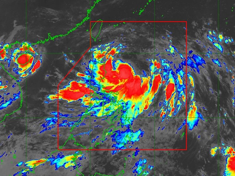
State weather bureau PAGASA said that Carina has developed into a severe tropical storm on Sunday evening. As of 4 a.m. on Monday, Carina was spotted 420 kilometers east of Tuguegarao City, Cagayan.
Moving north northwestward, the storm has maximum sustained winds of 100 kilometers per hour (kph) near the center, gustiness of up to 125 kilometers per hour and a central pressure of 990 hPa.
It is expected to steadily intensify over the next four days, reaching the typhoon category within 24 hours.
PAGASA hoisted Tropical Cyclone Wind Signal No. 1 over the following areas:
- Eastern portion of mainland Cagayan (Santa Ana, Gattaran, Baggao, Peñablanca, Lal-Lo, Gonzaga)
- Northeastern portion of Isabela (Divilacan, Palanan, Maconacon)
Areas under Wind Signal No. 1 are warned of minimal to minor threats to life and property.
The enhanced habagat will also bring strong to gale-force gusts over the following areas:
- Monday: MIMAROPA, Bicol Region, Western Visayas, Northern Samar and the northern portion of Samar
- Tuesday: Zambales, Bataan, Aurora, Metro Manila, CALABARZON, MIMAROPA, Bicol Region and Visayas
- Wednesday: Ilocos Region, Abra, Benguet, Nueva Vizcaya, Quirino, Central Luzon, Metro Manila, CALABARZON, MIMAROPA, Bicol Region and Visayas
In the next 24 hours, Carina and the enhanced southwest monsoon may cause moderate to rough seas over the northern and eastern seaboards of northern Luzon.
Mariners operating motorbancas and similarly-sized vessels are urged to take precautionary measures while at sea and, if possible, avoid navigating in these conditions.
Carina is forecasted to move generally north northwestward to northward until mid-Wednesday July 24, while gradually accelerating. It is expected to turn northwestward for the remainder of the forecast period.
The tropical storm is likely to remain far from the Philippine landmass and exit the Philippine Area of Responsibility (PAR) on Wednesday evening or early Thursday morning.
Carina is anticipated to pass near or over the southern islands of the Ryukyu archipelago and close to northern Taiwan after exiting the PAR, moving towards southeastern China.
Expected rain showers
The rest of the country can expect rain showers due to the enhanced southwest monsoon brought by Carina.
Cagayan Valley, the Bicol Region, Aurora, Quezon and the rest of the Cordillera Administrative Region can expect cloudy skies with scattered rain showers and thunderstorms due to the storm.
Western Visayas, Zamboanga Peninsula, Negros Island Region, Basilan, Sulu, Tawi-Tawi and the rest of MIMAROPA should anticipate cloudy skies with scattered rain showers and thunderstorms from the southwest monsoon.
PAGASA cautioned residents in these areas about potential flash floods or landslides triggered by moderate to occasionally heavy rainfall.
La Union, Pangasinan, Benguet, Zambales, Bataan, Cavite, Batangas and Occidental Mindoro may experience monsoon rains due to the habagat.
Metro Manila, Rizal, Laguna, Pampanga, Tarlac, Nueva Ecija, Bulacan, Abra, the rest of the Ilocos Region, and the Calamian Islands should also expect occasional rains from the same weather systems.


- Latest
- Trending