Storm Carina intensifies, enhances habagat
MANILA, Philippines — The Philippine Atmospheric, Geophysical and Astronomical Services Administration (PAGASA) yesterday said that Tropical Storm Carina is expected to exit the Philippine area of responsibility (PAR) by midweek, adding that it will enhance the southwest monsoon bringing rains to many areas in the country.
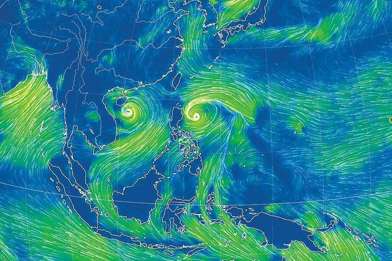
In a briefing, PAGASA weather specialist Veronica Torres said that Carina (international name Gaemi) may reach severe tropical storm category by Sunday night, and typhoon category by Monday evening.
Under PAGASA’s tropical cyclone wind signal system, a typhoon is declared if it has sustained winds of 118 to 184 kilometers an hour; severe tropical storm, 89 to 117 km/h; tropical storm, 62 to 88 km/h, and tropical depression less than 61 km/h.
“Carina may leave the Philippine area of responsibility by Wednesday night or Thursday early morning, as we do not discount the possibility of its rapid intensification,” Torres added.
She said Carina is forecast to move generally north northwestward to northward.
Torres said that Carina slightly intensified over the Philippine Sea, as its center was located at 350 kilometers east of Casiguran, Aurora with maximum sustained winds of 85 km/h near the center, gustiness of up to 115 km/h, as it is moves westward at 20 km/h.
“After 24 hours, we expect Carina to be located 345 kilometers east of Tuguegarao City, Cagayan; and then after 48 hours, 295 kilometers east southeast of Basco, Batanes; and then by July 24, 345 kilometers east northeast of Itbayat, Batanes; and by July 25, it is already outside PAR at 565 kilometers north of Itbayat, Batanes,” Torres said.
She added that the enhanced southwest monsoon will bring strong rains in the western section of Luzon.
“Currently, Carina is affecting east and northern Luzon. No wind signal has been hoisted at this time, but we don’t rule out the possibility of raising signal number 1 in extreme Northern Luzon and the northeastern portion of mainland Cagayan,” Torres said.
According to Torres, the tropical depression outside PAR, or formerly “Butchoy” will also enhance the southwest monsoon, also known as habagat.
“The southwest monsoon being enhanced by Carina and Butchoy will bring strong winds today (Sunday) until tomorrow (Monday) noon in Mimaropa, Bicol region and Western Visayas; by Monday noon to Tuesday noon in Zambales, Bataan, Metro Manila, Calabarzon, Mimaropa, Bicol region and Visayas and then Tuesday noon until Wednesday noon in Ilocos region, Central Luzon, Metro Manila, Calabarzon, Mimaropa, Bicol region and Visayas,” she said.
Based on the latest bulletin of PAGASA, heavy rainfall of 50 to 100 millimeters is expected in mainland Cagayan and Babuyan Islands until Monday noon while accumulated rainfall of 100 to 200 mm is expected from Monday noon to Tuesday noon in Batanes; and 50 to 100 mm in Babuyan Islands.
“Forecast rainfall is generally higher in elevated or mountainous areas. Under these conditions, flooding and rain-induced landslides are possible especially in areas that are highly or very highly susceptible to these hazards as identified in official hazard maps and in localities that experienced considerable amounts of rainfall for the past several days,” Torres said.
Storm damage to agriculture reaches P10.33 million
The damage of southwest monsoon and Tropical Depressions Butchoy and Carina to the agriculture sector in Mimaropa, Western Visayas, Zamboanga peninsula and Caraga regions has reached P10.33 million, according to the Department of Agriculture (DA).
Based on the report of DA’s Operations Centers, the rains and flooding brought by the two cyclones and the habagat have resulted in the production loss of 189 metric tons covering 1,102 hectares of agricultural areas of corn, corn and high value crops, and affecting 873 farmers.
According to the DA, the bulk of the damage came from rice with P8.76 million or 87 percent, affecting 1,082 hectares and production loss of 117 metric tons.
It was followed by high value crops with P1.05 million damage or 10 percent affecting five hectares and production loss of 51 metric tons.
The damage to corn production totaled to P513,020 covering 16 hectares and volume loss of 21 metric tons.
“These values are subject to validation,” the DA said, giving assurance that best possible efforts are being undertaken to carry out assistance and appropriate interventions to the affected farmers.
“The Department will promptly deploy the following forms of assistance… 72,174 bags of rice seeds, 39,546 bags of corn seeds, 59,600 pouches and 1,966 kilograms of vegetable seeds,” the DA added.
The affected farmers can avail themselves of the Survival and Recovery Loan Program from the Agricultural Credit Policy Council with loanable amount of up to P25,000 payable in three years at zero interest, the DA said.
At least P1 billion from the Quick Response Fund will be tapped for the rehabilitation of affected areas, and will also have “available funds from the Philippine Crop Insurance Corp. to indemnify affected farmers,” the agency noted.


- Latest
- Trending