Kabayan strands 5,400 as sea voyages suspended

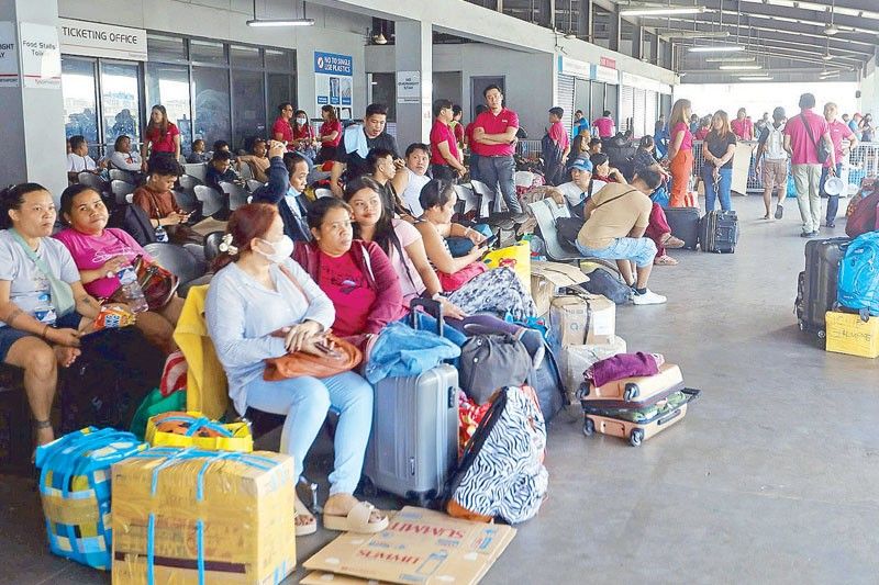
MANILA, Philippines — About 5,400 people were stranded in various seaports in the Visayas and Mindanao as of noon yesterday as Tropical Depression Kabayan weakened and continued to move across the West Philippine Sea, according to the Philippine Coast Guard.
PCG spokesman Rear Admiral Armand Balilo said they have received reports that some 5,400 people were stranded in various ports across the country, of whom around 2,000 were in the Visayas and Mindanao while a bigger bulk of around 3,400 were in the North Harbor in Manila.
“Once the PAGASA (Philippine Atmospheric and Geophysical Astronomical Services Administration) says that the weather has improved, then we would lift the suspension of sea travel and allow vessels to resume their travel,” Balilo added.
He said the PCG is on heightened alert because of Oplan Biyaheng Ayos: Pasko and that the safety and security of the travelers and the vessels’ crew are their primary concern.
As this developed, domestic shipping line 2Go is appealing to the PCG and other concerned government agencies to review the policy on suspending sea travel during inclement weather because it delays the scheduled departure of their vessels and causes inconvenience to their passengers.
Sharon Ngo, vice president-business unit head for 2Go Sea Solutions, explained that their two ships at the North Harbor are fully booked.
The M/V Masagana that would ply the Manila-Cebu-Cagayan de Oro route and the M/V Michael the Archangel that would traverse the Manila-Dumaguete-Zamboanga route were supposed to have left port last Sunday.
“We agreed for our passengers to embark (on) the two vessels and our ships are ready to go, but we are still waiting for the ‘go signal’ for our ships to proceed with their travel,” Ngo said.
Each of 2Go’s vessels could accommodate around 1,600 to 1,800 passengers.
The shipping line has two other vessels waiting at the anchorage area. They were scheduled to leave at 6 p.m. yesterday, but could not yet dock at the port because the M/V Masagana and M/V Michael the Archangel were occupying their slots.
The company was unable to follow its schedule because several provinces in the Visayas and Mindanao have been placed under Public Storm Warning Signal No. 1 because of Kabayan.
The PCG’s 2013 Memorandum Circular on the Guidelines on Movement of Vessels During Heavy Weather partially states that “no vessel of any type or tonnage shall be allowed to sail except to take shelter, as the situation may warrant, when PSWS No. 1 or higher is hoisted within its point of origin, the intended route and point of destination.”
“We are abiding by the safety regulations of the Coast Guard, and we know that safety is non-negotiable … and the convenience of our riding public and their safety are important. We are just asking the PCG and the government to review their policy and see if it could be amended that could benefit us (2Go) without sacrificing the safety and convenience of the riding public,” Ngo said.
“We ask for two things. First, to request them to review the capability of big ships and decide which of the ships could travel during PSWS No. 1 and bring the passengers safely to their destinations. Second, for them to consider that it takes 23 to 24 hours to travel from Manila to Cebu, and if by the time they reach the destination the tropical depression would already be gone and the weather would already be clear,” she added.
Ngo also mentioned that 2Go’s vessels could also “slow steam” or reduce speed in case there is still bad weather prevailing in their route or the port of destination.
Kabayan weakens
Kabayan weakened into a low-pressure area (LPA) at 1 p.m. yesterday, according to PAGASA.
PAGASA said that the LPA was located within the vicinity of Unnamed Road, Impasug-ong as it moved northwestward at 25 kilometers per hour with maximum sustained winds of 55 kph near the center and gustiness of up to 70 kph.
All tropical cyclone wind signals have been lifted, according to the state weather bureau.
It said the LPA was forecast to track generally northwestward or west northwestward traversing the Philippine archipelago over the next two days.
“On the track forecast, the LPA will continue to cross the rugged terrain of Mindanao and emerge over the Sulu Sea between Monday afternoon and evening. Afterwards, a slight improvement in the environmental conditions may allow this disturbance to reorganize and re-develop into a tropical depression,” it added.
PAGASA said the LPA would move across the Sulu Sea south of Cagayancillo Islands.
“The LPA is forecast to make another cross over central or southern Palawan by (Tuesday) morning or afternoon, then emerge over the West Philippine Sea shortly thereafter. It may pass near or over Kalayaan Islands between Tuesday evening and Wednesday morning,” it added.
The state weather bureau added that the northeast monsoon is currently affecting Northern and Central Luzon while the shear line would bring rains in the eastern section of Southern Luzon.
It said Surigao del Sur, Surigao del Norte, Dinagat Islands, Agusan del Sur, Davao del Norte, Davao de Oro and Davao Oriental would experience rains up to 200 millimeters while rainfall in Central Visayas, Biliran, Leyte, Southern Leyte, Zamboanga del Norte, Northern Mindanao, Davao City, Cotabato, Lanao del Sur, the southern portions of Samar and Eastern Samar and the rest of Caraga, Davao Oriental, Davao de Oro, and Davao del Norte, mainland Palawan, Cuyo islands, Cagayancillo Islands and Kalayaan would reach between 50 and 100 millimeters.
“Forecast rainfall is generally higher in elevated or mountainous areas. Under these conditions, flooding and rain-induced landslides are likely, especially in areas that are highly susceptible to these hazards and in localities that experienced considerable amounts of rainfall for the past several days,” PAGASA said.
It added that the LPA would enhance the shear line and may bring heavy rainfall over the eastern portion of Southern Luzon.
A gale warning is in effect for the coastal waters along the seaboard of Northern Luzon, the eastern and central seaboards of the Visayas and the eastern seaboards of Central Luzon, Southern Luzon and Mindanao, according to the state weather bureau.
PAGASA weather specialist Veronica Torres said Kabayan made landfall over Barangay Concepcion, Manay, Davao Oriental at 9:30 a.m. yesterday.
Torres added that Kabayan developed into a tropical storm last Sunday night before it weakened into a tropical depression.
More destructive
Meanwhile, the strongest typhoons in recent years would pale compared with those coming in the future, which would be more destructive due to climate change, a new local study warned.
New research by the University of the Philippines-Diliman College of Science’s Institute of Environmental Science and Meteorology (UPD-CS IESM) said the Philippines should brace for typhoons with higher cyclone damage potential (CDP) than typhoons at present.
The study by professors Rafaela Jane Delfino and Gerry Bagtasa and colleagues from the United Kingdom looked at the CDPs of three of the deadliest super typhoons in the past decade: Yolanda of 2013, Pablo of 2012 and Ompong of 2018.
CDP is a metric that tracks several factors, including the size of the cyclone and the wind speeds.
Using data from recent typhoons that hit the Philippines, as well as projections and considering other factors such as atmospheric temperature, sea surface temperature, pressure and relative humidity, the scientists “conclusively” linked climate change to the intensification of the three typhoons analyzed.
Had they occurred in a “future where the climate is forecast to be warmer and more humid, based on multiple climate projections for the years 2070 to 2099,” the potential damage of the three typhoons would be more intense and would linger over land longer, therefore causing more damage, according to the UPD-CS IESM scientists.
“Based on our simulations, it is found that the most damaging tropical cyclones like Haiyan (Yolanda), Bopha (Pablo) and Mangkhut (Ompong) will have higher wind-related damage potential in the future,” the researchers concluded in their paper.
They cited as an example under one forecast model that the CDP from a future cyclone similar to Yolanda would cause 37 percent more damage than the one it caused in 2013.
Another simulation also showed Ompong having 270-kph wind speed compared to when it hit in 2018 with 205 kph under current climate conditions. The projections also showed an increase of as much as 50 kph in the maximum wind speeds of future typhoons like Yolanda and Pablo.
“Tropical cyclones of such intensity and damage potential in the future will have serious implications with the increasing exposure and vulnerability in the Philippines,” the researchers added, calling for further research using other models and typhoon data sets.
The Philippines is located along the path of tropical cyclones, making it prone to storms and typhoons, with about 20 ravaging the archipelago yearly. — Bella Cariaso, Neil Jayson Servallos
- Latest
- Trending


