Signal No. 3 up in Itbayat as 'Jenny' weakens
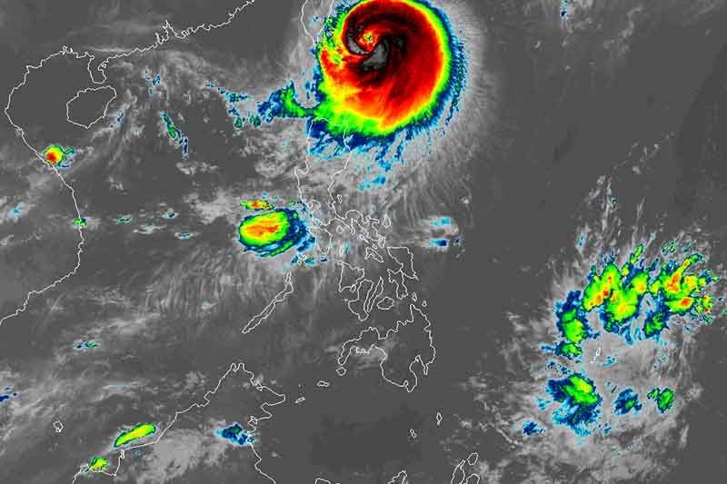
MANILA, Philippines (Update 1: 11:15 a.m.) — The town of Itbayat in Batanes remained under Signal No. 3 as Typhoon Jenny (international name: Koinu) weakened slightly, PAGASA said Wednesday morning.
Jenny was last spotted 210 kilometers east northeast of Itbayat, with peak winds of 150 km per hour near the center and gusts of up to 185 kph. It was moving west northwest at 10 kph.
The state weather bureau placed the following areas under wind signals:
Signal No. 3
- Northern portion of Batanes (Itbayat)
Residents of Itbayat may experience moderate to significant impacts from storm-force winds.
Signal No. 2
- Rest of Batanes
- Northern portion of Babuyan Islands (Babuyan Island, Calayan Island)
Minor to moderate impacts from gale-force winds are possible in these areas.
Signal No. 1
- Rest of Babuyan Islands
- Northern portion of mainland Cagayan (Santa Ana, Gonzaga, Buguey, Santa Teresita, Lal-Lo, Camalaniugan, Pamplona, Claveria, Aparri, Ballesteros, Abulug, Allacapan, Sanchez-Mira, Santa Praxedes, Lasam, Gattaran)
- Northern portion of Apayao (Calanasan, Pudtol, Luna, Santa Marcela, Flora)
- Northern portion of Ilocos Norte (Piddig, Bangui, Vintar, Burgos, Pagudpud, Bacarra, Adams, Pasuquin, Carasi, Dumalneg, Laoag City)
Minimal to minor impacts from strong winds may occur in these areas.
What to expect
Jenny is expected to bring heavy rains of up to 200 millimeters to Batanes and up to 100 mm to the northern portion of Babuyan Islands on Wednesday.
The typhoon will continue to enhance the southwest monsoon, causing occasional to monsoon rains over the western portions of Luzon in the next three days.
PAGASA warned of possible flooding and landslides, especially in areas identified as susceptible to these hazards, and in places that have received substantial rainfall in the past few days.
Residents of the southern portion of Aurora, Bataan, Metro Manila, Occidental Mindoro, Kalayaan Islands, Romblon, most of CALABARZON, and portions of Bicol region will experience gusty conditions due to the enhanced southwest monsoon on Wednesday.
The typhoon is expected to make landfall over the southern portion of Taiwan Thursday morning and then leave the Philippine Area of Responsibility by afternoon or evening.
Forecast position
- Oct. 4, 2023 8:00 PM - 160 km north of Itbayat, Batanes
- Oct. 5, 2023 8:00 AM - 190 km northwest of Itbayat, Batanes or in the vicinity of Pingtung County, Taiwan
- Oct. 5, 2023 8:00 PM - 320 km northwest of Itbayat, Batanes (outside PAR)
- Oct. 6, 2023 8:00 AM - 445 km west northwest of Itbayat, Batanes (outside PAR)
- Oct. 6, 2023 8:00 PM - 535 km west northwest of Itbayat, Batanes (outside PAR)
- Oct. 7, 2023 8:00 AM - 635 km west northwest of Itbayat, Batanes (outside PAR)
- Oct. 8, 2023 8:00 AM - 715 km west northwest of Itbayat, Batanes (outside PAR)
- Oct. 9, 2023 8:00 AM - 775 km west northwest of Itbayat, Batanes (outside PAR)


- Latest
- Trending