'Goring' threatens northern Luzon as another storm approaches
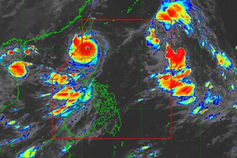
MANILA, Philippines (Update 1, 12:56 p.m.) — Super Typhoon Goring (international name: Saola) will continue to threaten the northern part of the country on its way out of the Philippine Area of Responsibility as another cyclone approaches, the state weather bureau said Wednesday morning.
In its 11 a.m. bulletin, PAGASA said Goring was last spotted 90 kilometers west southwest of Basco in Batanes with peak winds of 195 km per hour near the center and gusts of up to 240 kph.
Here are the remaining areas under wind signals:
Signal No. 2
- Batanes
- Babuyan Islands
Gale-force winds could potentially cause minor to moderate impacts in these areas.
Signal No. 1
- Ilocos Norte
- Northern portion of Abra (Tineg, Lagayan, Danglas)
- Ilocos Sur (Sinait, Cabugao, San Juan)
- Apayao
- Northern and central portion of Cagayan (Amulung, Santo Niño, Piat, Rizal, Lasam, Gattaran, Santa Ana, Gonzaga, Lal-Lo, Santa Teresita, Buguey, Baggao, Alcala, Camalaniugan, Aparri, Allacapan, Ballesteros, Santa Praxedes, Claveria, Sanchez-Mira, Pamplona, Abulug)
Areas under Signal No. 1 may experience possible minimal to minor impacts from strong winds.
What to expect
More than 200 millimeters or over eight inches of rain is forecast to fall along the southern portion of Batanes and the northwestern portions of Babuyan Islands.
Meanwhile, residents of Ilocos Norte, the northern portion of Apayao, the extreme northern northwestern portion of mainland Cagayan and the rest of Batanes and Babuyan Islands may have 100 to 200 of accumulated rainfall.
Between 50 and 100 mm of rain is projected to fall along Ilocos Sur, Abra, the northwestern portion of mainland Cagayan and the rest of Apayao.
PAGASA said that floods and landslides may occur in areas that are highly vulnerable to these hazards, and in places that received substantial amounts of rainfall in the past few days.
The southwest monsoon enhanced by Goring will continue to bring occasional or monsoon rains and gusty conditions over other parts of the country.
Weather forecasters warned there is “a moderate to high risk of storm surge which may cause flooding in the low-lying and exposed coastal areas of Batanes and the northern and western portions of Babuyan Islands.”
As Goring is expected to leave the Philippine Area of Responsibility Wednesday night or Thursday morning, a severe tropical storm called Haikui may enter the PAR region this afternoon. Once inside the country’s area of responsibility, it will be called Hanna.
PAGASA said that the cyclone will move northwest and is “less likely” to have a direct effect on the country. But it may enhance the southwest monsoon, which will cause occasional or monsoon rains to persist over the western portion of Luzon and Visayas.
Goring's forecast position
- August 30, 2023 8:00 PM - 225 km west of Itbayat, Batanes (outside PAR)
- August 31, 2023 8:00 AM - 360 km west of Itbayat, Batanes (outside PAR)
- August 31, 2023 8:00 PM - 470 km west northwest of Itbayat, Batanes (outside PAR)
- September 1, 2023 8:00 AM - 590 km west northwest of Itbayat, Batanes (outside PAR)
- September 1, 2023 8:00 PM - 700 km west northwest of Itbayat, Batanes (outside PAR)
- September 2, 2023 8:00 AM - 770 km west northwest of Laoag City, Ilocos Norte (outside PAR)
- September 3, 2023 8:00 AM - 850 km west northwest of Northern Luzon (outside PAR)
- September 4, 2023 8:00 AM - 940 km west northwest of Northern Luzon (outside PAR)
— Gaea Katreena Cabico


- Latest
- Trending