Signal No. 4 raised as ‘Goring’ intensifies
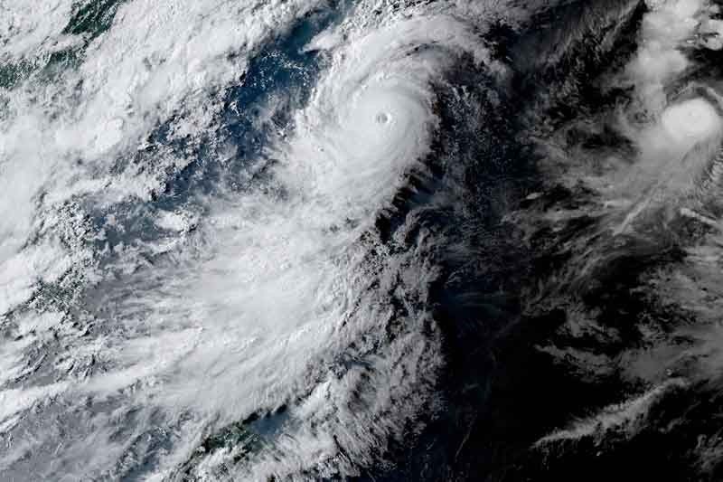
MANILA, Philippines — State weather bureau PAGASA placed the northeast portion of Babuyan Islands under Wind Signal No. 4 Tuesday afternoon as Typhoon Goring (international name: Saola) slightly intensified.
Goring was last seen 165 kilometers to the east of Calayan in Cagayan, with peak winds increasing to 165 kph near the center and gusts increasing to 205 kph, PAGASA said in its 5 p.m. bulletin.
According to the state weather bureau, the typhoon may “persist in strength.” But the agency is not ruling out that Goring may gradually re-intensify and reach the super typhoon category.
PAGASA raised wind signals in parts of Northern Luzon due to the cyclone.
Signal No. 4
- northeastern portion of Babuyan Islands (Babuyan Island)
Residents here may experience significant threat to life and property due to Goring’s winds.
Signal No. 3
- southern portion of Batanes (Sabtang, Uyugan, Ivana, Mahatao, Basco)
- rest of Babuyan Islands
Storm-force winds may result in moderate to significant impacts in the area.
Signal No. 2
- northeastern portion of mainland Cagayan (Santa Ana, Gonzaga, Santa Praxedes, Claveria, Sanchez-Mira, Pamplona, Abulug, Ballesteros, Aparri, Buguey, Camalaniugan, Santa Teresita, Allacapan, Lal-Lo, Lasam, Gattaran, Baggao, Peñablanca)
- rest of Batanes
- northern portion of Ilocos Norte (Pagudpud, Adams, Bangui, Dumalneg)
- northern portion of Apayao (Calanasan, Luna, Santa Marcela, Flora, Pudtol)
Gale-force winds could potentially cause minor to moderate impacts in these areas.
Signal No. 1
- northern and eastern portion of Isabela (Dinapigue, San Mariano, Ilagan City, Tumauini, San Pablo, Cabagan, Maconacon, Divilacan, Palanan, Santa Maria, Santo Tomas, Quezon, Delfin Albano)
- rest of Ilocos Norte
- rest of Cagayan
- rest of Apayao
- northern portion of Abra (Tineg, Lagayan, Lacub, Malibcong)
- northern portion of Kalinga (Balbalan, Pinukpuk, Rizal, City of Tabuk)
Areas under Signal No. 1 may experience possible minimal to minor impacts from strong winds.
What to expect
Up to 200 millimeters or around eight inches of rain is forecast to fall along Babuyan Islands until Wednesday afternoon.
Meanwhile, residents of Batanes, Ilocos Norte, the northern portion of Abra, Apayao, and the northern and eastern portions of mainland Cagayan may have 50 to 100 mm of accumulated rainfall.
PAGASA warned that floods and landslides may occur in areas that are highly vulnerable to these hazards, and in places that received substantial amounts of rainfall in the past few days.
The southwest monsoon enhanced by Goring will continue to bring occasional or monsoon rains over the western portions of central Luzon, southern Luzon, and Visayas over the next three days.
The enhanced southwest monsoon will also bring gusty conditions over the following areas that are not under any wind signal: Aurora, Bataan, Bulacan, Metro Manila, Calabarzon, Mimaropa, Bicol region, Visayas, Dinagat Islands, Camiguin and most of Zamboanga Peninsula.
The latest track forecast indicates that Goring may pass very close or make landfall in the vicinity of Babuyan Island. A slight northward shift may bring the typhoon’s eye and eyewall region to the southern portion of Batanes.
Goring is expected to leave the Philippine Area of Responsibility Wednesday evening or Thursday morning.
Meanwhile, the tropical storm called Haikui may enter PAR Wednesday morning. Once inside the country’s area of responsibility, it will be called Hanna.
PAGASA said it is “less likely” to have a direct effect on the country, but it may enhance the southwest monsoon, which will cause occasional or monsoon rains to persist over the western portion of Luzon and Visayas.
Goring’s forecast position
- Aug. 30, 2023 2:00 a.m. - over the coastal waters of Babuyan Island
- Aug. 30, 2023 2:00 p.m. - 135 km west of Basco, Batanes
- Aug. 31, 2023 2:00 a.m. - 265 km west of Itbayat, Batanes (outside PAR)
- Aug. 31, 2023 2:00 p.m. - 405 km west northwest of Itbayat, Batanes (outside PAR)
- Sept. 1, 2023 2:00 a.m. - 510 km west northwest of Itbayat, Batanes (outside PAR)
- Sept. 1, 2023 2:00 p.m. - 605 km west northwest of Itbayat, Batanes (outside PAR)
- Sept. 2, 2023 2:00 p.m. - 745 km northwest of Laoag City, Ilocos Norte (outside PAR)
- Sept. 3, 2023 2:00 p.m. - 895 km west northwest of northern Luzon or in the vicinity of Guangdong, China (outside PAR)
— Gaea Katreena Cabico


- Latest
- Trending