PAGASA: Goring weakens into typhoon, but expected to re-intensify
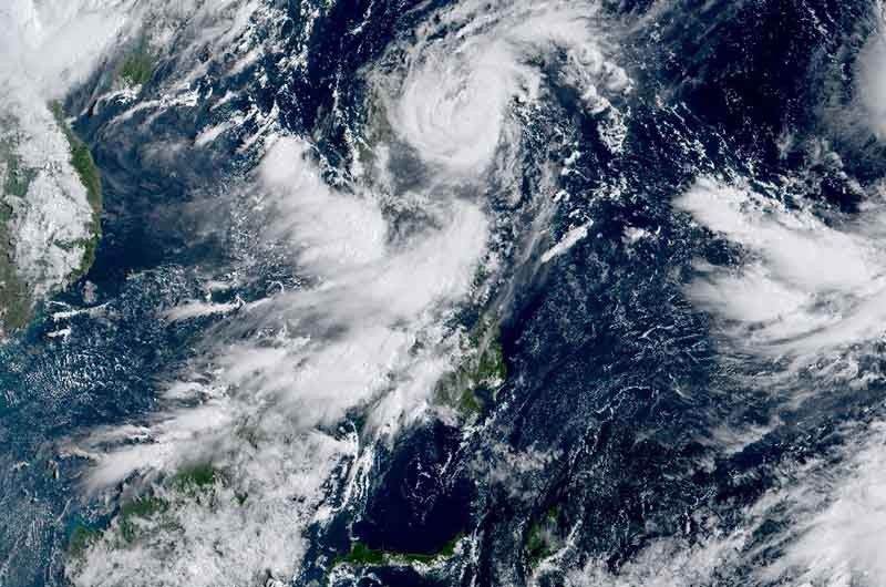
MANILA, Philippines (Update 1 11:39 a.m.) — Typhoon Goring (international name: Saola) continued to weaken Monday morning as it continued its counterclockwise loop over the Philippines Sea, the state weather bureau said.
Goring was last spotted 245 kilometers to the east of Casiguran in Aurora, with peak winds of 155 kilometer per hour near the center and gusts of up to 190 kph. It was heading north northwest at 15 kph.
According to PAGASA, the cyclone may weaken further in the next 12 hours due to the upwelling of cooler ocean waters and the onset of dry air intrusion. But it is expected to re-intensify as it turns northwest.
The weather agency placed the following areas under Wind Signal No. 1:
- Batanes
- Babuyan Islands
- Northern and eastern portions of mainland Cagayan (Camalaniugan, Pamplona, Gonzaga, Santa Teresita, Baggao, Buguey, Santa Ana, Claveria, Aparri, Ballesteros, Abulug, Sanchez-Mira, Santa Praxedes, Allacapan, Lal-Lo, Lasam, Peñablanca, Iguig, Amulung, Gattaran, Alcala)
- Eastern portion of Isabela (Dinapigue, San Mariano, San Guillermo, Ilagan City, Tumauini, San Pablo, Cabagan, Maconacon, Divilacan, Palanan)
- Northern and central portions of Aurora (Casiguran, Dinalungan, Dilasag, Baler, Dipaculao, Maria Aurora, San Luis)
- Polillo Islands
- Northern and eastern portions of Camarines Norte (Capalonga, Jose Panganiban, Paracale, Vinzons, Talisay, Daet, Mercedes) including Calaguas Islands
- Northeastern portion of Camarines Sur (Siruma, Tinambac, Lagonoy, Garchitorena, Caramoan)
- Northern portion of Catanduanes (Panganiban, Caramoran, Viga, Bagamanoc, Pandan)
Minimal to minor impacts from strong winds are possible in any of these areas.
PAGASA said that higher wind signals may still be raised over extreme Northern Luzon, and the northern or northeastern portion of mainland Cagayan later today or Tuesday.
Nearly 8,000 people have been so far affected by Goring, the National Disaster Risk Reduction and Management Council reported.
What to expect
Goring will pass close to Batanes at or near its peak intensity between Wednesday evening and Thursday morning.
“Whether there’s a landfall or not, Goring will have a big impact on the residents of Batanes, so those living in the area should prepare now,” PAGASA weather specialist Obet Badrina said in Filipino.
Up to 100 millimeters or nearly four inches of rain is forecast to fall along the northeastern portion of mainland Cagayan today.
Goring will continue to enhance the southwest monsoon, which will bring occasional or monsoon rains over the western portions of Central Luzon, Southern Luzon and Visayas in the next three days.
The enhanced southwest monsoon will also continue to bring gusty conditions over the following areas that are not under any wind signal: Aurora, Bataan, Metro Manila, Calabarzon, Mimaropa, Bicol region, Visayas, Dinagat Islands, Camiguin, and most of Zamboanga Peninsula.
The agency also warned that the condition of the northern and eastern seaboards of Northern Luzon, the eastern seaboards of Central Luzon, the seaboards of Southern Luzon, and the western seaboard of Visayas is hazardous.
Goring will exit the Philippine Area of Responsibility on Thursday, and cross Taiwan Strait before making landfall over southeastern China.
Another cyclone
PAGASA is monitoring a tropical depression spotted 2,085 km to the east northeast of Eastern Visayas.
It may enter PAR on Wednesday evening or Thursday morning as a typhoon. Once it does, it will be called “Hannah”—the country’s eighth cyclone of the year.
The potential Hannah is less likely to directly affect the Philippines, but it may continue to enhance the southwest monsoon.
Around 20 cyclones typically enter or form within the Philippine Area of Responsibility each year. Scientists have warned that storms are becoming more powerful and destructive as the world becomes warmer because of climate change.
Forecast position
- August 28, 2023 8:00 PM - 310 km east of Tuguegarao City, Cagayan
- August 29, 2023 8:00 AM - 320 km east of Calayan, Cagayan
- August 29, 2023 8:00 PM - 155 km east Southeast of Basco, Batanes
- August 30, 2023 8:00 AM - Over the coastal waters of Itbayat, Batanes
- August 30, 2023 8:00 PM - 110 km northwest of Itbayat, Batanes
- August 31, 2023 8:00 AM - 260 km northwest of Itbayat, Batanes (outside PAR)
- September 1, 2023 8:00 AM - 415 km northwest of Itbayat, Batanes (outside PAR)
- September 2, 2023 8:00 AM - 600 km northwest of Itbayat, Batanes or in the vicinity of Guangdong, China (outside PAR)
— Gaea Katreena Cabico


- Latest
- Trending