Goring to peak this weekend

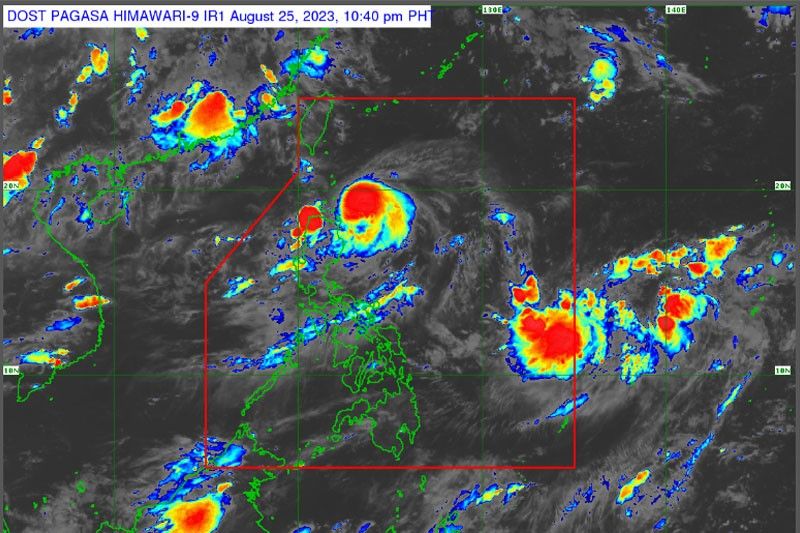
MANILA, Philippines — Tropical cyclone wind signal No. 1 has been hoisted over parts of Northern Luzon as Goring yesterday strengthened into a severe tropical storm and is forecast to continue to intensify into a super typhoon in the next few days.
The Philippine Atmospheric, Geophysical and Astronomical Services Administration (PAGASA) said signal No. 1 has been raised over Batanes, the eastern portion of Babuyan Islands, the eastern portion of mainland Cagayan and the eastern portion of Isabela. Higher wind signals are possible if Goring shifts its track further to the west.
Goring was monitored 260 kilometers southeast of Basco, Batanes. It is carrying maximum sustained winds of 110 kilometers per hour near the center and gustiness of up to 135 kph.
It is forecast to rapidly intensify due to a highly favorable environment and may attain maximum strength by Monday as a super typhoon.
Heavy rainfall is forecast today, with 50-100 mm of rainfall expected over Babuyan Islands and the northeastern portion of mainland Cagayan.
PAGASA said rainfall could reach 100-200 mm in the eastern portions of mainland Cagayan, Isabela and the northern portion of Aurora from today until Sunday afternoon.
State weather forecasters warned of possible flooding and rain-induced landslides, especially in areas that are highly or very highly susceptible to these hazards.
Goring will turn generally south today until tomorrow afternoon before looping northward towards the Luzon Strait on Tuesday.
The southwest monsoon is bringing occasional rains over the western portions of Central Luzon and Southern Luzon today.
Scattered rainshowers are forecast over Palawan, Occidental Mindoro, Zambales and Bataan. Metro Manila and the rest of the country may see isolated rainshowers due to the monsoon and localized thunderstorms.
Red alert
Cagayan Valley was placed on red alert status starting on Friday morning with the threat of Typhoon Goring, the Cagayan Valley Regional Disaster Risk Reduction and Management Council said in its the Memorandum Order No. 86 series of 2023.
Local DRRM offices were directed to conduct heightened monitoring in their respective areas of responsibility and strictly implement the “No sailing, fishing and swimming” policy.
All local disaster risk reduction and management councils were also told to submit reports of their preparedness measures and incident monitoring.
Those not directly affected or are not affected at all were also advised to organize humanitarian assistance and disaster response teams ready to extend assistance.
Local chief executives in Cagayan Valley were also told to perform their mandate in times of calamities. LDRRMOs are also to conduct Pre-Disaster Risk Assessment.
The “Charlie Protocol” was also activated in preparation for the arrival of Goring, where selected response clusters and different rescue assets were activated.
Food packs
Almost 10,000 family food packs (FFPs) have been prepositioned in places affected by Goring, the Department of Social Welfare and Development (DSWD) said yesterday.
In a report to DSWD Secretary Rex Gatchalian, DSWD Cagayan Valley regional director Lucia Alan said that a total of 9,778 FFPs have been prepositioned in Batanes.
This is broken down as Basco-1,306 FFPs; Itbayat- 1,322; Ivana-1,100; Mahatao- 1,094; Sabtang- 1,203 and Uyugan- 1,167 for a total of 7,700 FFPs. An additional 2,078 food packs were also sent to the Batanes provincial capitol.
Alan also reported prepositioned FFPs to Isabela province coastal municipalities of Divilacan with 1,000 boxes of FFPs; Maconacon with 154 and Palanan with 500, while 1,246 packs were sent by boat to Isabela proivnce.
“For Calayan Island, we have prepositioned 2,900 FFPs while 150 FFPs were sent to Barangay Fuga of Aparri, Cagayan,” he added.
Earlier, Gatchalian directed concerned DSWD regional directors to brace p for Goring by beefing up their stockpile of food packs. — Artemio Dumlao, Sheila Crisostomo
- Latest
- Trending


