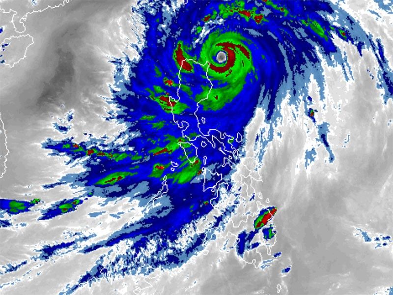
Signal No. 5 remains in part of Babuyan Islands as 'Egay' threatens northern Luzon

MANILA, Philippines — State weather bureau PAGASA reported Tuesday afternoon that Super Typhoon Egay has maintained its strength while posing an imminent threat to northern Luzon.
As of 4 p.m. Tuesday, Egay was spotted 190 kilometers east of Aparri, Cagayan, with peak winds of 185 kilometers per hour near the center and gusts of up to 230 kph.
Moving northwestward at 20 kph, the super typhoon is forecast to make landfall or pass very close to Babuyan Islands-northeastern mainland Cagayan area between late Tuesday or Wednesday morning.
Several areas remain under tropical cyclone wind signals.
Signal No. 5 (Areas experiencing extreme impacts from typhoon-force winds)
- eastern portion of Babuyan Islands (Camiguin Island)
Signal No. 4 (Significant to severe impacts from typhoon-force winds)
- northern portion of Cagayan (Santa Ana, Gonzaga, Claveria, Sanchez-Mira, Pamplona, Abulug, Ballesteros, Aparri, Buguey, Santa Teresita, Camalaniugan, Santa Praxedes)
- rest of Babuyan Islands
Signal No. 3 (Moderate to significant impacts from storm-force winds)
- northeastern portion of Isabela (Divilacan, Maconacon, Palanan, Santa Maria, San Pablo, Santo Tomas, Cabagan, Tumauini)
- rest of Cagayan
- Apayao
- Ilocos Norte
- northern portion of Kalinga (Rizal, Pinukpuk, Balbalan)
- Batanes
- northern portion of Abra (Tineg, Lagayan, Lacub, Danglas)
Signal No. 2 (Minor to moderate impacts from gale-force winds)
- rest of Isabela
- northern and central portions of Aurora (Dilasag, Casiguran, Dinalungan, Dipaculao)
- Quirino
- rest of Kalinga
- northeastern portion of Nueva Vizcaya (Kasibu, Quezon, Diadi, Bagabag, Ambaguio, Villaverde, Solano, Bayombong)
- Ilocos Sur
- rest of Abra
- Mountain Province
- Ifugao
- northern portion of Benguet (Bakun, Mankayan, Buguias, Kabayan, Kibungan, Atok)
- northern portion of La Union (Bangar, Sudipen, Luna, Balaoan, Santol)
Signal No. 1 (Minimal to minor impacts from strong winds)
- Quezon including Polillo Islands
- rest of Aurora
- rest of Nueva Vizcaya
- rest of Benguet
- rest of La Union
- Nueva Ecija
- Pangasinan
- Tarlac
- Zambales
- Bulacan
- Pampanga
- Bataan
- Cavite
- Metro Manila
- Rizal
- Laguna
- Batangas
- Camarines Norte
- Camarines Sur
- Catanduanes
- Marinduque
Heavy rainfall outlook
PAGASA said the the following regions are likely to experience heavy rainfall:
- Above 200 mm: Northern mainland Cagayan including Babuyan Islands, Batanes, Ilocos Norte, Ilocos Sur, Apayao, and Abra
- 100-200 mm: Benguet, northern portion of La Union, and western portion of Kalinga
- 50-100 mm: Isabela, northern portion of Zambales, and the rest of Ilocos Region and Cordillera Administrative Region
Communities residing in elevated or mountainous areas are at higher risk of flooding and rain-induced landslides, especially those identified as highly susceptible in hazard maps.
PAGASA said the southwest monsoon enhanced by the super typhoon will continue to bring occasional to monsoon rains over the western portions of central Luzon, southern Luzon and Visayas in the next three days.
Coastal inundation, hazards affecting coastal waters
PAGASA warned that coastal areas of Batanes, Cagayan including Babuyan Islands, Isabela, Ilocos Norte, and Ilocos Sur are at "high risk" of storm surges, with maximum surge heights exceeding 3.0 meters in some warning areas.
A gale warning is in effect over several coastal waters along the seaboards of Luzon and Visayas and northeastern Mindanao. Sea travel is risky for most vessels, and mariners are advised to remain in port until conditions improve.
Track, intensity outlook
The super typhoon is forecast to move west northwestward before turning generally northwestward and possibly making landfall or passing very close to Babuyan Islands-northeastern mainland Cagayan area.
After passing the Babuyan Islands, Egay is expected to turn northwestward or north northwestward, eventually exiting the Philippine Area of Responsibility and crossing the Taiwan Strait. It is then predicted to make landfall in Fujian, China.
PAGASA said that Egay is nearing its peak intensity, and “short window of high favorable environment in the near term” will allow it to either maintain its intensity in the next 12 hours or intensify slightly.
Egay is expected to leave the Philippine Area of Responsibility Thursday morning.
- Latest
- Trending


