‘Egay’ steadily intensifies — PAGASA

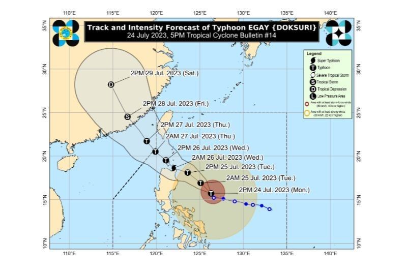
MANILA, Philippines — The state weather bureau on Monday afternoon reported that Typhoon Egay (international name: Doksuri) steadily intensified as it moves north northwestward at 10 kilometers per hour.
As of 4 p.m., the center of the eye of Egay was spotted 500 kilometers east of Baler, Aurora.
The Philippine Atmospheric, Geophysical and Astronomical Services Administration said it packs maximum sustained winds of 155 kilometers per hour near the center, gustiness of up to 190 kph, and central pressure of 955 hPa.
It added that Egay is forecast to continue intensifying and may reach the super typhoon category by late Tuesday or early Wednesday.
“Should the track forecast shift closer to the landmass of Luzon, the typhoon may peak at an intensity just below STY threshold,” PAGASA said.
“Nevertheless, EGAY is forecast to become a very strong typhoon. A weakening trend may begin by Wednesday afternoon or evening as it enters the cooler waters southwest and west of Taiwan (i.e., Taiwan Strait),” it added.
In its 5 p.m. weather bullet, the state weather said the following areas are under Tropical Cyclone Wind Signal No. 2:
Luzon
- Catanduanes
- eastern portion of Albay (Rapu-Rapu, Bacacay, City of Tabaco, Malilipot, Malinao, Tiwi), Northern portion of Camarines Norte (Calaguas and Maculabo Islands)
- eastern portion of Camarines Sur (Caramoan, Presentacion, Garchitorena, Lagonoy, San Jose, Sagñay)
- Isabela
- northern and central portions of Aurora (Dilasag, Casiguran, Dinalungan, Dipaculao)
- Quirino
- Cagayan including Babuyan Islands
- Apayao
- Kalinga
- central and eastern portions of Mountain Province (Paracelis, Natonin, Barlig, Sadanga, Bontoc)
- eastern portion of Nueva Vizcaya (Kasibu, Quezon, Diadi, Bagabag)
- eastern portion of Ifugao (Alfonso Lista, Aguinaldo, Mayoyao, Lagawe, Banaue, Hingyon, Lamut)
- central and eastern portions of Abra (Tineg, Lacub, Malibcong, Lagangilang, San Juan, Dolores, Lagayan, Danglas, La Paz, Daguioman, Boliney, Bucloc, Licuan-Baay, Sallapadan, Tayum, Bucay, Bangued, Peñarrubia, Manabo, Tubo)
- Ilocos Norte
- Batanes
Visayas
- northeastern portion of Northern Samar (Laoang, Palapag)
Residents in these areas are warned of expected gale-force winds with potential impacts of wind of minor to moderate threat to life and property.
TCWS No. 1 was also raised in the following areas:
Luzon
- Sorsogon,
- Masbate including Ticao Island, Burias Island,
- rest of Albay
- rest of Camarines Sur
- rest of Camarines Norte
- rest of Abra
- rest of Mountain Province
- rest of Ifugao
- rest of Nueva Vizcaya
- Quezon including Pollilo Islands,
- rest of Aurora
- Benguet
- Ilocos Sur
- La Union
- Pangasinan
- Nueva Ecija
- Tarlac
- Zambales
- Bataan
- Bulacan
- Pampanga
- Metro Manila,
- Rizal
- Cavite
- Laguna
- Marinduque
- central and eastern portions of Romblon (Banton, Corcuera, Romblon, Magdiwang, Cajidiocan, San Fernando)
- northern and central portions of Batangas (Calaca, Cuenca, Taysan, Lian, Tuy, Balayan, Talisay, Padre Garcia, Agoncillo, Santo Tomas, San Jose, Lemery, Lipa City, Ibaan, City of Tanauan, Mataasnakahoy, Alitagtag, Balete, Nasugbu, San Juan, San Nicolas, Rosario, Laurel, Santa Teresita, Taal, Malvar)
Visayas
- eastern Samar
- rest of northern Samar
- Samar
- Biliran
- northern and central portions of Leyte (Tunga, Pastrana, San Miguel, Mahaplag, Matag-Ob, Tolosa, Palo, Calubian, Leyte, Mayorga, Julita, Carigara, Babatngon, Dagami, Jaro, Abuyog, San Isidro, Santa Fe, Albuera, Villaba, La Paz, Palompon, Macarthur, Tabontabon, Tanauan, Merida, Ormoc City, Isabel, Javier, Dulag, Capoocan, Alangalang, City of Baybay, Burauen, Tabango, Tacloban City, Kananga, Barugo)
- northern portion of Cebu (Daanbantayan, Medellin) including Bantayan Islands, Camotes Islands
Residents in areas under Signal No. 1 may experience strong winds and the potential impact of the winds of minimal to minor threat to life and property.
PAGASA said Egay is forecast to enhance the southwest monsoon, which can bring occasional rains over areas in the western side of central Luzon, southern Luzon and Visayas.
The typhoon and the southwest monsoon can possibly bring gusty conditions to areas that are currently not under any wind signal.
The state weather bureau also advised that sea travel is risky for small vessels due to a gale warning in effect in coastal waters along the seaboards of northern and southern Luzon, the eastern seaboard of Central Luzon, seaboards of Visayas and northeastern Mindanao.
Egay is expected to move closer to areas in northern Luzon, and make a potential landfall in Luzon due to the high pressure north of the typhoon. — intern, Jose Angelo Ycasiano
- Latest
- Trending


