Chedeng outside PAR today

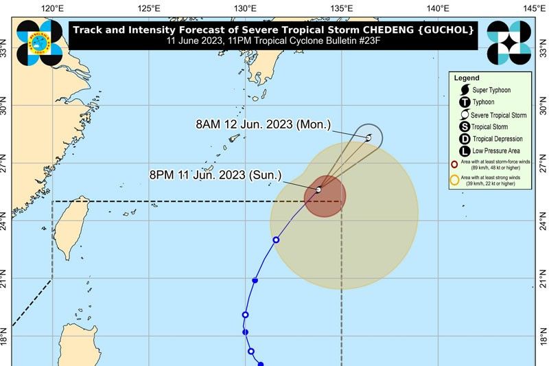
MANILA, Philippines — Typhoon Chedeng has weakened into a severe tropical storm and was expected to leave the Philippine area of responsibility last night, even as it continues to enhance the southwest monsoon or habagat.
Chedeng (international name Guchol) continues to move north-northeastward over the Philippine Sea, according to the Philippine Atmospheric, Geophysical and Astronomical Services Administration (PAGASA).
The state bureau said as of 4 p.m. yesterday, the center of Chedeng was located at 1,210 kilometers east northeast of extreme Northern Luzon with maximum sustained winds of 110 km/hour near the center, gustiness of up to 135 km/h as it moved north northeastward at 25 km/h.
PAGASA weather specialist Grace Castañeda said that while Chedeng will not have direct effect on any areas in the country, it will enhance the southwest monsoon that is causing heavy rains in the western sections of Luzon and Visayas.
“Based on our forecast track analysis, Chedeng will continue to weaken as it is expected to be downgraded to Severe Tropical Storm,” Castañeda added.
Castañeda added that among those areas affected by the enhanced southwest monsoon are Metro Manila, Zambales, Bataan, Pangasinan, Bulacan, Occidental Mindoro, and northern portion of Palawan, including Calamian and Cuyo Islands and Antique.
“Tomorrow (Monday), heavy rains will persist in Zambales, Bataan, Ilocos region, Abra, Benguet, Occidental Mindoro and northern portion of Palawan. By Tuesday, heavy rains will be experienced in Ilocos region, Apayao, Abra, Zambales, Bataan and Occidental Mindoro,” Castañeda said.
She said that strong winds prevailed in Metro Manila, Batanes, Babuyan Islands, Ilocos region, Cordillera Administrative Region (CAR), Nueva Vizcaya, Central Luzon, Calabarzon, Mimaropa, Bicol region and Western Visayas on Sunday.
“Strong winds will continue to be experienced (on Monday) in Batanes, Babuyan Islands, Ilocos region, CAR, Nueva Vizcaya, Central Luzon, Metro Manila, Calabarzon, Occidental Mindoro, Oriental Mindoro, Romblon, Marinduque, northern mainland Palawan, including Calamian Islands and Cuyo Islands, Bicol region and Western Visayas,” Castañeda said.
In a separate radio interview, PAGASA weather specialist Rhea Torres said that the heavy rains in Metro Manila and western section of Central Luzon will last until Tuesday.
“Aside from the onset of the rainy season, Severe Tropical Storm Chedeng continues to enhance the southwest monsoon causing heavy rains in many areas in the country, particularly the western section,” Torres said.
PAGASA said Chedeng will continue to move away from Philippine landmass.
- Latest
- Trending


