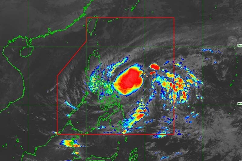
Signal No. 1 hoisted in Catanduanes, parts of Samar due to 'Amang'

MANILA, Philippines — State weather bureau PAGASA on Tuesday morning raised Tropical Cyclone Wind Signal No. 1 in Catanduanes and parts of Samar island due to Tropical Depression Amang, the country’s first cyclone of the year.
Amang was last seen 475 kilometers east of Virac in Catanduanes with peak winds of 45 km per hour near the center and gusts of up to 55 kph. It was moving west northwest at 20 kph.
Wind Signal No. 1 was hoisted in the following areas:
- Catanduanes
- Northern portion of Eastern Samar (Taft, Can-Avid, Sulat, Dolores, Oras, Arteche, San Policarpo, Jipapad, Maslog, San Julian)
- Eastern portion of Northern Samar (Catubig, Lapinig, Gamay, Mapanas, Palapag, Laoang, San Roque, Pambujan, Mondragon)
PAGASA said Wind Signal No. 1 may be raised in other areas in Eastern Visayas and Bicol region.
What to expect
According to state weather forecasters, areas under Wind Signal No. 1 may experience strong winds that may pose “minimal to minor threat to life and property.”
Heavy rain will drench Northern Samar, and the northern portions of Samar and Eastern Samar today.
Residents of Camarines Norte and the western portion of Camarines Sur will experience intense rain, while those living in the southern portion of Quezon, the rest of Bicol region, Northern Samar, and the northern portions of Samar and Eastern Samar will have heavy rain until Thursday.
“Under these conditions, flooding and rain-induced landslides are possible, especially in areas that are highly or very highly susceptible to these hazards as identified in hazard maps and in localities that experienced considerable amounts of rainfall for the past several days,” PAGASA said.
PAGASA also issued a marine gale warning over the eastern seaboards of Catanduanes and Eastern Samar, and the northern and eastern seaboards of Northern Samar due to the tropical depression.
Amang is forecast to head toward Bicol region before turning northwest for the remainder of the forecast period.
“While the current track forecast shows that the tropical depression will remain offshore over the waters east of Luzon for the next three days, the forecast confidence cone shows that a landfall scenario over the Bicol Peninsula area or the northern portion of Samar Island is not ruled out, especially for the next 36 hours,” PAGASA said.
Amang is expected to remain a tropical depression throughout the forecast period, and it may weaken into a low pressure area by late Thursday or early Friday.
Forecast position
- Apr 11, 2023 2:00 PM - 290 km northeast of Borongan City, Eastern Samar
- Apr 12, 2023 2:00 AM - 175 km east northeast of Catarman, Northern Samar
- Apr 12, 2023 2:00 PM - 135 km east northeast of Virac, Catanduanes
- Apr 13, 2023 2:00 AM - 150 km north of Virac, Catanduanes
- Apr 13, 2023 2:00 PM - 155 km northeast of Daet, Camarines Norte
- Apr 14, 2023 2:00 AM - 120 km east southeast of Casiguran, Aurora
- Latest
- Trending


