Signal No. 3 in parts of Batanes, Babuyan Islands as ‘Neneng’ intensifies

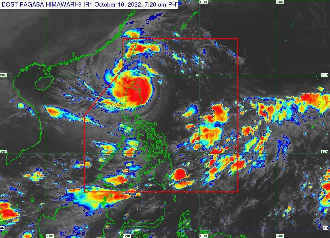
MANILA, Philippines (Updated 12:44 p.m.) — State weather service PAGASA hoisted Tropical Cyclone Wind Signal No. 3 in five areas in southern Batanes and the Babuyan Islands as severe tropical storm Neneng (international name: Nesat) continues to move west over the West Philippine Sea.
PAGASA’s 11 a.m. bulletin estimated Neneng’s center at 115 kilometers west northwest of Calayan municipality in Cagayan, moving west northward at 25 kilometers per hour, with winds at 100kph near the center and gusts up to 125 kph.
The following areas have been placed under TCWS No. 3, which can experience winds with a strength of over 89 kph in 18 hours:
- Basco, Batanes
- Mahatao, Batanes
- Uyugan, Batanes
- Ivana, Batanes
- Sabtang, Batanes
- Babuyan Islands
Areas under TCWS No. 2, forecast to experience winds moving over 62 kph and up to 88 kph in the next 24 hours:
- The rest of Batanes
- The rest of Cagayan
- Apayao
- Northern part of Abra (Tineg, Lacub, Lagayan)
- Ilocos Norte
Areas under TCWS No. 1 with winds of up to 39 to 61 kph or experience intermittent rains in the next 36 hours:
- North and central parts of Isabela (Santa Maria, San Pablo, Maconacon, Divilacan, Palanan, Ilagan City, Tumauini, Cabagan, Santo Tomas, Quezon, Delfin Albano, Mallig, Quirino, Gamu, Roxas, San Mariano, Benito Soliven, Naguilian, Burgos, Reina Mercedes, San Manuel, Aurora, Luna, Cabatuan, San Mateo, Dinapigue, City of Cauayan)
- Kalinga
- The rest of Abra
- Mountain Province
- Northern part of Ifugao (Aguinaldo, Alfonso Lista, Mayoyao, Hungduan, Banaue)
- Northern and central parts of Ilocos Sur (Sinait, Cabugao, San Juan, Magsingal, Santo Domingo, San Ildefonso, San Vicente, Santa Catalina, Bantay, City of Vigan, Santa, Caoayan, Narvacan, Nagbukel, Santa Maria, San Esteban, Santiago, Burgos, Banayoyo, Lidlidda, San Emilio, Quirino, Gregorio del Pilar, Galimuyod, City of Candon, Santa Lucia, Salcedo, Cervantes, Suyo, Sigay, Santa Cruz)
Heavy and sometimes torrential rains may be expected over Apayao, Ilocos Norte, and the northern parts of Cagayan, including the Babuyan Islands until Sunday noon. Moderate and at times heavy rains may pour over Abra, Kalinga, northern part of Ilocos Sur, and the rest of Cagayan.
Meanwhile, Batanes, Mountain Province, and the rest of Ilocos Sur, and the northern part of Isabela may experience light to moderate rains until noon.
Moderate to heavy rains may pour over Ilocos Norte until late afternoon today, while light to moderate rains, and at times heacy, may be experienced in Apayao, Abra, and Ilocos Sur.
Neneng will “most likely” intensify into a typhoon by tomorrow as it moves over the West Philippine Sea, but the state weather bureau also forecasts it existing the Philippine Area of Responsibility by Sunday evening.
Neneng will intensify into a typhoon “likely this late afternoon or tonight” as it moves over the West Philippine Sea, but the state weather bureau also forecasts it existing the Philippine Area of Responsibility by Sunday afternoon or evening.
Forecast position
- Oct 16, Sunday at 8 p.m. - 305 km West of Calayan, Cagayan (outside PAR)
- Oct 17, Monday at 8 a.m.- 460 km West of Calayan, Cagayan (outside PAR)
- Oct 17, Monday at 8 p.m. - 605 km West of Calayan, Cagayan (outside PAR)
- Oct 18, Tuesday at 8 a.m. - 680 km West of Laoag City, Ilocos Norte (outside PAR)
- Oct 18, Tuesday at 8 p.m. - 820 km West of Northern Luzon (outside PAR)
- Oct 19, Wednesday at 8 a.m. - 985 km West of Northern Luzon (outside PAR)
- Oct 20, Thursday at 8 a.m. - 1,270 km West of Northern Luzon (outside PAR)
- Latest
- Trending


