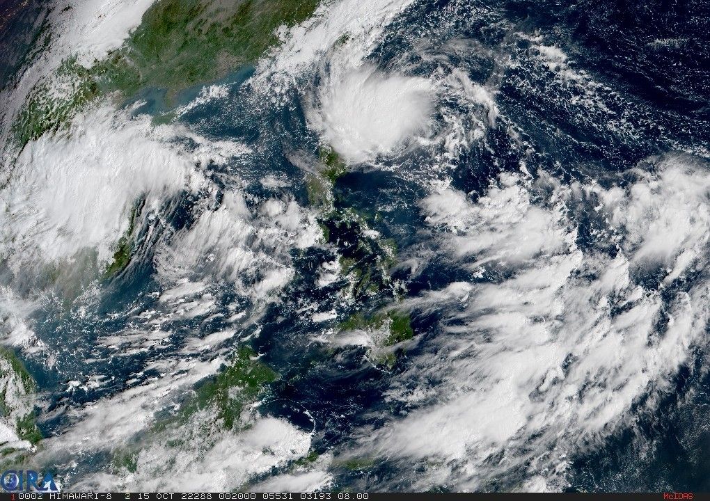
More areas under Signal No. 1 as ‘Neneng’ moves closer to Babuyan Islands, Batanes

MANILA, Philippines (Updated 11:49 p.m.) — State weather service PAGASA placed more areas under Signal No. 1 as Tropical Depression Neneng moves closer to Babuyan Islands and Batanes, where it may pass very close or make landfall Sunday morning or afternoon.
Neneng — the country’s 14th tropical cyclone this year — was last seen 510 kilometers east of Calayan Cagayan, packing winds of up to 55 kph near the center and gusts of up to 70 kph.
Signal No. 1 is hoisted in the following areas, which can expect winds between 39 to 61 kph or intermittent rains within 36 hours:
- Batanes
- Cagayan including Babuyan Islands
- Northern portion of Isabela (Santa Maria, San Pablo, Maconacon)
- Apayao
- Northern portion of Abra (Tineg)
- Ilocos Norte
PAGASA says the highest wind signal it may hoist is Signal No. 3.
Heavy to intense with at times torrential rains over Batanes and Cagayan including Babuyan Islands are expected until Saturday night, while Apayao, Kalinga, Abra, and Ilocos Norte can expect moderate to heavy with at times intense rains and the northern portion of Isabela and light to modertate with at times heavy rains may occur over the rest of Ilocos Region and Cordillera Administrative Region.
On Sunday, heavy to intense with at times torrential rains are expected over Batanes, the northern portion of mainland Cagayan, Babuyan Islands and Ilocos Norte, while Apayao, Kalinga, Abra, Ilocos Sur, and the rest of mainland Cagayan can expect moderate to heavy with at times intense rains and light to moderate with at times heavy rains may occur over the northern portion of Isabela and the rest of Ilocos Region and Cordillera Administrative Region.
The state weather service warns that under these conditions scattered flooding and rain-induced landslides are possible.
Neneng’s trough and the convergence of its circulation with the southwesterly winds may also bring occasional rains over the western portions of Mimaropa and Western Visayas, PAGASA says.
With the surge of northeasterly surface wind flow and Neneng’s approach, moderate to rough seas are expected over the eastern seaboards of Central and Southern Luzon, making sea travel risky for small vessels.
Neneng is expected to further intensify while moving over the Philippine Sea and may become a tropical storm later Saturday. It may even become a severe tropical storm while crossing the vicinity of Batanes and Babuyan Islands and a typhoon on Monday, PAGASA says.
Forecast position
- October 15, 8 p.m. - 330 km east of Calayan, Cagayan
- October 16, 8 a.m. - 140 km east of Calayan, Cagayan
- October 16, 8 p.m. - 75 km northwest of Calayan, Cagayan
- October 17, 8 a.m. - 215 km west northwest of Calayan, Cagayan
- October 17, 8 a.m. - 310 km west of Calayan, Cagayan (outside PAR)
- October 18, 8 a.m. - 315 km west of Laoag City, Ilocos Norte (outside PAR)
- October 19, 8 a.m. - 550 km west of Sinait, Ilocos Sur (outside PAR)
- October 20, 8 a.m. - 865 km west of Northern Luzon (outside PAR)
— Xave Gregorio
- Latest
- Trending


