Jolina slams Luzon; Kiko enters PAR

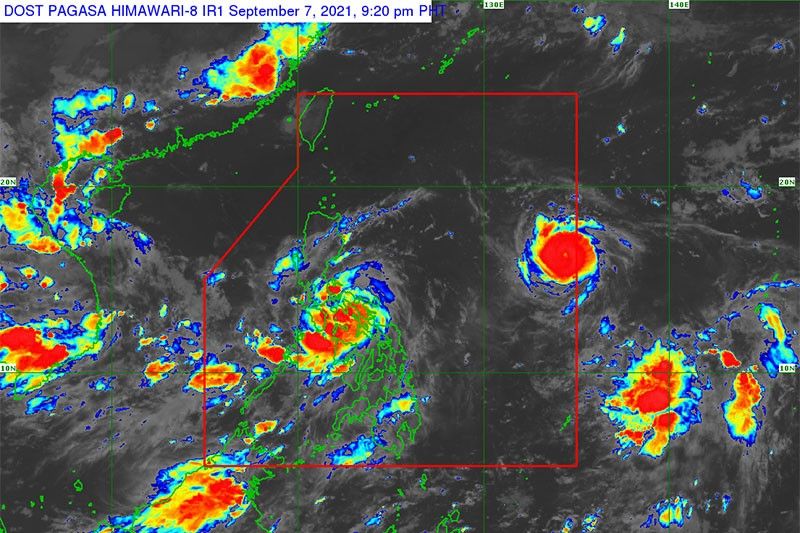
MANILA, Philippines — Severe Tropical Storm Jolina is expected to bring heavy to torrential rain over Southern Tagalog as it crosses Luzon today, according to the Philippine Atmospheric, Geophysical and Astronomical Services Administration (PAGASA).
As Jolina made its way to Luzon, tropical cyclone Kiko (international name Chantu) entered the Philippine area of responsibility yesterday, packing maximum sustained winds of 85 kilometers per hour near the center and gustiness of up to 106 kph.
Kiko was forecast to move northwestward but will likely remain far from the Philippine landmass.
It is expected to intensify into a severe tropical storm category today and reach typhoon category by tomorrow due to favorable environmental conditions.
Kiko is unlikely to bring significant amounts of rain, but Tropical Cyclone Wind Signal No. 1 is not yet ruled out over extreme Northern Luzon.
PAGASA said Jolina would bring heavy to intense and at times torrential rain Albay, Camarines Norte, Camarines Sur, Catanduanes, Marinduque, Masbate, Occidental and Oriental Mindoro, southern Quezon, Romblon and Sorsogon.
Meanwhile, moderate to heavy and at times intense rain can be expected over Aurora, Calabarzon (Cavite, Laguna, Batangas, Rizal and Quezon) and Western Visayas as well as in Metro Manila.
Widespread flooding and rain-induced landslides are possible, especially in high-hazard areas.
As of 4 p.m. yesterday, Jolina was spotted 60 kilometers west of Masbate City, packing maximum sustained winds of 100 kph near the center and gustiness of up to 125 kph.
Tropical cyclone wind signal No. 2 was raised over the western portion of Albay, southern portion of Batangas, western portion of Camarines Norte, western and southern portions of Camarines Sur, Laguna, Marinduque, Masbate including Ticao and Burias Islands, Oriental Mindoro, central and southern portions of Quezon, Rizal, Romblon and Sorsogon.
Gale-force to storm-force winds are likely to occur in areas under wind signal No. 2, which may damage structures and vegetation.
PAGASA said that Jolina would move generally northwestward traversing the Sibuyan Sea toward the southern Quezon-Marinduque area.
Jolina is expected to traverse over Tayabas Bay and make another landfall over the southwest portion this afternoon.
It will also pass through Calabarzon and Central Luzon today until tomorrow before exiting the landmass.
Jolina is expected to weaken into a tropical storm category due to frictional effects. It will emerge over the West Philippine Sea before noon tomorrow and is forecast to strengthen as it moves over West Philippine Sea.
Be vigilant
The National Disaster Risk Reduction and Management Council (NDRRMC) urged the public to remain vigilant and take precautionary measures during the typhoon.
NDRRMC regional units were reminded to continue monitoring weather updates and implement preparedness measures based on the prescribed protocols.
Residents in typhoon-affected areas were reminded to brace for destructive winds, floods and landslides due to continuous rain.
“The public is advised to monitor weather updates, take precautionary measures, heed evacuation notices issued by their local officials, follow warnings and advisories and observe minimum health protocols against COVID,” the NDRRMC said.
The Philippine National Police ordered its officers and men in Bicol and Eastern Visayas to remain alert and assist local government units affected by the typhoon.
Meanwhile, the Department of Social Welfare and Development (DSWD) is ready to provide relief assistance in areas affected by Jolina.
“Our help from the DSWD is already prepositioned, our centers are ready in case we need to evacuate,” presidential spokesman Harry Roque said as he appealed to the public to follow health protocols in evacuation centers to prevent the spread of COVID.
18 missing
Eighteen fishermen were reported missing in Samar provinces while almost 2,000 passengers were stranded in Bicol when Jolina made landfall yesterday morning, according to the Philippine Coast Guard (PCG).
PCG spokesman Commodore Armand Balilo said the agency’s Eastern Visayas station reported that 12 of the fishermen went missing in the waters off Sierra town in Western Samar; four in Motiong and two in Catbalogan, both in Samar.
As of yesterday afternoon, Balilo said the PCG had yet to confirm the number of missing fishermen.
Balilo said there were 1,946 passengers stranded in some ports of Eastern Visayas and the Bicol region after sea operations were suspended.
He said 1,441 passengers were stranded in six ports in Eastern Visayas due to “rough to very rough” sea condition and 505 others in Bicol’s 12 ports due to “moderate to rough” sea condition.
Balilo said 17 vessels and 682 rolling cargoes were stranded in Eastern Visayas and Bicol.
Aside from the missing fishermen and stranded passengers, no other untoward maritime incidents were reported due to Jolina.
The travel suspension remained in effect as of yesterday afternoon and would be lifted once the weather improves. – Robertzon Ramirez, Helen Flores, Michael Punongbayan, Emmanuel Tupas
Related video:
- Latest
- Trending


