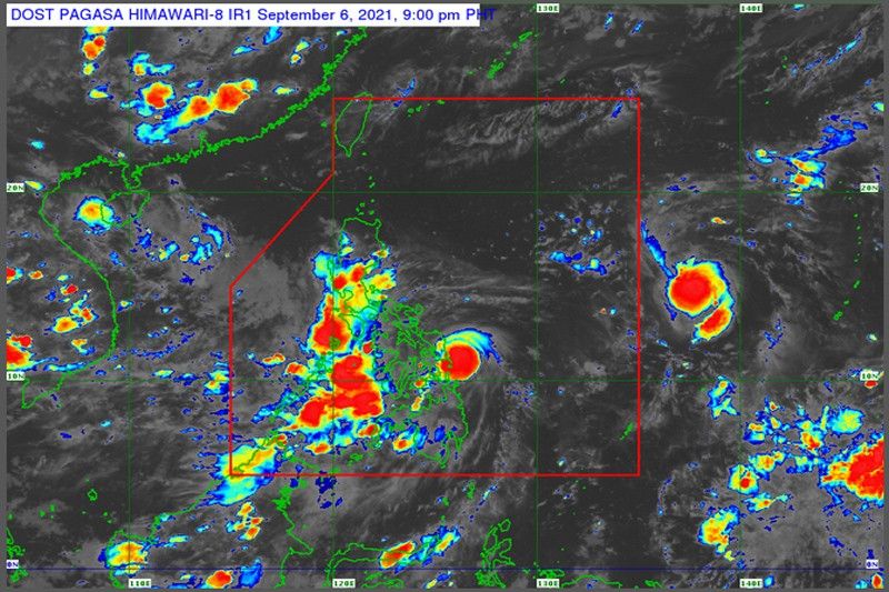
Storm Jolina bringing moderate to heavy rains

MANILA, Philippines — A low-pressure area which entered Philippine territory over the weekend has intensified into a tropical storm and is expected to bring moderate to heavy rains in the next four days, the state weather bureau said yesterday.
At a press briefing, Philippine Atmospheric, Geophysical and Astronomical Services Administration (PAGASA) senior weather specialist Chris Perez said the weather system spotted in Guiuan, Eastern Samar last Sunday developed into a tropical depression around 4 a.m. and was given the local name Jolina.
In its 5 p.m. cyclone bulletin, however, PAGASA said Jolina has further intensified into a tropical storm.
As of 4 p.m., the center of Jolina was spotted at 95 kilometers east of Guiuan. It was packing maximum sustained winds of 75 kms per hour near the center and gustiness of up to 90 kph. It was seen moving west northwest over the West Philippine Sea at 20 kph.
Perez said there is high chance for Jolina to further intensify before reaching land mass. It is expected to make first landfall on Thursday morning, possibly in Isabela or Cagayan.
Jolina was forecast to leave the Philippine area of responsibility by Friday but not before dumping moderate to heavy rains in its track.
“Considering these developments, the public and disaster risk reduction and management offices concerned are advised to take all necessary measures to protect life and property. Persons living in areas identified to be highly or very highly susceptible to these hazards are advised to follow evacuation and other instructions from local officials,” PAGASA said in its cyclone bulletin.
Jolina is the 10th storm to hit the country this year.
As of 5 p.m. yesterday, Tropical Cyclone Warning Signal (TCWS) No. 2 was raised over Eastern Samar, eastern portion of Northern Samar specifically over the municipalities of Palapag, Mapanas, Gamay, Lapinig, Laoang, Catubig, Las Navas and Pambujan and the northeastern portion of Samar specifically over Matuguinao.
TCWS No. 1, meanwhile, was raised over the eastern portion of Camarines Sur and over Catanduanes, Albay and Sorsogon in Luzon; Biliran, eastern portion of Leyte, eastern portion of Southern Leyte, the rest of Samar and rest of Northern Samar in Visayas; and over Dinagat Island, Siargao and Bucas Grande Islands in Mindanao.
PAGASA said areas under cyclone warning signals must prepare for heavy to intense rainfall and strong winds in the next 24 hours.
Meanwhile, light to moderate with at times heavy rains can be expected over the Bicol region and the rest of the Visayas.
“Under these conditions, isolated to scattered flash flooding and rain-induced landslides are possible, especially in areas that are highly or very highly susceptible to these hazards as identified in hazard maps,” PAGASA warned.
The weather bureau said the highest warning signal that will be raised throughout Jolina’s passage will be TCWS No. 2.
PAGASA said Jolina is also expected to cause moderate to rough sea conditions with waves as high as 1.2 to 2.8 meters, especially in the eastern seaboards of the Visayas and Mindanao.
“Mariners of small seacraft are advised to take precautionary measures when venturing out to sea. Inexperienced mariners should avoid navigating in these conditions,” PAGASA said.
Metro Manila and the rest of Luzon can expect cloudy to partly cloudy skies with isolated rainshowers due to localized thunderstorms.
Meanwhile, Perez said the other low-pressure area spotted in Basco, Batanes last Sunday has already left the Philippine area of responsibility.
Perez, however, said the bureau is monitoring another tropical depression still outside the Philippine area of responsibility.
As of 3 p.m. yesterday, the depression was spotted at 1,530 km east of Southern Luzon, with maximum sustained winds of 55 kph near the center and gustiness of up to 70 kph. PAGASA said it was slowly moving north-northwest.
Perez said the tropical depression will most likely enter the country’s territory by Wednesday.
He said there was currently no direct interaction between Jolina and the tropical depression and there was slim chance for them to overlap.
He, however, advised concerned disaster response agencies as well as local government units, especially in the Visayas region, to continue monitoring cyclone bulletins.
Related video:
- Latest
- Trending


