'Emong' accelerates, seen to exit PAR by Tuesday morning
MANILA, Philippines — Tropical Depression "Emong" has accelerated as it continued to move toward Batanes-Babuyan Islands area, PAGASA said on Monday.
Weather forecasters said Emong was last seen at 215 kilometers east northeast of Calayan in Cagayan, or 160 km east southeast of Basco in Batanes.
It remains with 55 kilometers per hour peak winds, and gusts of up to 70 kph. Emong, the fourth storm to enter the country this year, threads a northwestward direction at a speed of 45 kph.
As of 5 p.m., these areas are still under Signal No. 1:
- Batanes
- northeastern portion of Cagayan (Santa Ana, Gonzaga)
- Babuyan Islands
PAGASA said Batanes and Babuyan Islands will experience moderate to heavy with at times intense rains from today until Tuesday morning.
"Under these conditions and considering antecedent rainfall, isolated to scattered flash flooding and rain-induced landslides are highly likely," it added in a bulletin, "especially in areas with high or very high susceptibility to these hazards as identified in hazard maps."
Emong will keep moving generally northwestward as it makes its way to Extreme Northern Luzon-Taiwan area.
But per its forecast track, it could pass close or make landfall in the vicinity of Batanes-Babuyan Islands sometime between 6 p.m. or 10 p.m., Monday.
The weather bureau said Emong will likely leave the country's jurisdiction by early Tuesday morning, but may also intensify into a tropical storm in the next 12 hours.
On coastal waters, PAGASA warned that seaboards of areas under Signal No. 1 and the remaining seaboard of Cagayan would see rough to very rough seas.
It added that sea travel would be risky over the said waters, especially for small seacrafts.
Forecast Position
- Tuesday morning: 170 km west northwest of Itbayat, Batanes
- Tuesday afternoon: 470 km northwest of Itbayat, Batanes (Outside PAR)
- Wednesday morning: 795 km northwest of Itbayat, Batanes or in the vicinity of Ganzhou, Jiangxi, China (Outside PAR)
— Christian Deiparine


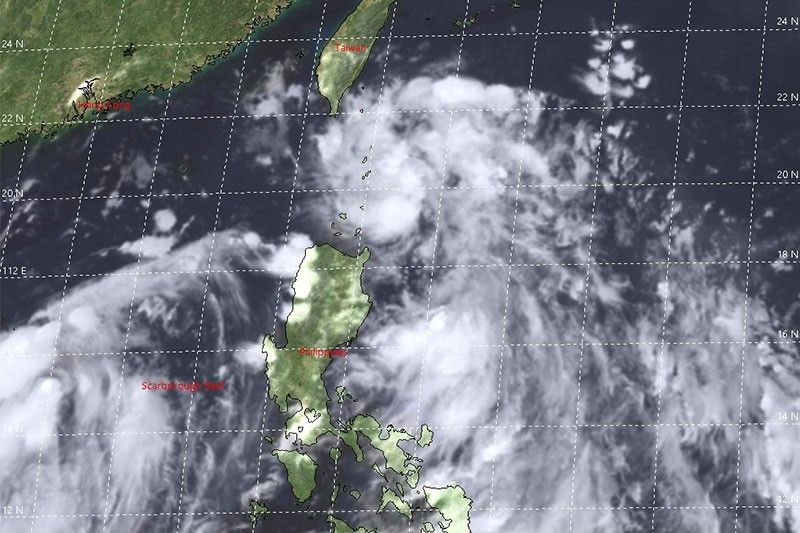
Follow this page for updates on Emong, the fifth tropical cyclone to enter the Philippines on 2021. — Main photo from JMA
Tropical Depression Emong has passed very close to Batan and Sabtang Islands, state weather bureau PAGASA says Monday night.
The weather disturbance will bring moderate to heavy with at times intense rains over Batanes and Babuyan Islands from Monday night through Tuesday morning.
At 7 p.m., Emong was located 90 km west of Basco, Batanes with winds of 55 kph and gusts of 70 kph. It is moving northwestward at 50 kph.
Batanes, and portions of Cagayan (Santa Ana and Gonzaga) including Babuyan Islands remain under Tropical Cyclone Wind Signal no. 1 as Tropical Depression Emong accelerates.
The tropical cyclone continues to approach the Batanes-Babuyan Islands area and is forecast to bring moderate to heavy with at times intense rains over the area.
At 4 p.m., Emong was located 215 km east northeast of Calayan, Cagayan or 160 km east southeast of Basco, Batanes with winds of 55 kph and gustiness of 702 kph. It is moving northwestward at 45 kph.
Tropical Depression Emong slightly intensifies as it moves north-northwestward over the Philippine Sea.
Signal No. 1 is still up over Batanes and the northeastern portion of Cagayan (Santa Ana, Gonzaga) including Babuyan Islands. This means that winds of 30 to 60 kph may be expected in at least 36 hours.
At 4 p.m., Emong was located 780 km east of Virac, Catanduanes with winds of 55 kph and gusts of up to 70 kph. It is moving northwestward at 25 kph.
TROPICAL CYCLONE BULLETIN NO. 2
— PAGASA-DOST (@dost_pagasa) July 4, 2021
Tropical Depression “#EmongPH”
Issued at 5PM 04 July 2021
Valid for broadcast until the next bulletin at 11PM today.
TROPICAL DEPRESSION “EMONG” SLIGHTLY INTENSIFIES WHILE MOVING NORTH-NORTHWESTWARD OVER THE PHILIPPINE SEA EAST OF SOUTHERN LUZON. pic.twitter.com/ewaYTwguMq
Signal No. 1 is hoisted over Batanes and some localities in Cagayan including Babuyan Islands in anticipation of the arrival of strong winds caused by Tropical Depression Emong.
At 10 a.m., Emong was located 700 km east northeast of Guiuan, Eastern Samar or 790 east of Catarman, Northern Samar.
The weather disturbance has winds of 45 kph and gusts of 55 kph. It is moving northwestward at 25 kph.
As of 8 a.m., the low pressure area east of Guiuan, Eastern Samar has developed into a tropical depression, state weather bureau PAGASA says.
The weather disturbance will be called Emong, the fifth tropical cyclone to enter the country this year.


- Latest
- Trending